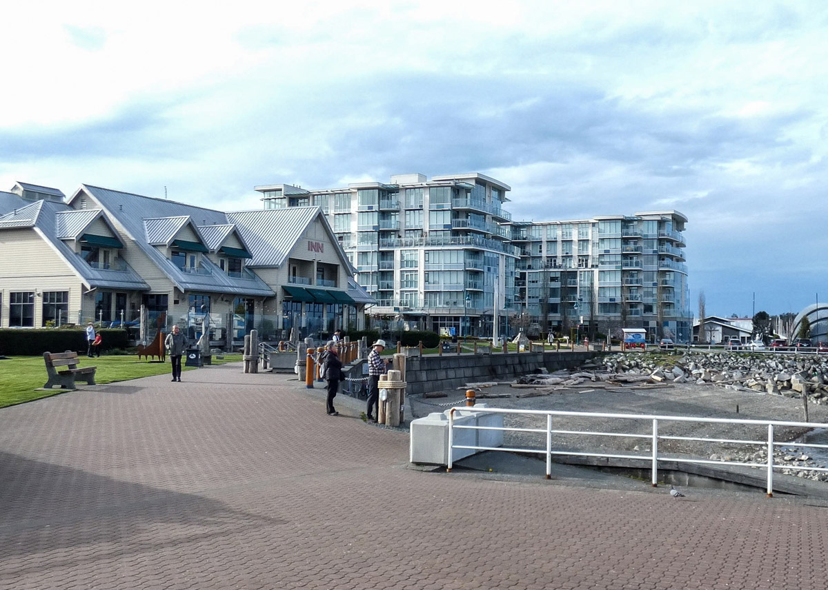
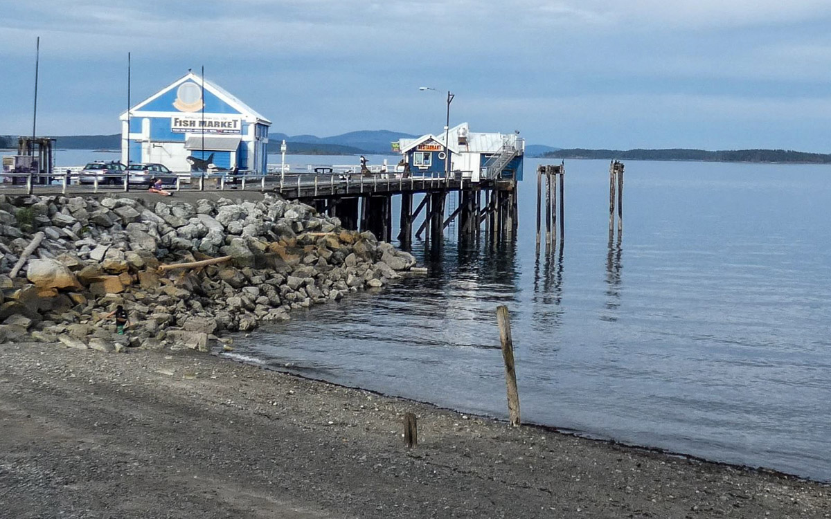
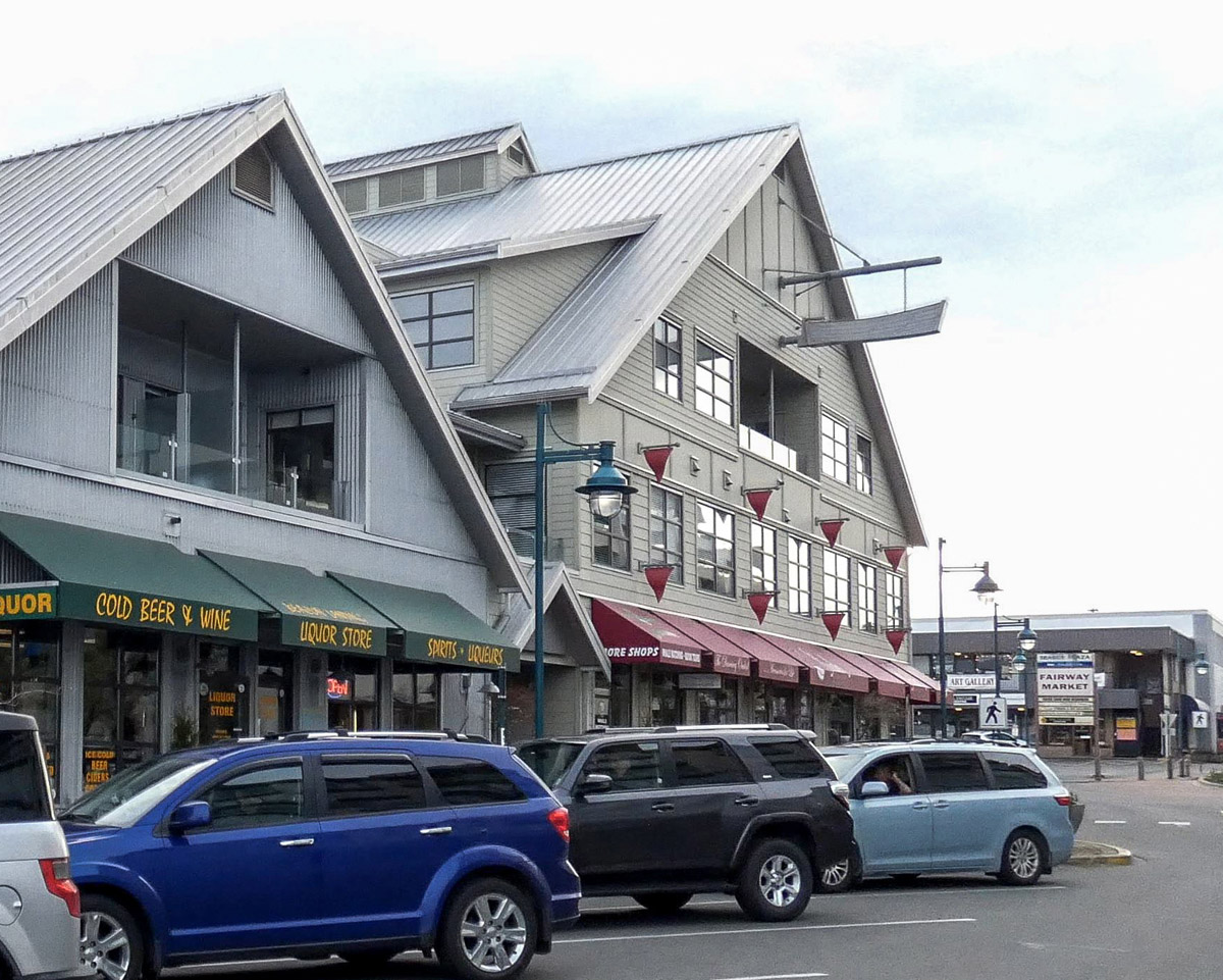
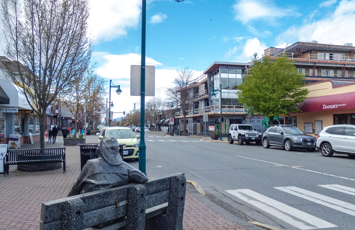
Walking Tour
Sidney By The Sea
The Story of SET,TINES
Natalie Dunsmuir
Sidney Museum & Archives P1991.46.1
The town of Sidney is built on land that has been inhabited by the W̱SÁNEĆ First Nations since time immemorial. They called this place SET,TINES, which means "chest sticking out," in reference to the way the land juts out into the water.
The town first came into being in the late nineteenth century and slowly developed as more settlers encountered the rich beauty and abundance of this region. On this tour, we will explore the unique individuals who have shaped this place and delve into the stories, many of them little known, that make Sidney what it is today.
This tour will start on the Sidney waterfront near Glass Beach, and Stop One will explore the rich history of the W̱SÁNEĆ People. Next, the tour will follow the waterfront trail towards Beacon Avenue and the pier, with two stops exploring Sidney's early economy and the industries which were key to its growth. On the pier, Stop Four will delve into the tragic history of the S.S. Iroquois ferry. Next, the tour will follow Beacon Avenue west. Stop Five will explore the founding of the town and its early settlers, and Stop Six will take visitors on a slight detour down First Street to the location of the old railway station. Here, we will learn about the various transportation routes which were key to Sidney's settlement and growth.
From there, the tour will return to Beacon Avenue. Stops Seven and Eight will dive into the history of important businesses that have existed along Beacon Avenue over the years and explore how they shaped the community. Stops Nine and Ten will tell the story of the rise and fall of Sidney's Chinatown as the tour moves farther along Beacon Avenue. Stop Eleven will take visitors down Fifth Street to the north to see one of Sidney's oldest buildings, and the tour will end at Stop Twelve, back on Beacon Avenue. Here, we will learn about Sidney's contributions to the Second World War and how this conflict in turn shaped the town.


This project is a partnership with the Sidney Business Improvement Area Society and the Sidney Museum & Archives.


1. The W̱SÁNEĆ People
Sidney Museum & Archives P1985.2.3
ca. 1890s
This early image of Sidney's waterfront dates to 1890. The white building at left is the Sidney Hotel. At the centre is Dickinson's Store, and on the right in the distance you can see the British Columbia Lumber Company.
While this image may show a time very early on in the settler history of Sidney, it doesn't portray the thousands of years of human history that came before European contact in this region. The Saanich Peninsula, as it is now called, has a rich, vibrant First Nation's history and culture, one which stretches back to time immemorial and carries on into the present.
* * *
On the Saanich Peninsula, the W̱SÁNEĆ People built their permanent winter settlements, and would travel by canoe to the many smaller islands nearby. The sea has always been central to the culture and way of life of the W̱SÁNEĆ. They created a culture that is intrinsically tied to the natural world they inhabited. David Elliot, a W̱SÁNEĆ knowledge keeper, described the worldview of his people:
"Our people lived as part of everything. We were so much a part of nature, we were just like the birds, the animals, the fish. We were like the mountains. Our people lived that way. We knew there was an intelligence, a strength, a power, far beyond ourselves. We knew that everything here didn’t just happen by accident. We believed there was a reason for it being here. There was a force, a strength, a power somewhere that was responsible for it. That is the way our people lived. They lived according to that belief, according to that knowledge. The universe lies before you…”3
Before European colonists disrupted their way of life and caused the loss of much of their language, culture, and communities, the W̱SÁNEĆ People spoke SENĆOŦEN, which is a dialect of the Northern Straits language.4
While colonisation and the opening of residential schools in the region led to the widespread disruption and decline of the W̱SÁNEĆ language, great strides have been made to retain and cultivate this important way of life. A crucial step in this process was the devising of the SENĆOŦEN alphabet, a way of putting the language into written form in order to preserve it.
This alphabet was created by Dave Elliot, who was born on the Tsartlip reserve in June of 1910 and spent much of his life striving to restore the culture and language which Europeans had attempted to take from his people. He created the SENĆOŦEN alphabet in the winter of 1978, after studying linguistics to find a way to best capture the complexity of the language. Elliot recognized the importance of the language and saw firsthand the linguistic decay caused by the area's residential schools: “I saw how our old people lived before our own speaking system was broken down. Our people were the wealthiest on earth. We needed nothing. We lived in a virtual paradise”.6
Today, language revitalization is a major priority for many members of the community. The English place names which are currently most commonly used to describe this region are relatively new. Before the area of Sidney was named "Sidney" by European settlers.5
The W̱SÁNEĆ Leadership Council "promotes respect for W̱SÁNEĆ culture, traditional practices, and language."7 Those who wish to learn more about this organisation and about the rich culture and history of the W̱SÁNEĆ people can visit their website at https://wsanec.com, which includes a detailed place name guide and a page of settler resources.
Much of the rest of this tour will focus on the European history of the region, although W̱SÁNEĆ history will be included whenever possible. There are few photos available which portray the W̱SÁNEĆ People, and written information is often scarce. However, the importance of local First Nations stories to this place we now call home cannot be overemphasised.
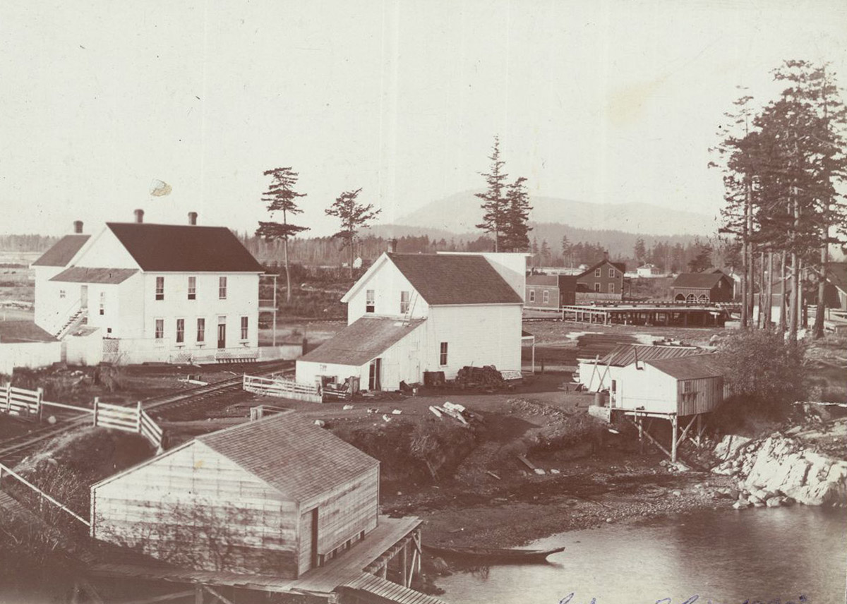
2. The Saanich Cannery
Sidney Museum & Archives P1985.15.1
1922
This photo from 1922 shows Sidney's waterfront during the community's early days. To the left of the image is the Copeland and Wright Boatyard, while to the right is the Saanich Cannery and the Sidney Mill office. The cannery opened in 1905 and for many years, served as a crucial employer within the town. It was one of many industries which supported the town in its early years after the first arrival of European settlers. The clams were supplied by local W̱SÁNEĆ People, which created ties between the First Nation and European colonisers.
* * *
The cannery began operations in 1905, and its beginnings were rather informal. White adapted the back of his merchandising store into a makeshift cannery, and much of the work was done by hand. The local origins of the clams were celebrated, with a label that included a map of North Saanich. In the first year, White's cannery produced 3,500 cases of clams. Bolstered by this success, White expanded and adapted, partnering with C.C. Cochran and merging with the Sidney Trading Company. New, more official premises were opened along the waterfront.
Like many industries of the time, the Saanich Cannery adapted to reduce waste and increase profit and efficiency. Rather than discarding the thousands of broken clam shells which were produced each day, White and his company crushed the shells and sold them. Some became chicken scratch, while other shells were used in the process of road-building. In the off-season, the cannery transitioned away from clams and produced canned fruit instead, specialising in strawberries and loganberries but also canning apples, prunes, plums, and pears.
For decades, the Saanich Cannery created valuable employment to the inhabitants of the town and surrounding area, as well as providing income to the W̱SÁNEĆ locals who harvested the clams. But in 1939, the company was sold to the B.C Packers, who then sold it to the Canadian Canners. In 1942, the cannery was closed, and by the mid-1950s, the main buildings had been demolished. A few remained, leased to Sidney Seaweed Products, until 1966. Today, the area that once held the Saanich Cannery buildings is home to the Sidney Hotel parking lot.
3. Industry's Rise and Fall
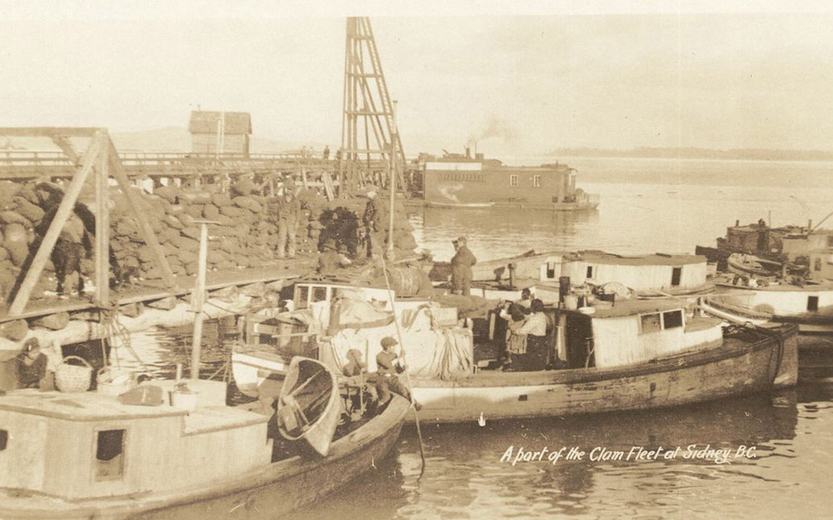
Sidney Museum & Archives P2010.3.14
In this postcard of Sidney's early waterfront, several small boats line the harbour, some filled with people ready to depart. The boats were part of Sidney's clam fleet, and many would have belonged to the local First Nations people, who were a crucial part of the clam harvest. Note the small boy on the front of the nearest vessel, who wields a long wooden pole to help with navigation within the harbour. The clam harvest, and the cannery which it supplied, were only one section of Sidney's diverse industrial landscape. Other businesses included a roofing factory, a sawmill, a brick factory, a flour mill, and even an explosives factory.
* * *
The sawmill, founded in partnership with the Brethours' cousin John White, operated in Sidney for several decades, although it experienced fluctuating periods of stagnation and prosperity. It went through several owners and several names, and was closed between 1913 and 1917, amid war and economic downturn. When G.H. Walton purchased the building and its assets in 1917, he poured roughly $20,000 into improvements to the facilities. Before long,the sawmill was producing twenty million board feet per year. Crucially, it also employed 146 people.2 The mill was eventually closed in 1934 during the Great Depression after struggling to stay afloat for five years of hardship and struggle.
Another key early industry in Sidney was the Sidney Rubber and Roofing Company, which found great success in supplying the growing communities of the Greater Victoria area with rubberised roofing felt and asphalt roofing paper. With populations expanding, new houses needed to be built, and there was a high demand for building materials across BC. The rubber company was formed and incorporated in 1912 and thrived for nearly a decade. In addition to roofing materials, the plant also sold a diverse range of products made from crude oil, including street paving materials, low-grade lubricating oil and "tree spray for fruit trees, newspaper ink, black enamel, paints for iron work and ship bottoms, insulating tape, and damp proof compounds, deck pitch, marine glue,… etc.”3 Ultimately, however, limited access to fresh water in Sidney halted expansion and instead led to the development of a new plant in Victoria. Moreover, in 1921, a fire ripped through the Sidney factory, reducing it to rubble. Rather than a costly rebuild, the company's owners decided to focus their attention on the new Victoria plant.
These key industries were joined by others,such as the Bazan Bay Brickworks plant founded in 1910 and the Canadian Explosives Ltd factory opened on nearby James Island in 1913. Today, all of these industries are now long gone. There were numerous factors behind this industrial decline, such as war and Canada’s fluctuating economy contributing to periods of financial difficulty for many businesses both in Sidney and across the country. On a local level, the mere fact that many of these companies operating in wooden buildings made fire a particular risk. Business competition came from many places, from the growing city of Victoria and mainland population centres, to the nearby United States. Today, much of Sidney's economy is centred on tourism and the service industry, with the small town branding itself as the "Booktown" of the west coast, due to the high number of bookstores that line its streets. A few of the old industries do remain, fishing and boat building among them, but most have moved on. The town has changed, but along its waterfronts, one can still glimpse images of the past.
4. The S.S. Iroquois
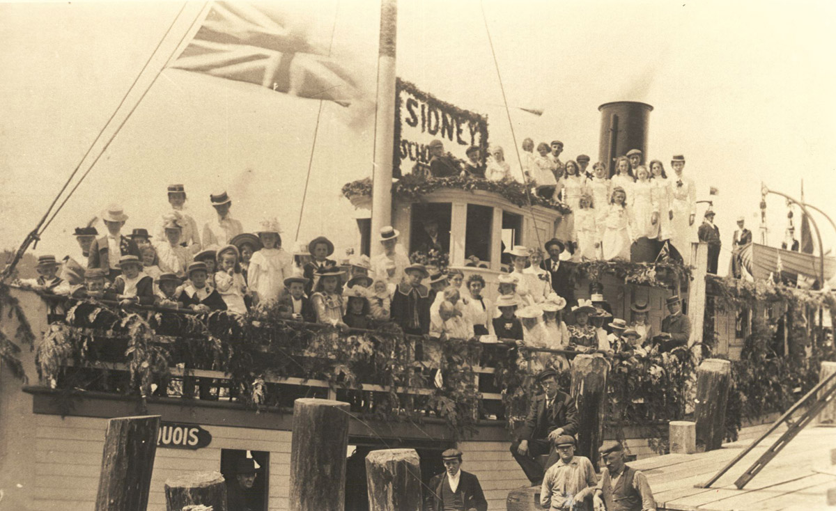
Sidney Museum & Archives P1981.25.1
1902
This photo was taken in 1902 and shows the students of Sidney School on board the S.S. Iroquois for a school picnic. The children pose for the picture in their good clothes and hats, and the boat is decked in pine boughs for the occasion. For over a decade, his boat was an important part of not only the Sidney community but the island communities it served across the water. Its story, however, does not have a happy ending.
* * *
The ferry ran for over a decade, becoming an established part of the islands' transportation network. Sadly, this came to an abrupt end on April 10th, 1911, when disaster struck. It was a stormy day, with winds gusting up to 100 kilometres per hour, but neither the captain, Albert A Sears, or his partner Arbuthnot D Munro were worried—they had travelled in worse conditions. The boat was heavily laden, carrying at least 31 passengers and crew and a host of freight goods, including 20 bales of hay, 20 cases of pick handles, a tonne of iron bars, 10 tonnes of fertiliser, and large quantities of rice and coal for ballast.3 While the captain and crew may not have been concerned by the conditions that day, some passengers evidently were, choosing to remain behind on the dock.
They were the lucky ones. Within 15 minutes of leaving the dock at Sidney, the Iroquois was buffeted by waves and suddenly began to list heavily. Some of the cargo on deck had shifted, unbalancing. Captain Sears immediately sent his crew to rebalance the goods, but it was too late. The Iroquois capsized, trapping the terrified passengers and crew as it sank. This made escape exceedingly difficult.. Captain Sears, according to his family, had to kick the ceiling out of the steering house in order to escape himself. For most passengers, getting out was nearly impossible. The captain managed to help a few passengers into one of the two lifeboats, but it had been damaged in the sinking and quickly foundered.
In the end, only ten or eleven people made it back to shore safely. Only four of these were passengers. Three of the passengers were rescued by local First Nations men Donat Charlie, Bob Klutwhalem, and William Tzouhalem.4 The three men saw the vessel in distress and paddled to the rescue in their dugout canoe, risking their lives to try to bring the floundering passengers to shore. They were later awarded the Government of Canada Medal For Gallant and Humane Services Rendered in Life Saving From Shipwrecked Vessels. The other rescued passenger was Margaret Barton, the only woman to survive. She made it to shore after deckhand Joseph Smith gave her his lifebelt.
In the aftermath of the disaster, Sidney residents and the nearby police launched a rescue effort to search for survivors and to recover the bodies of victims. Some bodies, however, were never recovered. The tragedy shook the small communities along the peninsula, and many searched for answers. An investigation was launched, and ultimately, Captain Sears was charged with both negligence and failure to perform his duty. It was found that he had failed to properly secure the cargo and had abandoned his passengers in order to save himself. As a result, he had his Master's Certificate revoked and was disgraced forever after.
5. Founding a Town
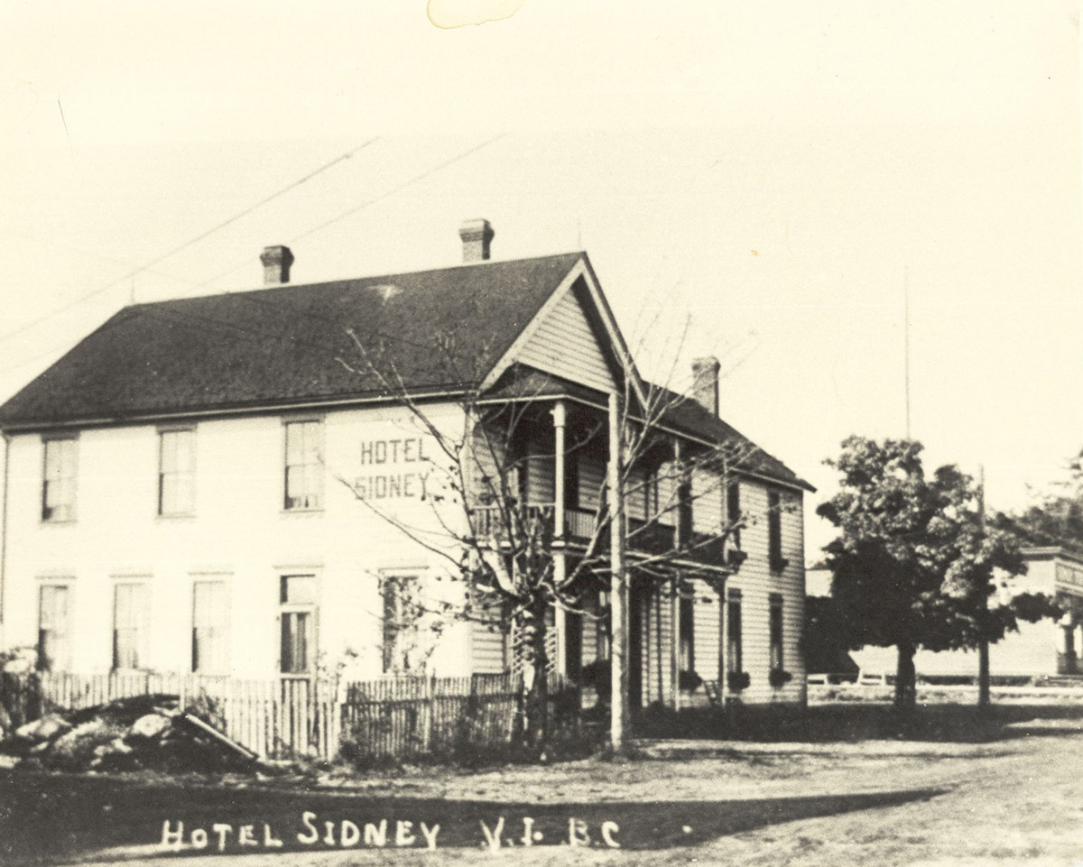
Sidney Museum & Archives P1976.283.1
1895
This picture, taken in 1895, shows the Hotel Sidney, which once stood in this location. The hotel was one of the earliest landmarks of the fledgling town and was built on this corner in 1891. It was first known as the Sidney House, but would eventually change its name to the Hotel Sidney. The hotel was founded in the same year as the town of Sidney, and it watched as the community slowly grew around it.The hotel remained an important part of the town for over fifty years, but in 1948, fire claimed the structure.
* * *
Among the families that moved to the area during this period were the Brethour brothers. In 1891, they subdivided fifty acres of their land to create the Township of Sidney. Within two years, the community had developed to include the Sidney Hotel, a general store, a boat building shop, and a post office. The first school was constructed in 1894, and a second school was opened in North Saanich in the early 1900s. Sidney was incorporated as a village in 1952 and as a town in 1967.
Of course, the name "Sidney" is not the original name of the area. The spot where the town sits was originally called SET,TINES in the local language of SENĆOŦEN. It translates to "chest sticking out", describing the geography of the local coastline.3
Most of the ancient Indigenous names for places—toponyms—were intimately tied to the land itself, often referencing local geography or mythical and historical events that occurred there. The process of European colonisation usually meant the erasure of these names, and their replacement with new names that had little connection to the physical places they described.
William Banfield was an employee of the Hudson's Bay Company and one of the first European settlers on western Vancouver Island. He wrote about how distasteful he found this practice:
"However much the old navigators' names are entitled to respect, good taste would lead us at the present day to adopt the Indian names [which] in most instances are much prettier, many of them having a natural beauty of sound... Great Britain's colonies have enough Royal names, noble names, and titles of our grandfathers and grandmothers and birthplace names."4
Ironically his name was later affixed to a place on that part of the Island, and later cartographers spelled it wrong, giving us the name for Bamfield.
The name "Sidney" came about in a similarly arbitrary manner. It was itself derived from nearby Sidney Island. As for that island's name, its first European name was "Sallas Island". This was later changed to Sidney, after Frederick William Sidney, a Royal Navy officer in the Hydrographic Service of the Royal Navy, which was responsible for ocean mapping and surveying.5 A huge share of the settler place across this entire region come from British naval officers—especially those officers responsible for putting names for things on maps.
When this community was first taking shape, it needed a name. Julius Brethour was asked for one, and he reportedly looked across the water, saw Sidney Island, and said "It will be called Sidney".6 And that was that.
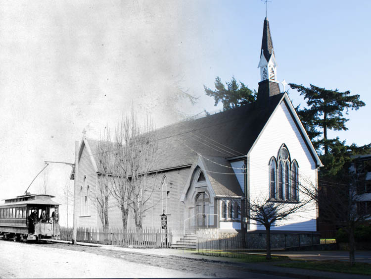
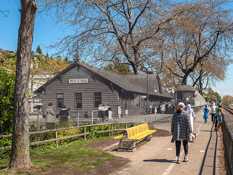
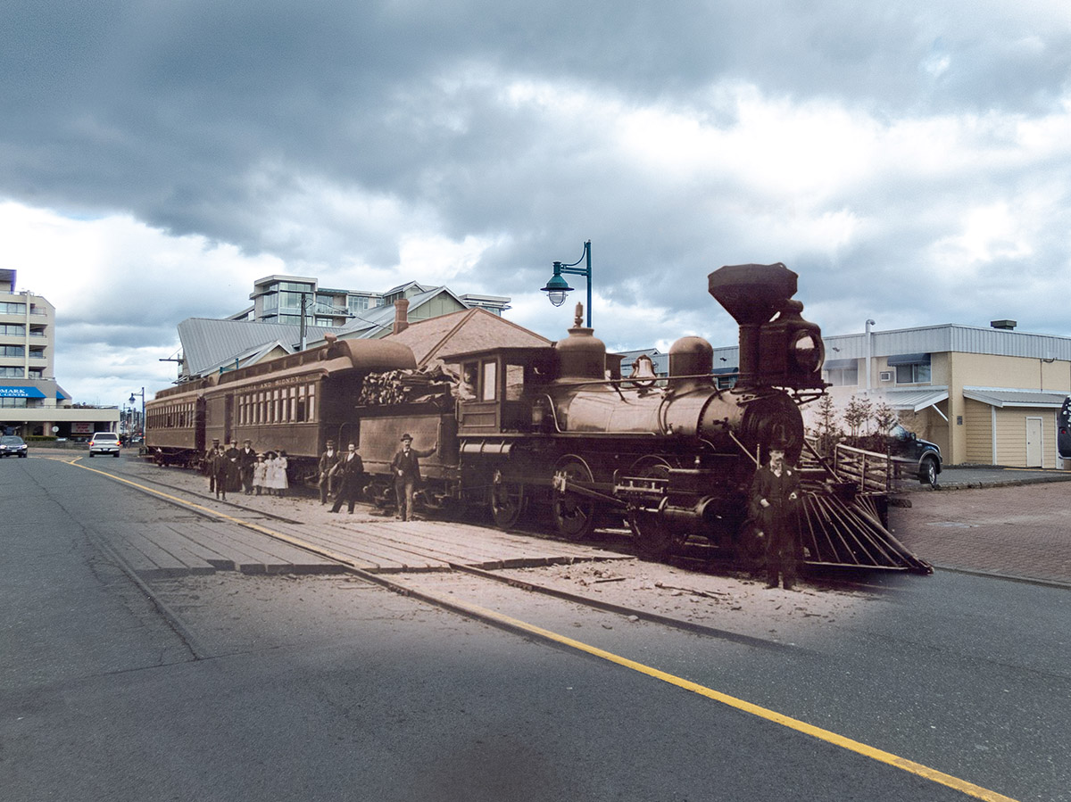
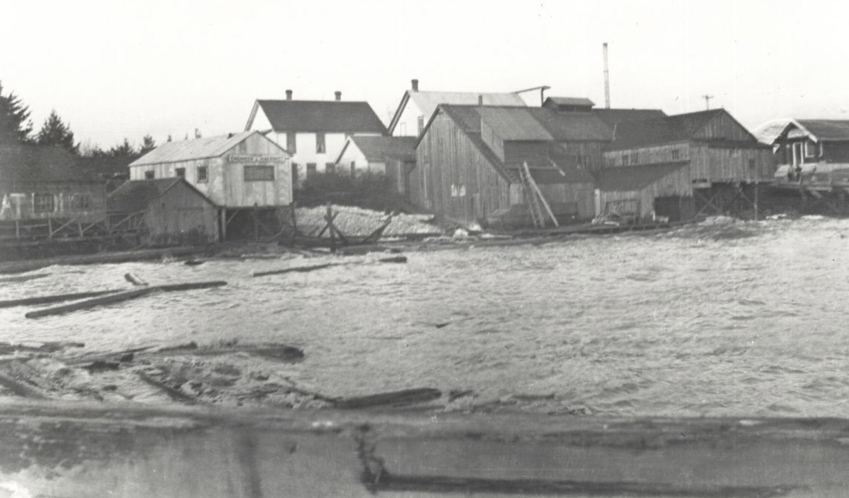
6. The Victoria & Sidney Railway
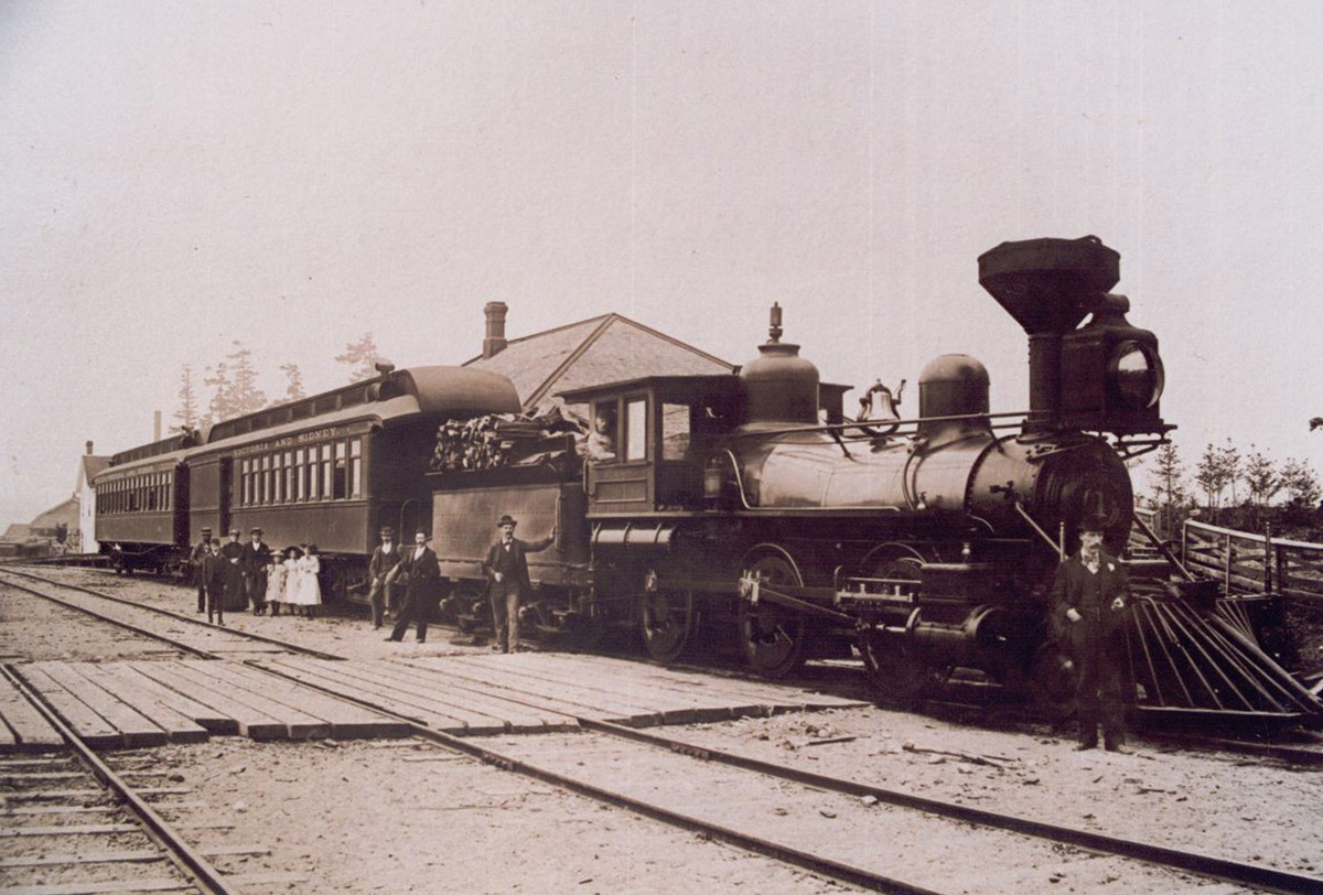
Sidney Museum & Archives P1991.46.1
This photo shows a train preparing for departure from the station in Sidney. The station can be seen to the left, in the background of the picture, and the train is loaded with cordwood. Several men and women stand on the tracks beside it. This locomotive was part of the Victoria & Sidney Railway, fondly known at the time as the "Cordwood Express" due to the fact that it was both fuelled by cordwood and also used to deliver cordwood across the island. It carried both passengers and freight, and you can see two passenger cars in this picture. The railway was important to Sidney's early growth and provided a reliable transportation corridor across the island.
* * *
In the early days of colonisation, travel across Vancouver Island by land was limited to rustic dirt roads, often traversed by oxen and horse-drawn carts. Agricultural products, a key part of the local economy, were transported in this way.This system, however, was neither efficient nor fast, and in the early 1890s, work began on a railway system that would connect Sidney to Victoria. Railway construction was a booming business across Canada at the time, yet the first attempt at an island link, proposed by B.C. Premier Amor de Cosmos in 1891, was voted down by Victoria's city council 6 to 3.1 A year later, however, when the Victoria and Sidney Railway Company brought forward a proposal for a railway link between the communities, it was approved.
The Victoria and Sidney Railway ran between a station near Victoria's city hall and a station located in Sidney at the intersection of Beacon Avenue and First Street. Between these two stops there was only one other station, at Royal Oak, where Louis Duval opened the Royal Oak Hotel. Construction took nearly two years and involved the labour of approximately 200 workers.2 The first passenger journey took place on May 11th, 1894, beginning several decades of rail transportation on the island. Along with goods and passengers, the route also transported the mail.
In the following years, two more railroads were constructed in the Sidney area. The British Columbia Electric Railway opened a route between Sidney and Deep Cove in 1913, and in 1917, the Canadian Northern Pacific Railway opened a line from Sidney to Patricia Bay. Yet none of these railways lasted long. The cordwood supply (and market) declined, populations levelled out, and roads became increasingly reliable. Government subsidies for the Victoria and Sidney Railway ran out in 1919, and the line shut down operations soon after. Much of the land used in the route was paved to become roads, and one section of road in Saanichton was named "Veyaness Road"—a slightly garbled tribute to the "V & S Railway" that came before it.3
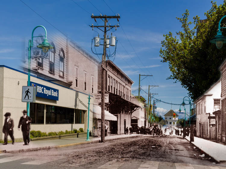
7. A Place to Gather
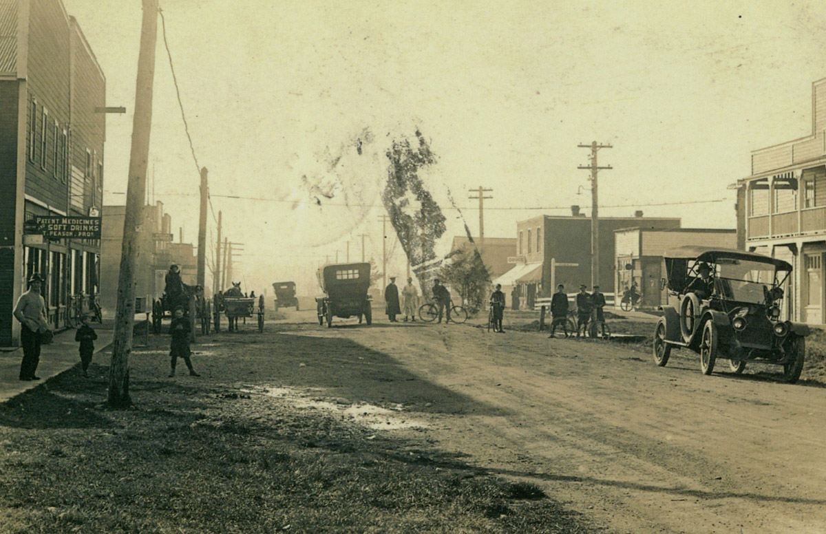
Sidney Museum & Archives 2011.12.1
ca. 1910s
This early photo of Sidney's Beacon Avenue was likely taken in the 1910s. It shows a busy street scene crowded with different transportation modes: early automobiles, horse-drawn buggies, pedestrians, and the extremely popular bicycle. The closest building to the right of the photo, on the north side of the street, was constructed in 1910 and held many different businesses over the years. The building to the left was the Berquist Block, which for several decades served as an important community gathering spot for Sidney.
* * *
It was the second storey of the Berquist Block that became a place for the community of Sidney to gather. This top floor became community hall of sorts, a place for clubs and organisations to meet and for dances and dinners to be held. The Berquist Block was also home to an extremely popular form of burgeoning entertainment: moving pictures or, as we know them now, movies. These brand new films were shown "every Tuesday and Friday Night at 7:30 p.m. sharp - Adults 25¢; Children 10¢”.1
The Berquist Block remained a community hub for several decades, but in 1928, tragedy struck and a fire destroyed the premises. The blaze was reportedly so bright that it could be seen for miles around, and it left behind nothing more than a few smoking timbers. Reconstruction work began within a month, but the replacement building was only one storey tall—there was no space for the type of community gatherings which the Berquist Block had held.
Other gathering spots had to fill the void left behind by the Berquist Block. The "Berquist's Small Hall", located directly across the street, held social events for many years, and in 1957, the Sidney and North Saanich Community Hall was officially opened. Just down the street on Fourth Avenue, the Berquist Picture Theatre opened in 1919 in a converted warehouse building and remained a popular entertainment venue for thirty years.
8. Sidney Businesses
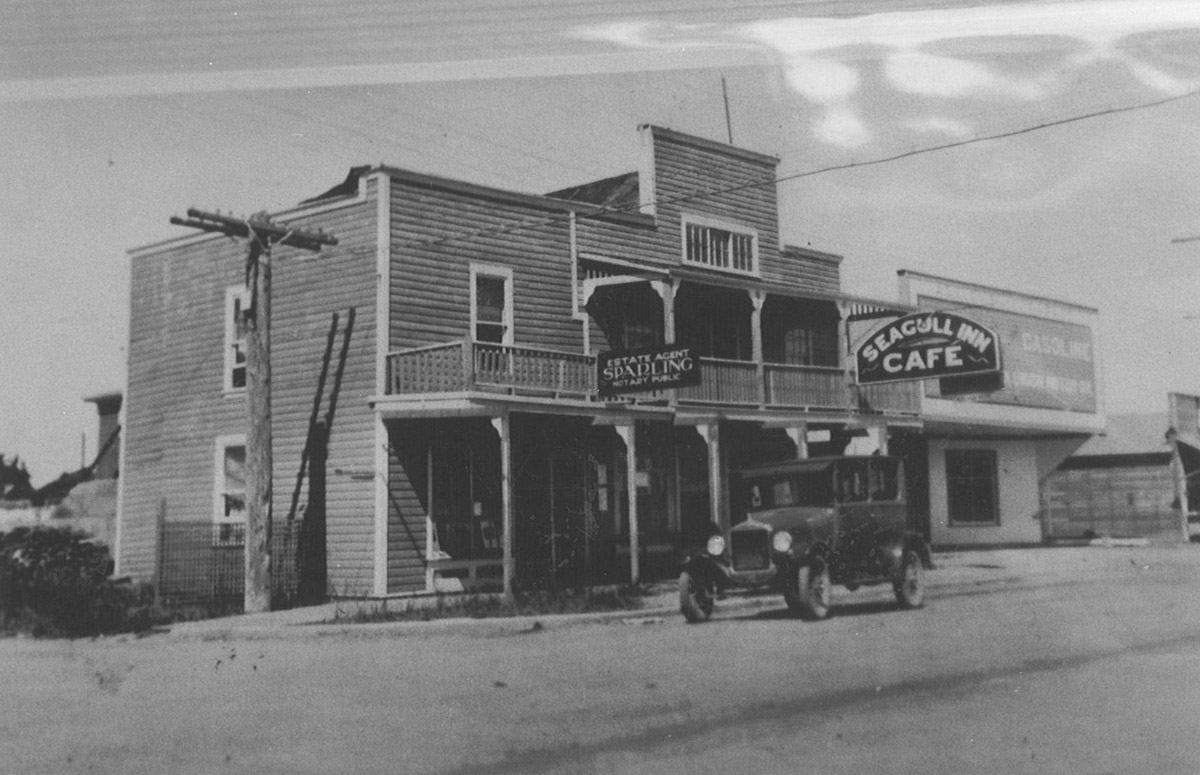
Sidney Museum & Archives P1993.36.1
1930
This photograph dates from 1930 and shows the popular Seagull Inn and Cafe, which was one of many businesses and buildings to operate on the northeast corner of Beacon Avenue and Fourth Street. Also pictured are the Sparling Real Estate offices, to the left, and a garage, to the right. A 1920s automobile is parked outside of the businesses. This corner has been home to a wide variety of local business ventures over the years, and its history offers a snapshot of Sidney's local economy throughout the twentieth century.
* * *
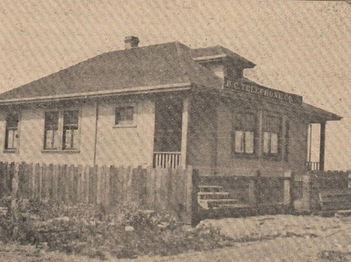
The corner on which you now stand was originally owned by teamster and livery man Andrew Munro, but was purchased by Andrew G. Berquist in 1910. Berquist, who had also purchased the lot on the other side of Beacon Avenue, built a two-storey building here and began to lease the bottom floor to the BC Telephone Company.2 Within two years, however, the telephone network had expanded, and larger premises were needed. The building on this corner evolved to different purposes, and over the course of the next decade, it served as a temporary high school, a community gathering spot, offices for the BC Electric Company, and the Flying Line stagecoach waiting room. This diverse set of businesses was only the beginning for this site, which would go on to host a dozen more throughout the early years of the twentieth century
The next new venture to take over the space was Mrs. Wesley Cowell's dressmaking shop in 1920, followed by Mrs. E. Davidson's roominghouse and restaurant in 1922. In 1926, the Speedie family opened the Seagull Inn and Cafe, pictured above, which remained at this location until 1931, when it became the Avenue Cafe. It narrowly escaped a disastrous fire in 1929 during which three nearby businesses were destroyed, but unfortunately in 1943, its luck ran out.. Flames destroyed both the cafe and a bus depot which also resided in the building.
In the aftermath of the fire, Frank L. Godfrey, owner of the Avenue Cafe, slowly rebuilt. In 1946, Godfrey opened a new business in the spot, known as Frank's News & Smokes and the Vancouver Island Coach Lines Depot. In the spring of 1962, Godfrey retired and sold his building to the Saanich Peninsula Credit Union, ending a rare sixteen-year period during which a local business had changed neither hands nor purposes. The credit union remained in the spot for only eleven years and was replaced by the store Colour Your World, and then by Carr's Toy Store in 1978 and the Sidney Toyland in 1979. In 1982, Tanner's Bookshop opened in this location, ending 72 years during which the location had changed hands and purposes no fewer than seventeen times. The bookstore became a familiar fixture of Beacon Avenue and has remained largely unchanged ever since.
9. Sidney's Chinatown
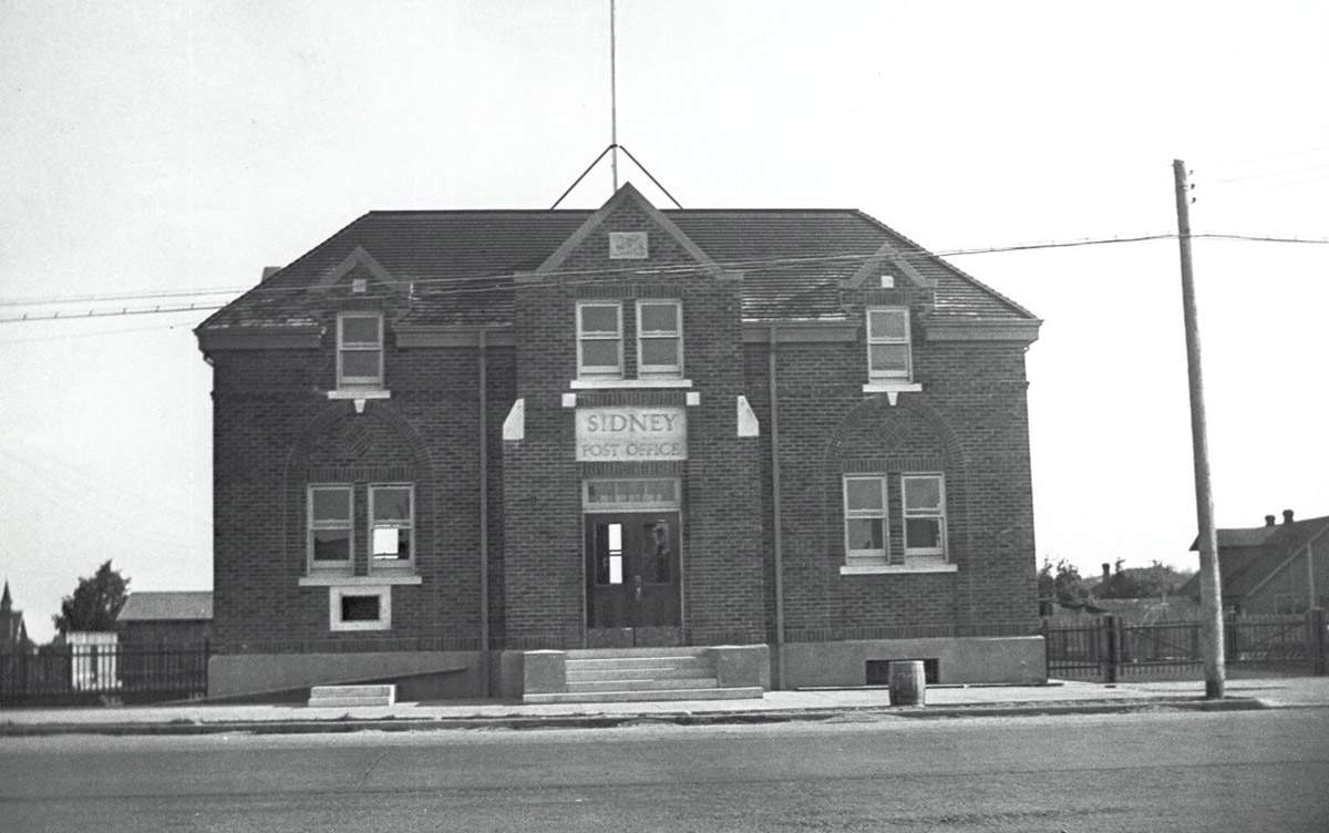
Sidney Museum & Archives P1993.35.17
ca. 1930s
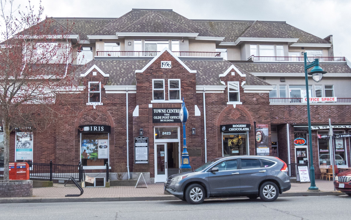
This photo from the late 1930s shows the Sidney Post Office on the south side of Beacon Avenue near Fourth Street. This post office, built in 1936, was constructed on the site of an important community which once stood in this spot between Fourth and Fifth Streets along Beacon Avenue. While no trace of it remains today, Sidney was once home to a small but bustling Chinatown. Its history has been largely forgotten, buried beneath Eurocentric history, stories, and records of the predominantly white European inhabitants of the town. Yet at the time, the community of Sidney's Chinatown provided a safe haven and a home for newcomers to Canada who were just starting to build lives for themselves in a foreign, strange, and often unfriendly new environment.
* * *
Census data from the period does provide some clues; there were 34 Chinese Canadian immigrants recorded as living in Sidney in 1901. This number rose to 124 by the 1911 census, which made up a quarter of the town's overall population..3 Many Chinese immigrants worked and lived in this single block of the town where we now stand. Choug Sing and Choug Feue were the first to set up a business in this area when they purchased the corner block on Fifth Street from Julius Brethour in the fall of 1905. Over the following six years, other Chinese Canadian businesses sprung up along this block, and by the 1910s, five out of the six building lots on this block of Beacon were owned by Chinese merchants.4
Like many of the early buildings which sprung up in communities across Canada at this time, the buildings which housed Sidney's Chinatown were built quickly out of inexpensive materials. They were two storeys tall and had large false fronts that hid the rough and ready nature of their construction. Business took place in the front of the buildings, while at the rear, small rooms were each home to several Chinese men. The buildings all had muddy backyards contained by high fences, where animals such as chickens, ducks, and pigs roamed.
Many Chinese immigrants, who were almost exclusively male due to Canada's restrictive immigration laws, worked as labourers at the nearby Sidney Sawmill or at the North Saanich Brick and Tile Co. There were also two laundries located along Beacon Avenue where we now stand, along with two general merchant stores, that of Kwong Lee Yuen and Chung Lee Lung. A prominent Chinese Canadian businessman from Victoria, Lim Bang, also owned a brick factory near Sidney, at Bazan Bay.5 For several decades, this community remained an important part of the fabric of Sidney life, but change was coming, and Chinatown would not be a part of Sidney forever.
10. Chinatown's End
Sidney Museum & Archives P1984.17.2
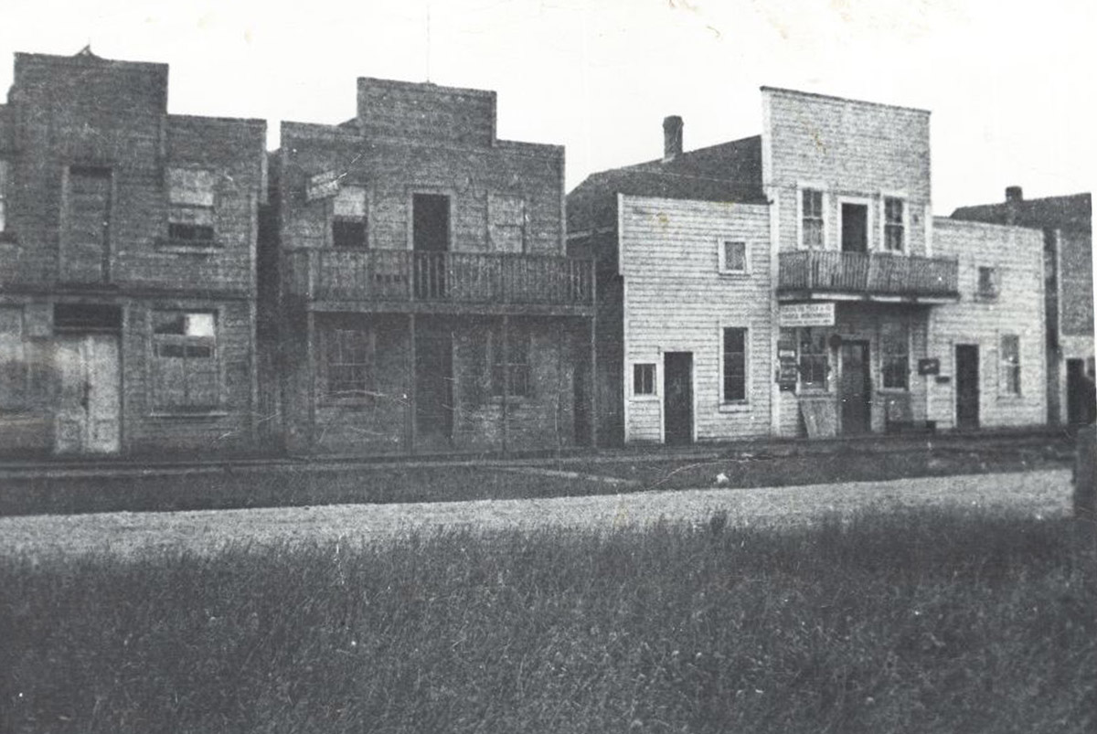
1914
This photo from 1914 is one of few in existence that shows Sidney's Chinatown. Note the false fronts on the wooden buildings, designed to provide a more polished exterior to the businesses. While for several decades, these buildings were the nuclei of the Chinese Canadian community in Sidney, their time on Beacon Avenue was short. The Chinese men who lived here would soon be drawn away by the pull of Victoria's Chinatown, which offered a larger, more vibrant Chinese Canadian community, with more jobs and a deeper connection to home and culture. Life within a small, mostly white settler town was not always easy for the Chinese Canadian immigrants, and the bigger city provided greater shelter from racism and exclusion.
* * *
Sidney's Chinatown also gained a reputation for criminal and illegal activity, although whether this reputation held truth is dubious. In one instance, a rumour spread that the back of Chung Lee Lung's business was home to an illegal gambling and drug ring, and Sidney's police raided the establishment several times. Sometimes, they found nothing. At other times, they found supplies of drugs and liquor, all of which Chung Lee Lung denied having any knowledge of.3 The raids and rumours did nothing to ease the relationship between the Chinese Canadian community and the rest of Sidney, perpetuating the idea that Chinatown was a dark, mysterious and criminal place.
Historically, opium has been tied to the Chinese community by white societies, but the reality is more complex. Opium was legal in Canada until 1908, when the Opium Act was passed, and in fact, in 1839 and in 1856, Great Britain went to war with China to secure access to the opium trade, from which they greatly benefitted.. It was only later that anti-Chinese sentiment in the colonised world began to turn public opinion against opium, branding it as "'inherently foreign' and dangerous—linked to Chinese men—and a threat to white, moral, Christian society".4
The banning of opium in 1908 in Canada followed on the heels of anti-Asian race riots in cities like Vancouver. Suddenly, a trade which before had been legal and highly lucrative among both Chinese immigrants and white settlers became criminalised. Raids like that of Chung Lee Lung's business became commonplace, and legislation like The Opium Act justified racist and discriminatory behaviour against Chinese Canadians. 5
The end of Sidney's Chinatown was influenced by several factors. The closure of the Sidney Sawmill in 1934 led to many Chinese immigrants facing unemployment, and the nearby city of Victoria offered greater opportunities. Simultaneously,by the 1930s, the majority culture of Sidney had branded Chinatown as "a general eyesore"6 When a new post office was needed in 1936, the site of Chinatown was chosen, and the buildings which had stood there for decades were torn down.. Sidney's Chinatown was no more, and in the following decades, it was all but erased from the town's history save for fragmentary descriptions, names, and places; A little talked of, little recorded past.
11. Sidney's Telephone Line
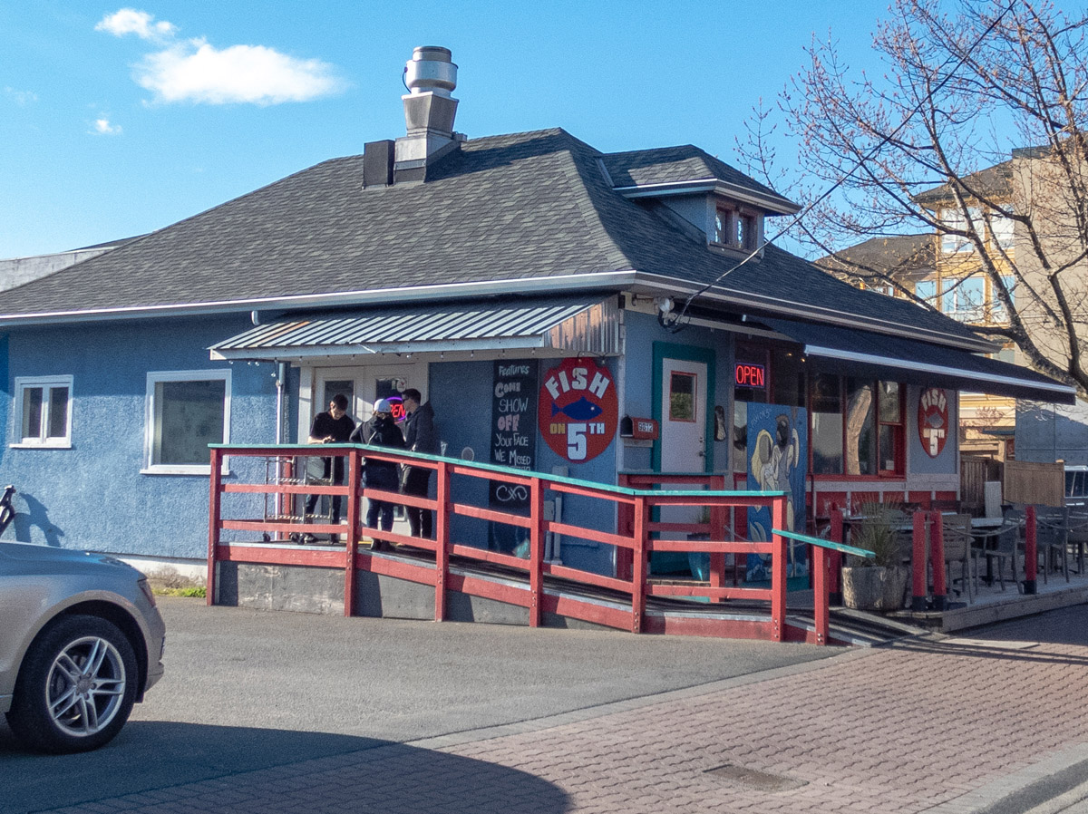
ca. 1920s
The building in front of which you are standing now houses the Fish on Fifth restaurant but is in fact one of the oldest buildings still remaining in Sidney. It began its life as the office for Sidney's telephone exchange in 1912 and served that purpose for several decades. In 1959, the development of new communication technologies led to the closure of the office, and the building was purchased by the Harkers to serve as Ruth Harker's beauty salon. The salon remained open until the early 1970s, and the building has since served several different purposes before becoming the well-known seafood restaurant Fish on Fifth.1 The history of Sidney's telephone line is one which illustrates the rapid changing of technology throughout the twentieth century.
* * *
The technology caught on, and by 1910, the BC Telephone Company had opened a telephone exchange office on the northeast corner of Beacon and Fourth Street. This first exchange had 53 subscribers, and the job of the telephone agent, James McNaught, was to make sure that subscribers could get calls through to anyone else on the line. Users would call the exchange, and McNaught would connect them to the line of the person to which they wanted to speak. It was an important job, and as the popularity and accessibility of the telephone grew, so too did the exchange. By 1912, the office was relocated to this spot, at Fifth and Beacon, with a 100-line switchboard and the capacity to expand to a 200-line board in the future. A second exchange with 35 subscribers was also opened in 1911 at Keatings.3
The new exchange was also the home of the new agent, Miss Sewell, who took over the job after McNaught resigned. In the early days of the twentieth century, the role of a telephone agent was one of the few jobs considered socially acceptable for women to work outside of the home. While the profession began as a male-dominated one, operators discovered that female agents were more likely to remain focused on the job and were therefore less likely to leave callers waiting: "when some other diversion held their attention, [male operators] would leave a call unanswered for any length of time, and then return the impatient subscriber’s profanity with a few original oaths."4 Young girls and women were recruited to the job en masse, and soon enough, female telephone agents such as Sewell were an accepted and normal part of the evolving world of technology.
Sidney's telephone network continued to grow as the twentieth century progressed. By the spring of 1922, the network had 165 subscribers, and by 1958, there were 1,656 subscribers.5 The telephone had become a normal part of everyday communication, and by the late 1950s, there were as many as 20 telephone agents working in Sidney’s exchanges.. By 1959, however, the age of the telephone agent had largely come to an end. Changing technology replaced manualtelephone operators with an automatic dial tone, and the telephone exchange was shut down. The building remains even today as a reminder of the Sidney of the past.
12. Taking to the Skies
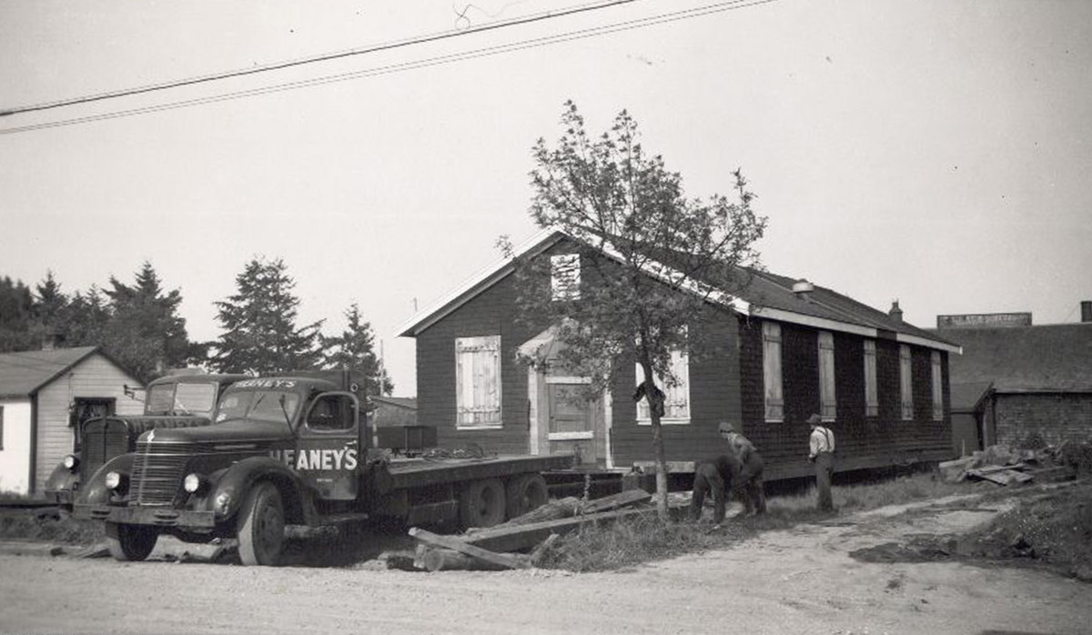
Sidney Museum & Archives P1981.8.8
1946
This picture is from 1946 and shows a former army hut from the nearby air force camp being moved into Sidney to serve as business premises for the Sidney Review. During the Second World War, Sidney was the neighbour of a bustling Royal Air Force Commonwealth Training School, and after the war came to a close in 1945, many of the buildings from this site were repurposed and moved into the town. In this photo, two trucks and several unidentified men take part in the transport of the large hut.
* * *
The base was also home to the Royal Air Force Commonwealth Training School between 1939 and 1942. This school trained approximately 10,000 servicemen from Commonwealth countries around the world during its operation, contributing significantly to Canada's war efforts.3 It was one of many such schools located across the country as part of the British Commonwealth Air Training Plan. Strategically, Canada was the perfect place to train members of the air force during the Second World War—the country was well out of the range of enemy aircraft, had an abundance of space to build training bases, and was near the United States, a major producer of aircraft during the war years.4 At Sidney's training school, pilots, navigators, and bomb aimers learned the crucial skills they would need to survive in Europe's embattled skies.
After the war, air force bases emptied out as the need for trained pilots waned. At first, government officials such as Major General George R. Pearkes, the Member of Parliament for the area at the time, suggested the deserted camps be used as housing for civilian families. Implementing this strategy proved complicated, however. The lease on the land at the airbase site was expiring, and it was not clear that utilities would be available in the long-term.. Instead, in 1946, the huts were put up for sale to be moved from their original locations.
During the following year, these huts were scattered across the region, becoming business premises, homes, garages, and storage facilities throughout the town of Sidney. They became so commonplace that in a 1947 article the Sidney Review wrote that "The thought persists…if our Army hut population grows, and their past association lingers, citizens of Sidney may be amazed at any time to see a line of ramrod-straight shopkeepers before their buildings standing at attention when little Jimmy inadvertently plays Inspection call on his bugle.”5
Sidney has changed a lot in the last hundred years, growing from a small village to a bustling, thriving town. It has evolved from a place of industry and agriculture to one of tourism and the service industry, developing a prosperous main road lined with bookstores, local businesses, and restaurants. But its history is still visible in old buildings, the view of the sea, and the histories and stories of people that laved lived on this land since time immemorial
Endnotes
1. The W̱SÁNEĆ People
1. "History & Territory." W̱SÁNEĆ Leadership Council, https://wsanec.com/history-territory/#.
2. "History & Territory." W̱SÁNEĆ Leadership Council.
3. Elliot, David Sr. Saltwater People, School District 63, Saanich, 1990.
https://wsanec.com/wp-content/uploads/2019/03/saltwater-people-1983-delliot-sr-compressed.pdf
4. "History & Territory." W̱SÁNEĆ Leadership Council.
5. "History of Sidney / SET,TINES." Sidney By The Sea, http://www.sidney.ca/About_Sidney/History_of_Sidney___SET_TINES.htm.
6. Elliot, David Sr.
7. Mandate & Constitution. W̱SÁNEĆ Leadership Council, https://wsanec.com/mandate/.
2. The Saanich Cannery
1. "The Saanich Cannery." Sidney Heritage Tour, https://sidney.maps.arcgis.com/apps/Shortlist/index.html?appid=6f5535a7b6014c57b08582b935863598
3. Industry's Rise and Fall
1. "Saanich Peninsula Timeline. Sidney Museum, https://sidneymuseum.ca/sidney-museum-history/.
2. "The Sidney Sawmill." Sidney Heritage Tour, https://sidney.maps.arcgis.com/apps/Shortlist/index.html?appid=6f5535a7b6014c57b08582b935863598.
3. "Sidney Rubber and Roofing Company." Sidney Heritage Tour, https://sidney.maps.arcgis.com/apps/Shortlist/index.html?appid=6f5535a7b6014c57b08582b935863598.
4. The S.S. Iroquois
1. "A Walk Through Time: Transportation, S.S. Iroquois." Sidney Museum and Archives, https://web.archive.org/web/20120223205714/http://www.sidneymuseum.ca/history-ferries-Iroquois.html.
2. Morrison, Brad. "Sinking of Iroquois Shocks Residents." Peninsula News Review, April 2011.
3. Morrison.
4. Morrison.
5. Founding a Town
1. "Brief History of the Town of Sidney." Sidney Heritage Tour, https://sidney.maps.arcgis.com/apps/Shortlist/index.html?appid=6f5535a7b6014c57b08582b935863598.
2. "Saanich Peninsula Timeline. Sidney Museum, https://sidneymuseum.ca/sidney-museum-history/.
3. "History of Sidney / SET,TINES." Sidney By The Sea, http://www.sidney.ca/About_Sidney/History_of_Sidney___SET_TINES.htm.
4. Margaret Horsfield and Ian Kennedy, Tofino and Clayoquot Sound: A History (Madeira Park: Harbour Publishing, 2014), 168.
5. "History of Sidney / SET,TINES." Sidney By The Sea.
6. "History of Sidney / SET,TINES." Sidney By The Sea.
6. The Victoria & Sidney Railway
1. "Victoria & Sidney Railroad." Victoria Harbour History,
https://www.victoriaharbourhistory.com/transportation/rail/esquimalt-nanaimo-railroad-2/.
2. "Victoria & Sidney Railroad." Victoria Harbour History.
3. "Saanich Peninsula Timeline. Sidney Museum, https://sidneymuseum.ca/sidney-museum-history/.
7. A Place to Gather
1. "The Berquist Building." Sidney Heritage Tour, https://sidney.maps.arcgis.com/apps/Shortlist/index.html?appid=6f5535a7b6014c57b08582b935863598.
8. Sidney Businesses
1. "Saanich Peninsula Timeline. Sidney Museum, https://sidneymuseum.ca/sidney-museum-history/.
2. "The 'Creme de la Creme' Corner." Sidney Heritage Tour, https://sidney.maps.arcgis.com/apps/Shortlist/index.html?appid=6f5535a7b6014c57b08582b935863598.
9. Sidney's Chinatown
1. John Lo, Michael, and An, Guoliang. "Victoria Chinatown." The Canadian Encyclopedia, March 2022, https://www.thecanadianencyclopedia.ca/en/article/victoria-chinatown.
2. “Gold Mountain”, Province of British Columbia, https://www2.gov.bc.ca/gov/content/governments/multiculturalism-anti-racism/chinese-legacy-bc/history/gold-mountain
3. "Chinatown." Sidney Heritage Tour, https://sidney.maps.arcgis.com/apps/Shortlist/index.html?appid=6f5535a7b6014c57b08582b935863598.
4. "Chinatown." Sidney Heritage Tour.
5. "Lim Bang." Victoria's Chinatown, https://chinatown.library.uvic.ca/index.htmlq%3Dlim_bang.html.
10. Chinatown's End
1. "Chinatown." Sidney Heritage Tour, https://sidney.maps.arcgis.com/apps/Shortlist/index.html?appid=6f5535a7b6014c57b08582b935863598.
2. "Chinatown." Sidney Heritage Tour.
3. "Chinatown." Sidney Heritage Tour.
4. "History of Drug Policy in Canada." Canadian Drug Policy Coalition, https://drugpolicy.ca/about/history/.
5. "History of Drug Policy in Canada." Canadian Drug Policy Coalition, https://drugpolicy.ca/about/history/.
6. "Chinatown." Sidney Heritage Tour.
11. Sidney's Telephone Line
1. "BC Telephone Company." Sidney Heritage Tour, https://sidney.maps.arcgis.com/apps/Shortlist/index.html?appid=6f5535a7b6014c57b08582b935863598.
2. Inflation Calculator, Bank of Canada, https://www.bankofcanada.ca/rates/related/inflation-calculator/.
3. "BC Telephone Company." Sidney Heritage Tour.
4. Dilts, Marion May. The Telephone in a Changing World, 1941.
5. "BC Telephone Company." Sidney Heritage Tour.
12. Taking to the Skies
1. "History." Victoria Flying Club, http://flyvfc.com/history.
2. Millar, Ceilidh. "WWII Airmen Killed in Training Honoured with Monument at Victoria Airport." Chek News, June 2017. https://www.cheknews.ca/wwii-airmen-killed-in-training-honoured-with-monument-at-victoria-airport-330021/
3. Millar, Ceilidh.
4. Hillmer, Norman, Hatch, Fred, and Myers, Patricia. "British Commonwealth Air Training Plan." Canadian Encyclopedia, 2006, https://www.thecanadianencyclopedia.ca/en/article/british-commonwealth-air-training-plan.
5. "First Army Hut Installed in 1945." Sidney Heritage Tour, https://sidney.maps.arcgis.com/apps/Shortlist/index.html?appid=6f5535a7b6014c57b08582b935863598.
Bibliography
Bank of Canada. "Inflation Calculator." https://www.bankofcanada.ca/rates/related/inflation-calculator/.
Canadian Drug Policy Coalition. "History of Drug Policy in Canada." https://drugpolicy.ca/about/history/.
\Dilts, Marion May. The Telephone in a Changing World, 1941.
Elliot, David Sr. Saltwater People, School District 63, Saanich, 1990. https://wsanec.com/wp-content/uploads/2019/03/saltwater-people-1983-delliot-sr-compressed.pdf
Hillmer, N., Hatch, F, & Myers, P. "British Commonwealth Air Training Plan." Canadian Encyclopedia, 2006. https://www.thecanadianencyclopedia.ca/en/article/british-commonwealth-air-training-plan.
Horsfield, Margaret and Kennedy, Ian Kennedy. Tofino and Clayoquot Sound: A History. Madeira Park: Harbour Publishing, 2014. .
John Lo, Michael, and An, Guoliang. "Victoria Chinatown." The Canadian Encyclopedia, March 2022, https://www.thecanadianencyclopedia.ca/en/article/victoria-chinatown.
Millar, Ceilidh. "WWII Airmen Killed in Training Honoured with Monument at Victoria Airport." Chek News, June 2017. https://www.cheknews.ca/wwii-airmen-killed-in-training-honoured-with-monument-at-victoria-airport-330021/
Morrison, Brad. "Sinking of Iroquois Shocks Residents." Peninsula News Review, April 2011.
Province of British Columbia. “Gold Mountain.” https://www2.gov.bc.ca/gov/content/governments/multiculturalism-anti-racism/chinese-legacy-bc/history/gold-mountain
Sidney Museum and Archives. "A Walk Through Time: Transportation, S.S. Iroquois." https://web.archive.org/web/20120223205714/http://www.sidneymuseum.ca/history-ferries-Iroquois.html.
Sidney Museum & Archives. "Sidney Digital Heritage Tour." https://sidney.maps.arcgis.com/apps/Shortlist/index.html?appid=6f5535a7b6014c57b08582b935863598.
Sidney Museum and Archives "Saanich Peninsula Timeline." https://sidneymuseum.ca/sidney-museum-history/.
Town of Sidney."History of Sidney / SET,TINES." Town of Sidney, http://www.sidney.ca/About_Sidney/History_of_Sidney___SET_TINES.htm.
Victoria's Chinatown. "Lim Bang." https://chinatown.library.uvic.ca/index.htmlq%3Dlim_bang.html.
Victoria Flying Club. "History." http://flyvfc.com/history.
Victoria Harbour History. "Victoria & Sidney Railroad." https://www.victoriaharbourhistory.com/transportation/rail/esquimalt-nanaimo-railroad-2/.
W̱SÁNEĆ Leadership Council. "History & Territory." https://wsanec.com/history-territory/#.
W̱SÁNEĆ Leadership Council. "Mandate & Constitution." https://wsanec.com/mandate/.