Walking Tour
A Cycling Odyssey
Perry Doolittle's Pioneering Journey
Ian McKechnie
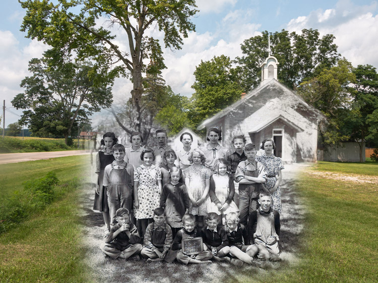
Aylmer-Malahide Museum and Archives 2000-009-0021
Born in 1860, Doolittle took up cycling at eighteen and within a few years had built himself a couple of crude bicycles on which he cycled from Aylmer to Strathroy, a distance of 50 miles. In 1881, he became a founding member of the Canadian Wheelman’s Association, an organization known today as Cycling Canada. By the turn of the twentieth century, Doolittle’s interests had expanded to automobiles, and he went on to organize the Dominion Automobile Association in 1913.1
This cycling tour through Doolittle’s old stomping grounds of Malahide Township how much has changed over the course of more than a century. Horse-drawn vehicles gave way to automobiles, and local towns, villages, and hamlets had to accommodate them. What was once popular in the realm of fashion and architecture changed as the new century progressed, and local agrarian-based economies were forced to adapt or wither as technology evolved with the times.
In the spirit of Perry Doolittle, mount your bike and let’s get going. This fourteen-stop tour will take you through long-gone hamlets, past houses great and small, and along picturesque country roads where, despite appearances, change is often the only constant.


This project was completed in partnership with the Elgin County Museum & Archives.

1. The McNichol House
1910
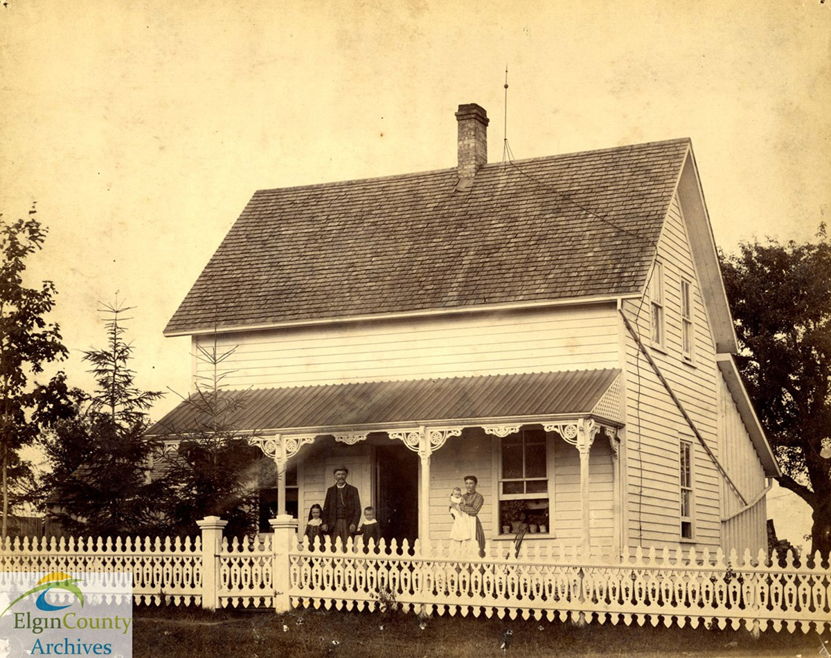
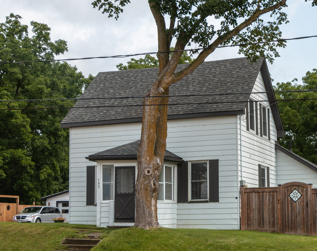
The main thoroughfare through Belmont is significantly busier than it was in the 1890s, when cycling enthusiasts first pedalled their penny-farthings and safety bicycles around town – or out into the country. As they cruised south along Belmont Road (now County Road 74), they would have passed a little white dwelling known for years as the McNicol House.
* * *
Tastes changed considerably in the decades following the Second World War. Just as cyclists exchanged the formality of the 1890s for the comfort of later fashion choices, so did residents of older houses take steps to modernize their properties.2 Today, the McNicols would scarcely recognize their old house. Gone is the grand porch, replaced with an enclosed vestibule. The fence has long since come down, and the back of the house has been completely rebuilt.
Evolution – whether in architectural tastes or transportation – is a hallmark of Malahide Township’s rich history, something that we will see time and again on this tour.
2. C.P.R. Station, Belmont
1905
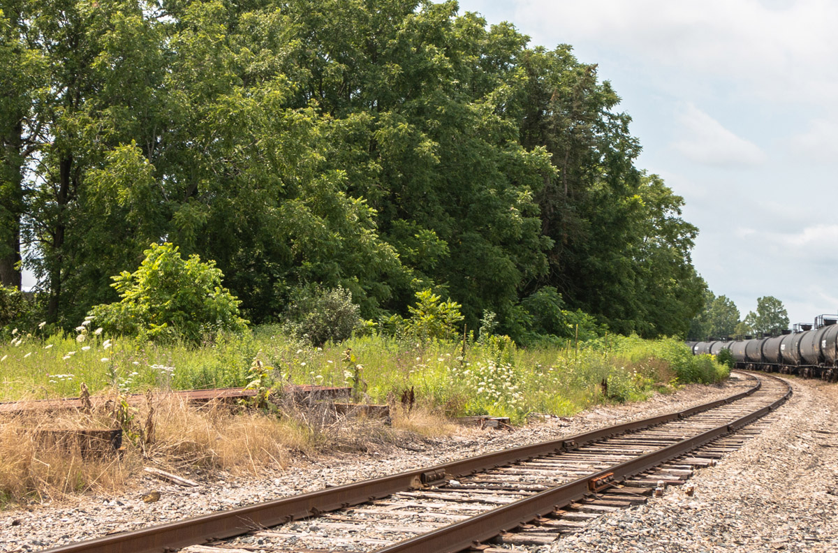
The raucous blast of an air horn sounds in the distance as one of the Ontario Southland Railway’s maroon and cream-coloured locomotives rounds a bend in front of what was once Belmont’s bustling railway station. A string of black tank cars waits to be switched off the spur track adjacent to Belmont Farm Supply, one of several industries between St. Thomas and Woodstock that have depended on train service provided by the OSR since 2009.1 The trains today may not be so numerous, but they still pass through Belmont from time to time, so take note of your surroundings as you cycle over the rails crossing Belmont Road.
* * *
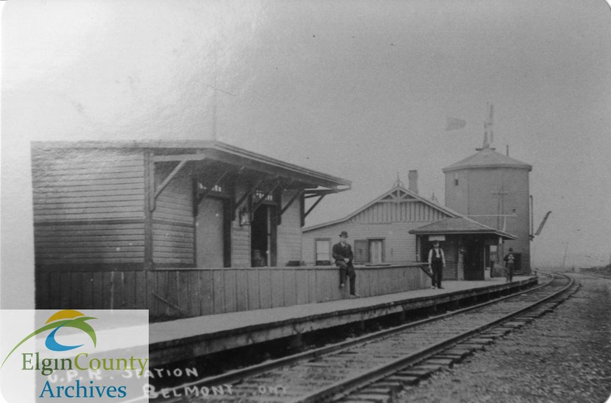
Like most stations built under Canadian Pacific Railway auspices throughout the last quarter of the nineteenth century, that in Belmont was simple and unadorned in appearance.2 A long and low gabled roof overhung the platform and operator’s bay window, which afforded unobstructed views of the track in either direction. Originally designed as a wood frame building in the "stick style," the station was later covered over in the insulbrick siding popular from the 1950s onward.
Bookending the station proper were two structures common to many small-town station sites: the freight shed and the water tank. As of 1905, the latter was an octagonal tower built from wood; it was later replaced with a steel tank. By 1960, most of Canada’s railway system had substituted diesel locomotives for the once-ubiquitous steam engine and the water tanks were rendered obsolete. The station itself closed after passenger service wound up in 1957, and was moved to the corner of Belmont Road and Ron McNeil Line where it served as a private residence for some years thereafter.
For years, the Belmont Station was a hive of activity, and residents young and young-at-heart would pedal up to the station grounds, lean their bicycles against the building, and wait for the train to arrive.2 Today the site is obscured by foliage and long grass, but memories of train time from years gone by live on in the recollections of those who were brought up in Belmont.
3. Lyons General Store
1918
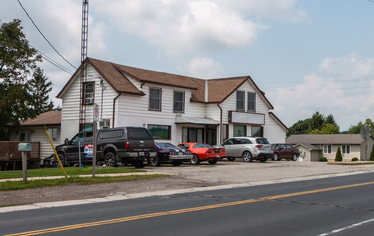
As you approach the intersection of Imperial Road and Lyons Line, consider what a cyclist 120 years ago might have needed while out on his or her journey. Perhaps a chain or sprocket needed some oiling, or the individual doing all of that pedalling needed a bite to eat or a cool drink to sustain them on the remainder of their trip. For these hearty cycling enthusiasts, the sight of a general store at a crossroads like Lyons came as a welcome relief.
* * *
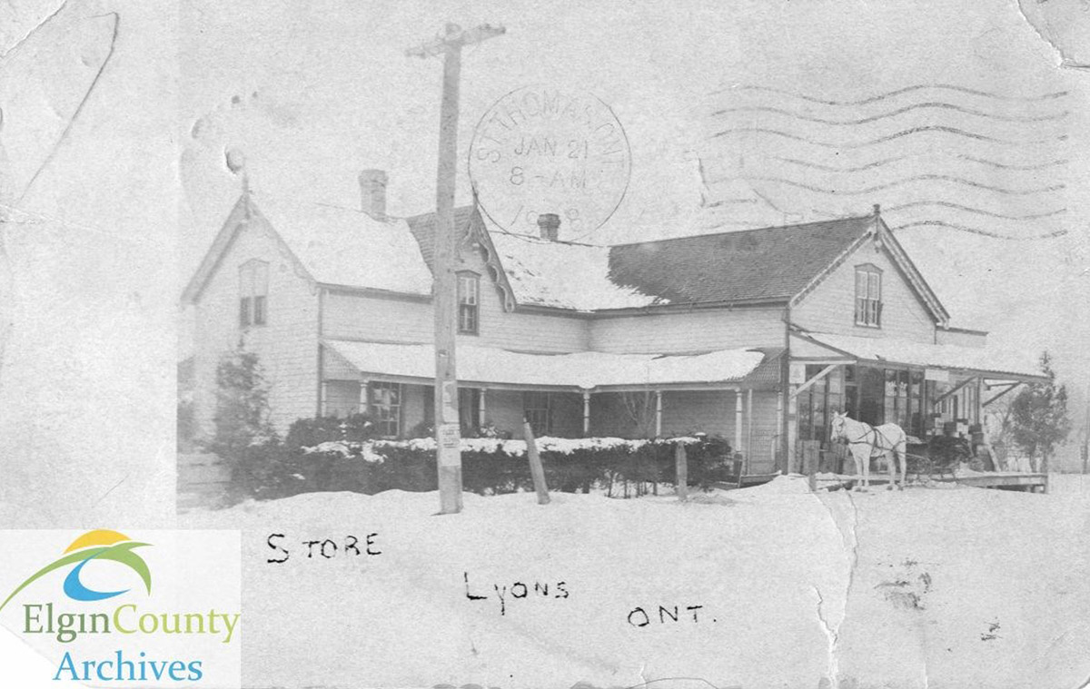
Lyons had a general store as early as 1854, when W.T. Waugh was listed as the storekeeper. Noah Lee had assumed the storekeeper’s responsibilities by 1865, and the current building was constructed in the 1870s by Thomas H. Winder and Isaac Baker. As of 1907, Mr. Winder was listed as both the storekeeper and postmaster – a role that saw him process Lyons’ incoming and outgoing mail before the advent of rural mail delivery. From 1926 through 1961, the store was operated by Lorne and Hazel McCallum, and as of 1980 was being overseen by George Klein.2 Quite apart from managing a business, the rural storekeeper was also the source of local news and was often the first to hear about births, deaths, and other events affecting the lives of his or her customers.
By 1980, Lyons had long since lost its once-prominent brickyard and cheese factory. Only a few businesses remained, of which the old store was one. Lyons, like many hamlets in rural Ontario, owed its decline to the private automobile. No longer did farmers and other local residents have to restrict their shopping to the store down the road, not when they could drive into Belmont or Aylmer.
The Lyons general store lasted into the twenty-first century, and closed after 2010. Now a private residence, it has been substantially remodelled and only traces of the building’s original appearance can be discerned. A sign that once read "Lyons Variety" overlooks the asphalt lot outside, the last vestige of this building’s crucial role in the life of Lyons.
4. Main Street, Springfield
1925
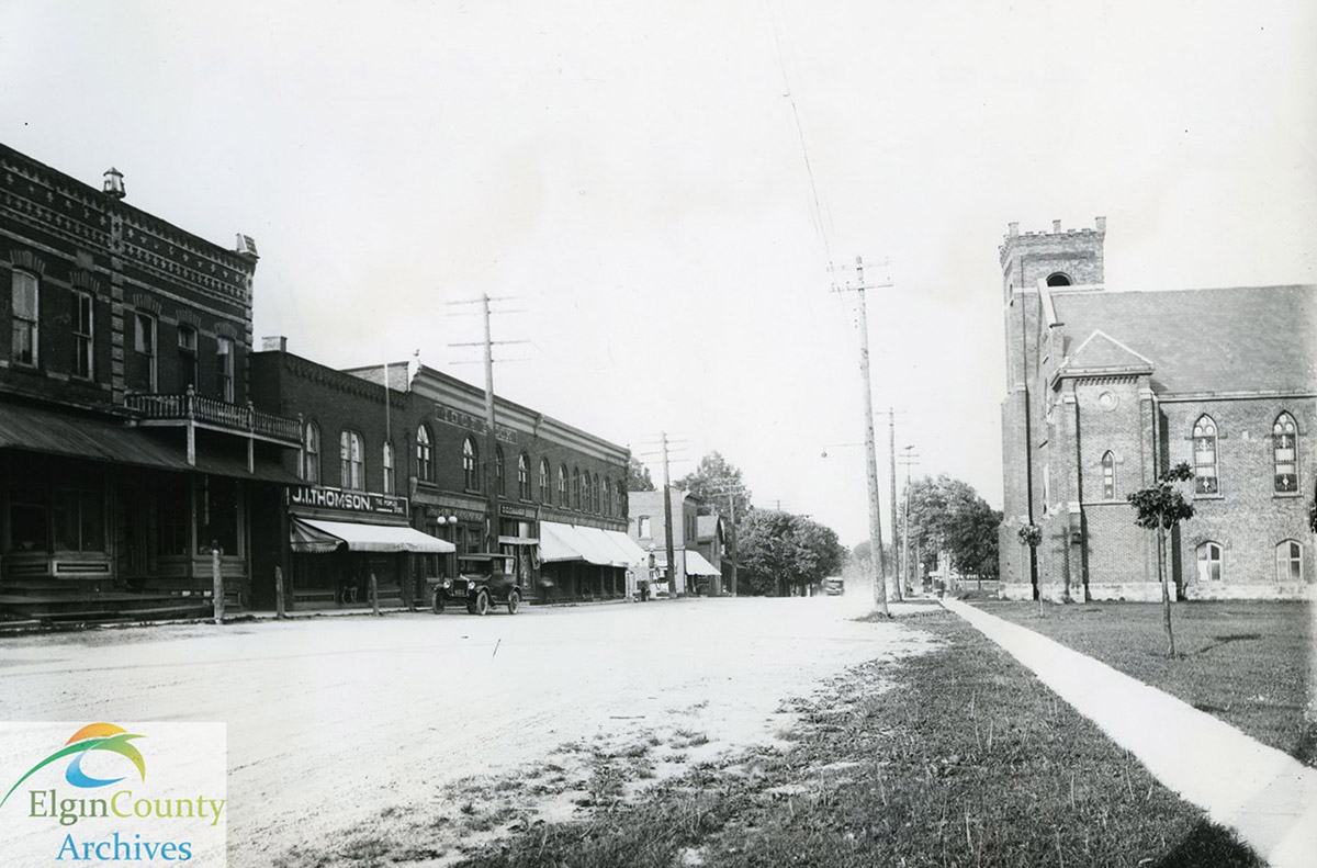
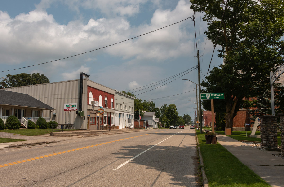
Ontario’s downtown main streets served several purposes. First and foremost, they functioned as a community’s commercial core. Those engaged in the professions – law and medicine, for instance – set up shop alongside merchants who sold everything from dry goods to hardware. Through their exquisite architecture and vibrant atmosphere, Ontario’s main streets reflected a community’s self-confidence and enticed visitors to stay awhile.
Springfield’s Main Street, now known as Ron McNeil Line, scarcely differed from its peers in these respects. Incorporated as a village in 1878, Springfield’s prosperity owed much to the Canada Southern Railway, which in 1873 opened a station a couple of blocks to the south.
* * *
Whether walking or cycling, you will discern noticeable changes in Springfield’s streetscape. Commercial blocks a century old abut new development, and Edwardian-era facades have been obscured by new signage. Main Street is no stranger to the forces of change – or wind-fanned flames. On May 29, 1902, a fire erupted in a stable behind Atkin’s butcher shop. It soon grew in proportions and obliterated virtually everything on the north side of the street. When the smoke finally subsided, half a dozen businesses were faced with the prospect of rebuilding, as was St. John’s Methodist Church.2 Mac M. Black’s insurance firm no doubt did stellar business in the wake of the fire!
By 1925, when St. John’s became part of the United Church of Canada, Springfield’s Main Street was home to J.I. Thompson’s Dry Goods and Grocery store, a Royal Bank of Canada branch, D.C. Gillies’ store, and a block in which the Independent Order of Foresters had their meeting rooms.3
Although Springfield’s existence was still very much dependent on the traditions of an agrarian economy, modern developments were just around the corner – literally. A gas pump at the corner of Main Street and Whittaker Road in 1925 reminded residents and visitors alike that the days of getting around by buggy or bicycle were receding into the past. Motor vehicles making their way from St. Thomas to Tillsonburg and vice-versa were now the norm.
5. Glencolin Bridge
1913
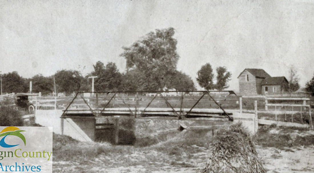
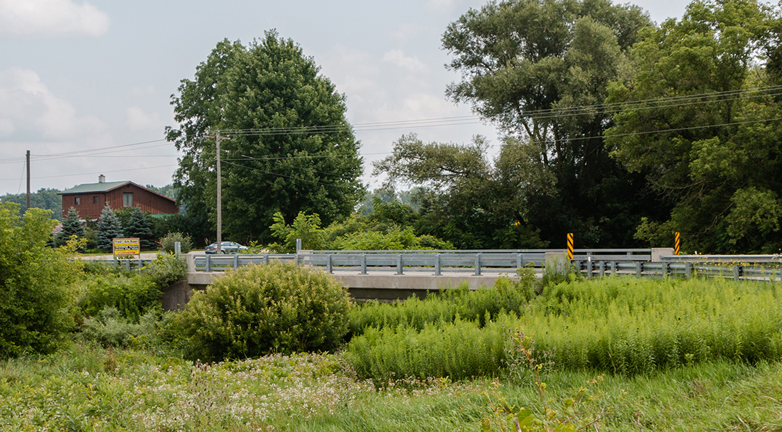
Southwestern Ontario’s rural geography tends to be the product of surveyor errors and idiosyncrasies dating back to the first half of the nineteenth century. Thus when you reach the intersection of Glencolin Line and Springfield Road, you will find that neither crosses the other exactly at a right angle. Rather, they briefly merge as they cross the Glencolin Bridge before going their separate ways.
* * *
Though the G.W.R. surveyors managed to avoid crossing the creek in Glencolin proper, a bridge was required for those crossing by horse-drawn vehicle, bicycle, and eventually automobile. At first, a wooden bridge was constructed by Messrs. Turnbull and Wickett, of Orwell. By 1913, this bridge had been strengthened by the addition of Warren-type trusses (a design originating in the United Kingdom in which the load was carried by equilateral triangles).3 It was replaced in 1939 by a concrete span that has since been rebuilt and widened to accommodate the requirements of twenty-first century traffic.
As you pedal over the Glencolin bridge, pause to consider the number of cyclists, pedestrians, and motorists who have made this same crossing. Much has changed in the surrounding landscape: Glencolin as Samuel T. Young knew it is long gone and railway service has dwindled. Yet this creek continues to twist and wind its way under the Glencolin Bridge, a testament to natural obstacles generations have sought to overcome through engineering ingenuity.4
6. Glencolin Cemetery
Aylmer-Malahide Museum and Archives 2019-033-0076
1950
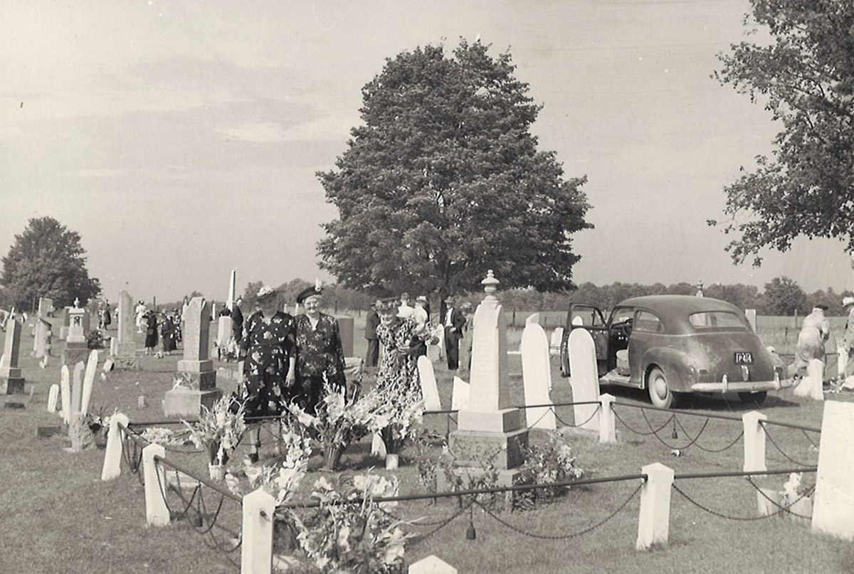
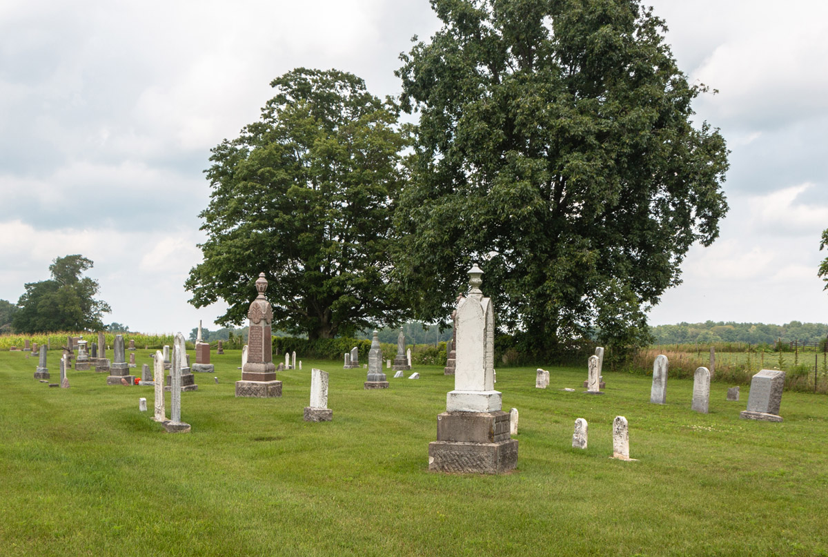
Traces of nineteenth century Ontario linger on in Mennonite country northeast of Aylmer. Farmhouses are not wired for electricity, and the clip-clop of passing horse-drawn buggies evokes an era when the conveniences and comforts we take for granted today was but a distant dream. Technological advances over the last 150 years have also enabled many once-fatal diseases to be treated, leading people to live longer and healthier lives. Visiting an old cemetery, therefore, can be a sobering experience, bringing one face to face with monuments to individuals who died too young.
* * *
Dismounting from your bicycle and strolling into the cemetery, be sure to take note of the inscriptions on the monuments. Time and the elements have made it difficult to make out words on the ancient marble headstones – yet these dates, personal names, place names, and bits of verse have much to tell us about the culture and worldviews of those interred here. Many of the markers also face east, reflecting an ancient belief in which the dead will be raised at the dawn of a new age.3
It is fitting that we conclude our tour at a rural cemetery such as that east of Glencolin. They are the epitome of permanence. Despite changes in the materials and customs used to memorialize the dead, the cemetery urges us to remember that death is common to every generation. The surrounding landscape – and the technology we use to interact with it –might undergo change, but cemeteries steadfastly remain anchored in shared human experience.
7. Luton School (S.S. No. 8 Malahide)
Aylmer-Malahide Museum and Archives 2020-015-0001j
1939
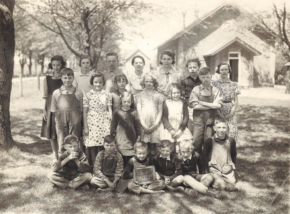
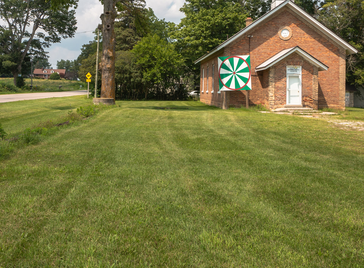
Upon reaching the corner of John Wise Line and Hacienda Road in the village of Luton, travellers encounter one of rural Ontario’s most ubiquitous and fondly-remembered institutions: a one-roomed schoolhouse. This stately red-brick edifice served the students of School Section No. 8 in Malahide Township for ninety years and remains in use as a community hall.
* * *
A single teacher was responsible for providing education to eight grades of students, who had an enormous schoolyard at their disposal in which to enjoy recess. After spending several hours at a desk in reading, writing, and arithmetic, the opportunity to play ball, marbles, tag, and various other games was relished by those enrolled at S.S. No. 8 Malahide. Among those who attended school here during the brick school’s first few years in operation was one Dr. Roland Hill (1868-1956), who later moved to Missouri and worked as a surgeon.2 By 1939, the student population was close to twenty.
Ontario’s education system faced new challenges by the 1950s. Many of the old one-room schoolhouses were becoming overcrowded, and educational philosophies were changing. Improvements in transportation also played a role in making the schools obsolete. School buses could carry vast numbers of students from across several school sections to a consolidated school in a centralized location.3 In 1965, S.S. No. 8 Malahide was closed and students were sent to Malahide Township Public School, which has since been renamed Summer’s Corners Public School.
8. Dunboyne Cheese Factory
1913
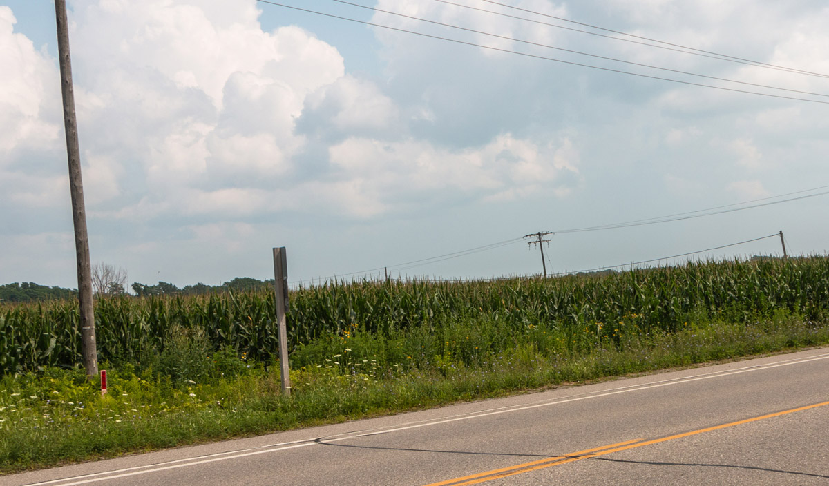
During the late summer, many Ontarians relish the taste of fresh corn on the cob – something that will surely come to mind as you cycle past the vast cornfields in Dunboyne. Of course, no corn roast is complete if a cob isn’t first rolled through a dish of melted butter.
* * *
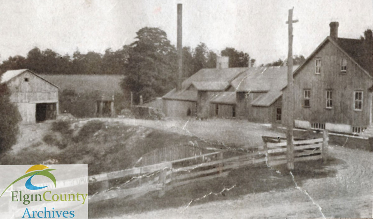
Wardell’s cheese factory enjoyed a considerable amount of business during the first decade of the twentieth century. On February 27th 1908, The Aylmer Express reported that over 100 tons of cheese had been produced over the previous year, with $25,447.77 being generated in income. "Mr. John Wardle [sic], the popular and efficient cheesemaker has the confidence of the patrons and is worthy of it," said the Express in its coverage of the Dunboyne Cheese Company’s annual meeting. Apart from reviewing production figures at that 1908 meeting, the men in charge of the operation listened to a Mr. Travis address the group on the subject of pasteurizing whey.2
Somewhat ironically, not every activity transpiring in Dunboyne’s cheese factory involved cheese. On January 15th 1908, it hosted the Dunboyne and Copenhagen Beef Ring’s annual oyster supper (a beef ring is a cooperative endeavour in which members supply one animal annually to the cooperative). About ninety people gathered in the curing room for sandwiches, cake, and oysters while enjoying music provided by both a phonograph and live instrumentalists. In providing a venue to community organizations such as the beef ring, the cheese factory engaged in its own form of public relations. As The Aylmer Express put it on January 23rd 1908, "Many who had never visited the Dunboyne cheese factory before were surprised to see so spacious a curing room with its cement floors and walls as clean and sweet as a queen’s kitchen."3
Until the 1980s, it was still possible to see a dirt lane terminating in the mound of earth that once supported Dunboyne’s cheese factory, which had been destroyed by fire decades earlier. This earthen mound was later ploughed over and today no evidence remains of this once-vital part of Dunboyne’s economy. Cheesemaking, meanwhile, benefited from changes in technology and transportation that enabled milk to be shipped longer distances to larger production facilities. With the disappearance of the local cheese factory, rural Ontario lost one more of its agricultural landmarks.
9. Thayer's Gas Bar
1940
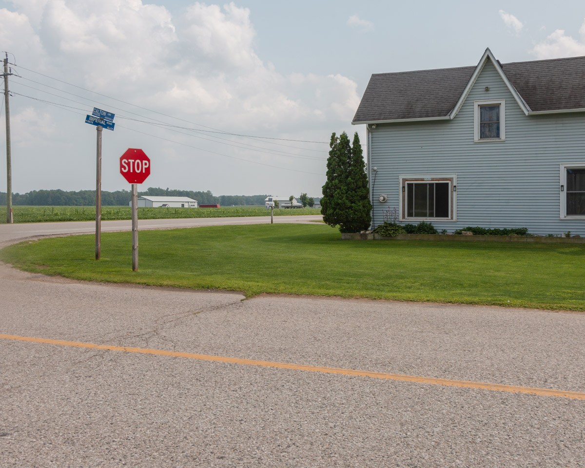
Approaching the southwest intersection of Calton Line and Imperial Road brings you face to face with what, on first glance, looks like little more than a vernacular farmhouse surrounded by a neatly-manicured lawn. Cornfields dominate the other three corners, and the smells of farm country commingle with exhaust fumes as cars and trucks fly by this busy intersection.
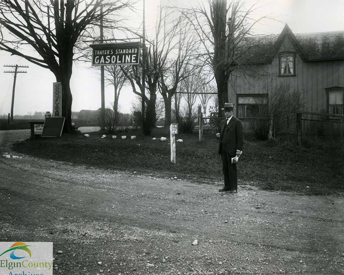
Eighty years ago, motorists making their way through this part of Malahide Township might have pulled up beside this farmhouse and waited while an attendant refuelled their cars with gas, pumped up a flat tire, or sold them a cold drink. Back then, this erstwhile board-and-batten building wasn’t merely a residence – it was a roadside service station known as Thayer’s Gas Bar.
* * *
An unidentified photographer captured a dapper-looking Mr. Thayer standing in front of the gas station around 1940. Towering over a 1930 or 1931 Ford Model "A" sedan in the background were two visible gas pumps. Gasoline was pumped into a glass cylinder atop the pump prior to entering a car’s fuel tank, a system that enabled a motorist to determine how much gas was being purchased. Like many roadside service stations, Thayer’s Gas Bar supplemented its gasoline sales with other products, including Goodyear tires and light refreshments.
Starting with this modest facility, Herb Thayer came to own and operate a number of gas stations throughout Elgin County.2 Ironically, Thayer’s expansion of his petroleum business foreshadowed the eventual disappearance of the little gas station on the corner of Calton Line and Imperial Road. Major petroleum producers consolidated operations throughout the second half of the 20th century, and as automotive design evolved, it became unnecessary to stop for gas every few miles.3 Motorists could wait until reaching Port Bruce or Aylmer before filling up.
Though the "Thayer’s Standard Gasoline" signage and Art Deco-looking gas pumps are long gone, this charming house in Dunboyne remains – reminding passersby of a time when the automotive business cast a long shadow over even the smallest of southwestern Ontario’s communities.
10. Amasa Lewis House
ca. 1940s
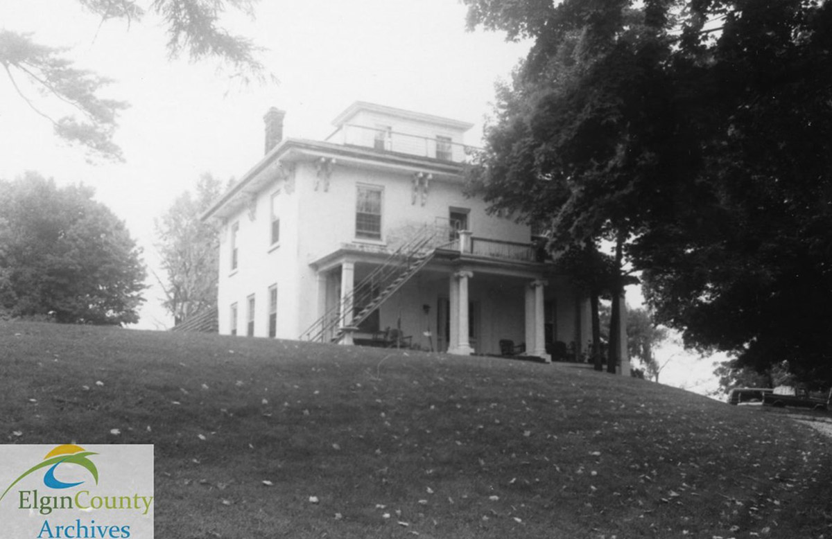
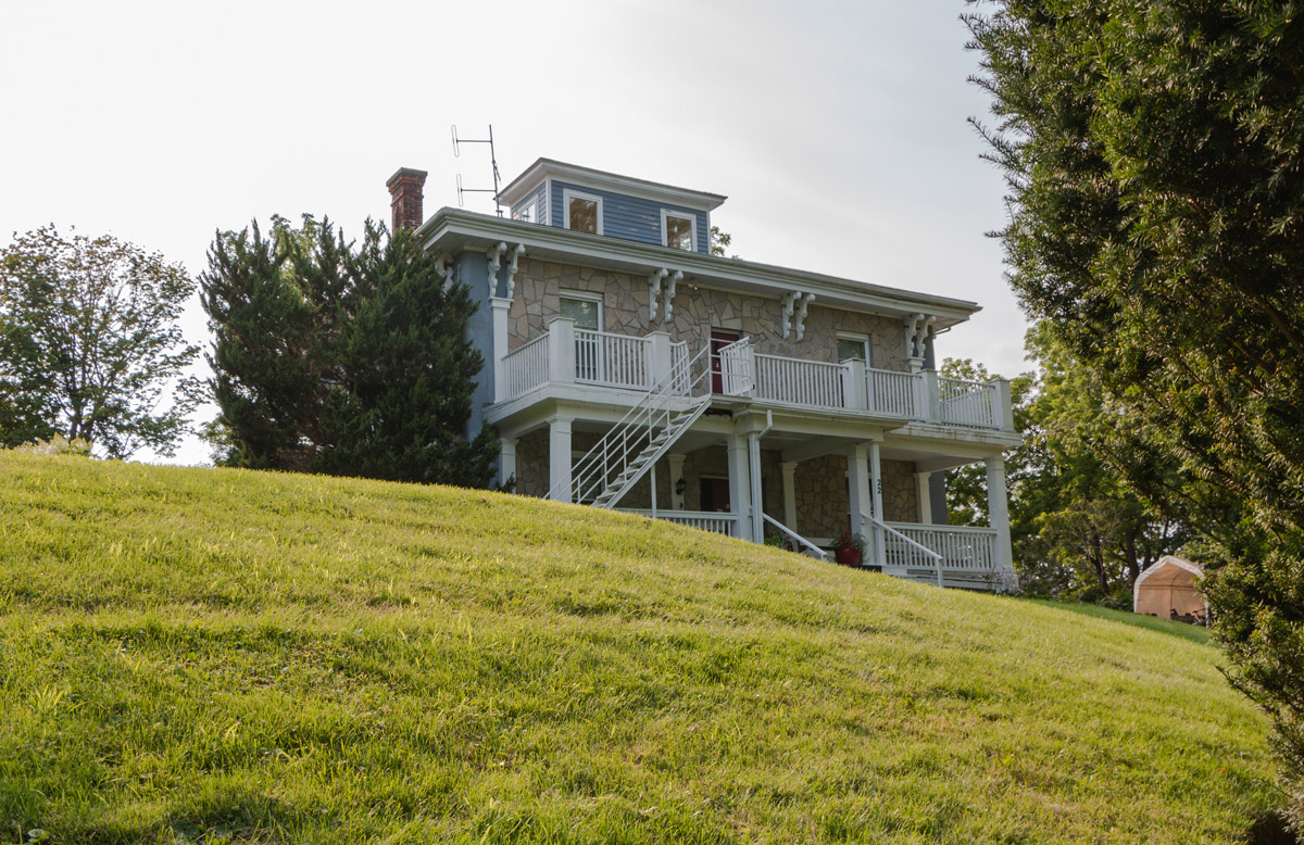
The industrial revolution as it played out in Ontario produced many magnates from the mid-nineteenth century onward. Individuals engaged in lucrative business or financial ventures were not slow to showcase their wealth by building mansions in prominent locations in rural and urban settings. Sir Allan Napier McNab’s Dundurn Castle in Hamilton comes to mind, as does James Livingston’s Castle Kilbride in Baden, not far from Kitchener.1
* * *
These imposing design elements reflected the prominent place Mr. Lewis had in Port Bruce. Originally from New York, he settled in the community around 1850 and was active in a variety of ventures, ranging from real estate to commerce and hospitality. Together with Lindley Moore and Colin Munroe, Amasa Lewis owned much of the land in Port Bruce and sold lots to prospective builders. He built a large warehouse from which he shipped grain and lumber, and later in the 1850s constructed the enormous lakeside hotel known as the Rocabore Inn. By the 1870s, when the Great Western Railway laid tracks through Elgin County, Lewis had expanded into contracting and was responsible for grading the railway roadbed on the outskirts of Aylmer.2 (When Lewis died at 88 in 1897, a bicycle craze was sweeping across North America. Had the entrepreneurial Lewis been younger, his fingers might well have found their way into the bicycle or, later still, automotive industry.)
By the second half of the twentieth century, Victorian-era mansions had largely fallen out of fashion, and many were converted into private apartments or adapted for other purposes. The Amasa Lewis House became an assisted-living facility known as Port Bruce Manor, and with additional wings the grand old building now has 36 beds.3 Today its residents continue to take in the same hilltop view of the community once enjoyed by the prolific Mr. Lewis.
11. Rocabore Inn
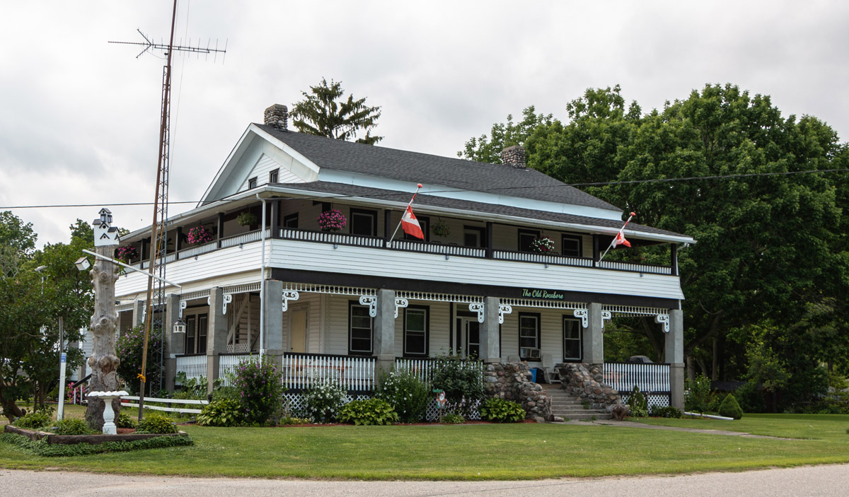
1930s
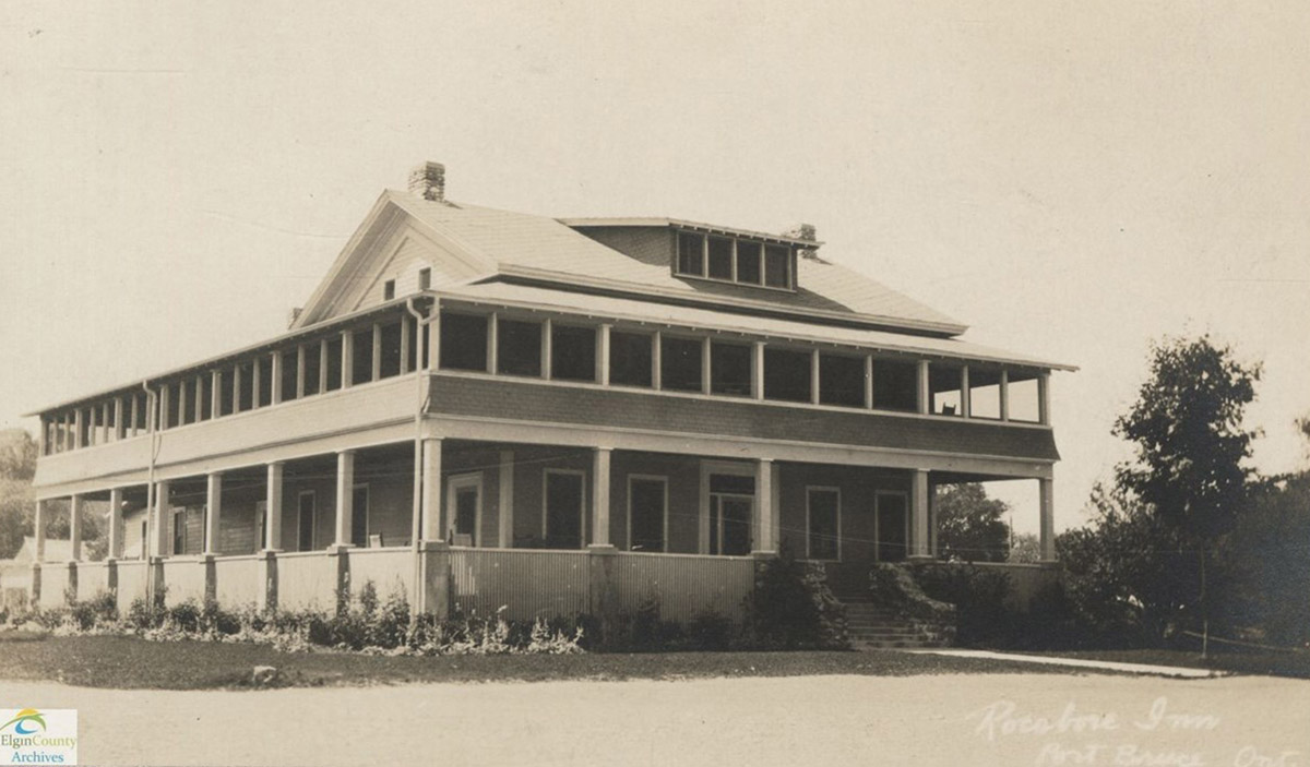
The Rocabore Inn is pictured here in the 1930s. The only hotel for many years in Port Bruce, it was built in 1855 by Amasa Lewis, a grain merchant and land owner who lived nearby. In 1882, a dance hall was added to the building and space was provided in the basement for both a shooting gallery and a bowling alley. In 1924, it was moved back from the river, raised several feet, and renamed. Its new name, the Rocabore, was from a mythical animal with a long and a short leg on either side, the better to scale the area’s steep hillsides. Its current address is 3237 Water Street.
* * *
Tourists were now arriving at the inn by car, and throughout the Roaring Twenties the Rocabore Inn attracted legions of guests. In 1926, a dinner and dance was offered every Wednesday evening starting in mid-July. A full-course meal was served from 6:00 to 8:00 PM, followed by three hours of dancing starting at 9:00 PM.2 "Miss F.K. White, the hostess, left nothing undone to make the evening a splendid success," gushed The Aylmer Express on July 22nd 1926.3 Unfortunately, insufficient attendance at these dinners-and-dances later in the summer forced them to be discontinued for the remainder of the year.4
The Rocabore Inn closed for a couple of seasons during the mid-1930s when worldwide economic depression took its toll on the tourist business, but reopened in 1937 under the proprietorship of Mr and Mrs. Jerry Drynan. Described as "one of the most picturesque, most modern, and best-equipped summer hotels on the north shore of Lake Erie," the old inn once more welcomed guests through its doors for $8.00 per week and up.5 By 1943, the inn had changed hands once again. R.S. Sheppard, who owned a coffee shop in nearby Aylmer, purchased the Rocabore and had it thoroughly renovated and redecorated. For moderate rates, tourists could spend a month, a week, or a day at "one of the finest summer hotels along this shore of Lake Erie."6
The Rocabore Inn wasn’t the only business in Port Bruce to cater to tourists. An enterprise calling itself The King’s Cupboard operated from the 1920s through the 1970s. Located directly across from the Rocabore, it included a dance hall, gas pump, and restaurant.7
Although the King’s Cupboard is no more and the Rocabore Inn now a private residence, tourism remains as lively as ever in Port Bruce, with new restaurants, campgrounds, and cottages welcoming visitors to this charming lakeside resort community each year.
12. The *Uncle Tom*
1890
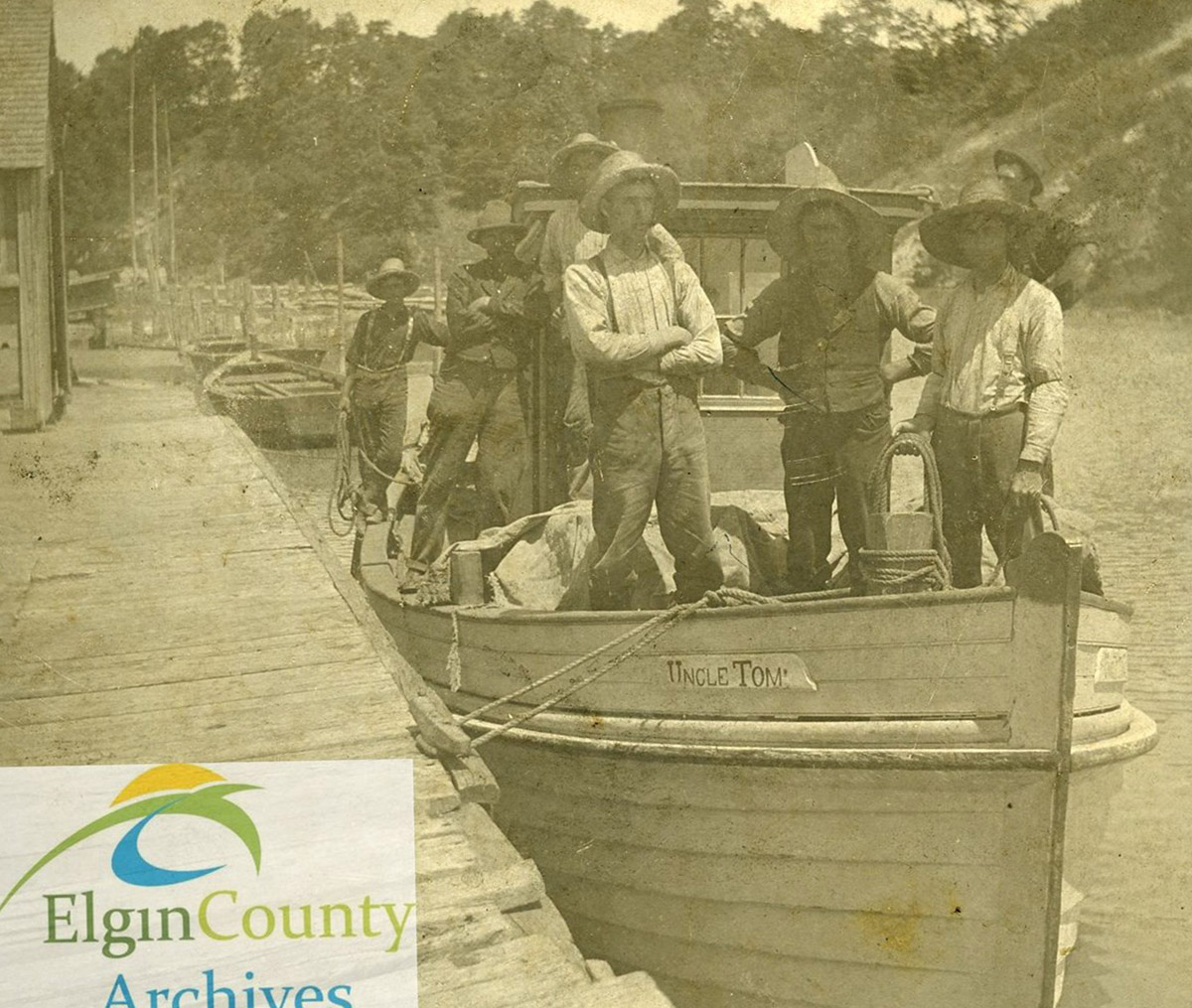
The Uncle Tom was a steam-powered fishing tug owned by the Young Brothers, pictured here circa 1890. It was one of about 15 tugs that fished out of Port Bruce in the early 1900s. In those days, whitefish, herring and blue pickerel were the predominant catch. Most were packed in boxes of 100 pounds each and taken by wagon to Aylmer where they were put on the train for Chicago, Detroit, or New York.
* * *
Among the fifteen or so fishing tugs that worked out of Port Bruce at the turn of the twentieth century was the Uncle Tom. Built by Young & Son of Port Bruce in 1893, the Uncle Tom was an eight-tonne tug powered by a 3.5 horsepower steam engine supplied by noted engine-maker John Doty of Goderich. The boat was forty-seven feet in length, and had a beam of ten feet, eight inches. As of 1901, the Uncle Tom was owned by Levi Young of Port Bruce, but was eventually sold to William Goodhow and Junior Moore, of Port Stanley who operated it into 1907. The Uncle Tom chugged away for another six years before being scrapped in 1913.1
By the mid-twentieth century, steam-powered vessels were giving way to those fuelled by diesel or gasoline, and by the twenty-first century the commercial fishing industry on Lake Erie had declined precipitously. Today, it is but a shadow of what Frank Smale, Wilmont Reid, Jim Burwell, Irvin Smale, and other fishermen knew when they posed on the deck of the Uncle Tom in the 1890s.2
13. The Port Bruce Pier
Aylmer-Malahide Museum & Archives 2011-016-0001
1940s
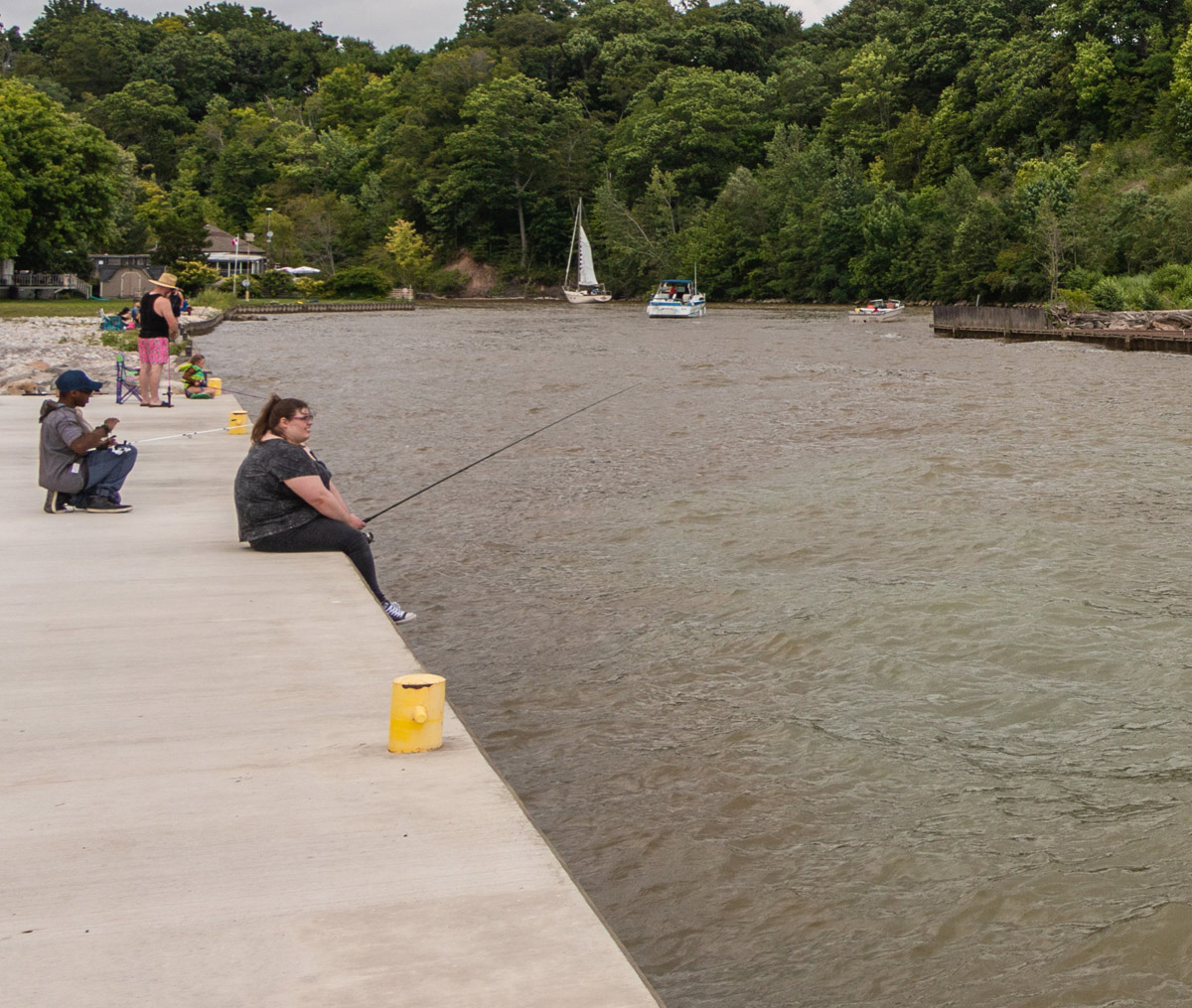
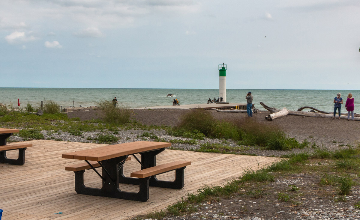
Visitors making their way along the Port Bruce pier enjoy ample space from which to cast a fishing line, tie up a boat, or just lounge while watching the seagulls take off and land. It is an idyllic spot to spend an afternoon – a far cry from the hustle and bustle of commercial activity that characterized the area around the wharf for more than half a century.
* * *
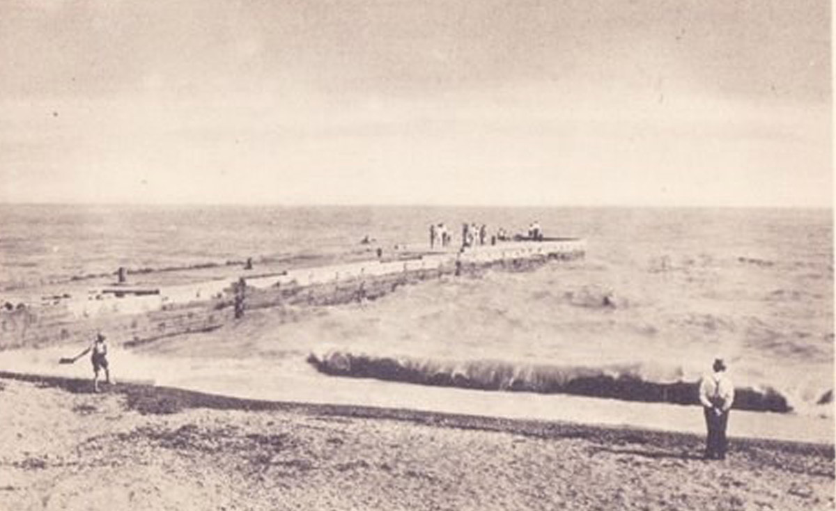
By 1880, competition from the railways had undermined the viability of Port Bruce’s shipping-based economy. Timber and grain was sent out via railway at Aylmer, and the warehouses along the pier at Port Bruce were dismantled. By the turn of the twentieth century, Port Bruce’s economy was centred on commercial fishing. Even so, the fishing industry was dependent on the railway to get its product to markets farther afield, particularly in the United States of America.
As with other parts of the province once dependent on commercial shipping, Port Bruce shifted its focus throughout the twentieth century to recreational boating and the tourism industry that sustained it. The pier remained vitally important, and the federal government constructed another one hundred feet on the east pier over the late summer of 1932. Despite improvements, the structure could be vulnerable to Lake Erie’s waves, which in May of 1943 tore through portions of both the east and west piers causing considerable damage to both. "It would look as if repairs to the two Port Bruce piers this summer will be necessary if the government is to give protection to the thirty or more cottages constructed on beach property," warned The Aylmer Express on May 20th 1943 – a testament to the significance tourism had on the local economy by mid-century.2
A new pier was constructed at Port Bruce in 1949, and in 1955 a 19.8-foot high lighthouse replaced an older structure dating to 1876.3 A storm in 1971 damaged the Port Bruce light, and it was replaced with an automatic light to guide vessels in and out of the community’s storied harbour.
14. Port Bruce Beach
1910
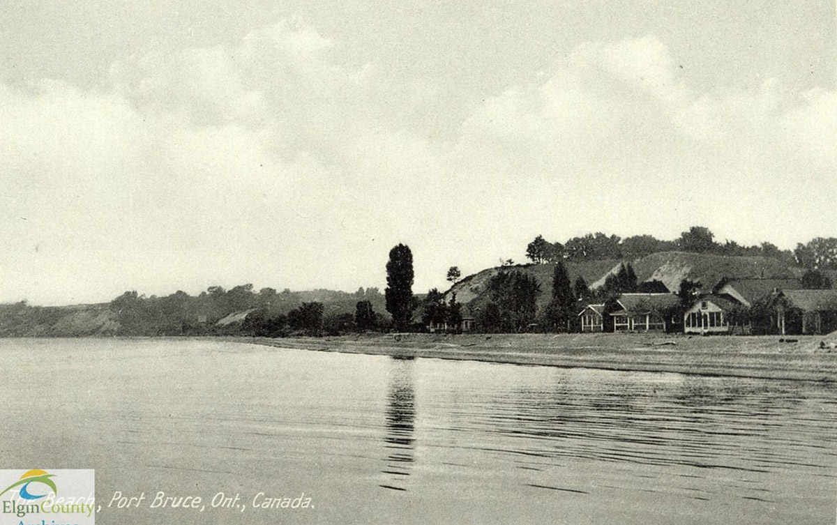
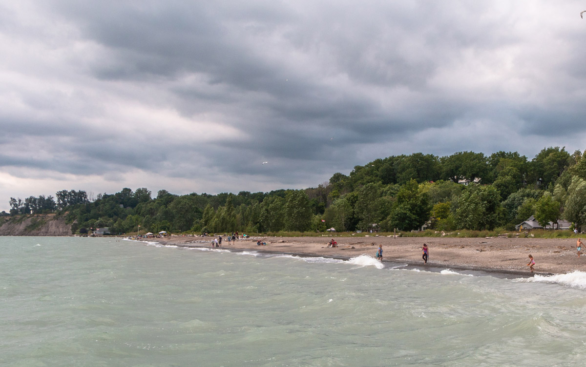
Cycling through Port Bruce reveals many amenities built to cater to the growing tourist trade from the 1920s onward. Many of these tourists, particularly those coming to Port Bruce for a week or longer, stayed in the Rocabore Inn or in one of the nearby housekeeping cottages. Others came for the day, and spent a considerable amount of their time at the Port Bruce Beach.
* * *
The beaches in and around Port Bruce have long attracted entrepreneurs eager to capitalize on summer tourism. A Mr. Wilson purchased fifteen acres not far from downtown Port Bruce and named it Ormond Beach in honour of his daughter. Not long thereafter, a roadside operation called The Apple Green Tourist Camp sprang up on the site and offered a range of modern conveniences to attract travellers. These included electricity, hot and cold running water, picnic tables, and a gasoline station. Ormond Beach was sold to a Mr. Ransome in 1945, who in turn sold it to a consortium of Jewish families that renamed it Wingate Lodge.2
By the 1950s, Port Bruce Beach had become a popular roadside picnic spot and fishing area overseen by the Ontario Department of Highways, with the young and young-at-heart flocking to its sandy surface at the height of the summer season. In 1974, after having been transferred to the Department of Lands and Forests, Port Bruce Beach became a day-use provincial park.
Much has changed in Port Bruce over the century and a half since Amasa Lewis and his contemporaries began shipping grain from the harbour, but one thing that hasn’t changed is the powerful influence Lake Erie has had on residents and visitors alike down through the years.
Endnotes
1. The McNichol House
1. "John McNicol," *Our Family History*, last modified 2022 by Danielle Clark, online.
2. Thomas McIlwraithe, *Looking For Old Ontario,* (Toronto: University of Toronto Press, 1998), 103-140.
2. C.P.R. Station, Belmont
1. "Ontario Southland Railway," Wikipedia: The Free Encyclopedia, online.
2. "Canadian Pacific Railway Station in Belmont Ontario [photograph]," ca. 1950. Ken Verrell Collection, R4 S5 Sh3 B7 F1, Elgin County Archives.
3. Lyons General Store
1. R. B. Fleming, *General Stores of Canada: Merchants and Memories*, (Toronto: Lynx Images, 2002).
2. Hugh J. Sims, *Sims’ History of Elgin County, Vol. 1,* (Aylmer: The Aylmer Express Ltd., 1984), 265-267.
4. Main Street, Springfield
1. "Of Local Interest," *The Aylmer Sun*, June 23 1898, 1.
2. Hugh J. Sims, *Sims’ History of Elgin County, Vol. 3,* (Aylmer: The Aylmer Express Ltd., 1988), 53-56.
3. "Main Street, Springfield [photograph], 1925." Wilfrid Smith fonds, 2014-2, Elgin County Archives.
5. Glencolin Bridge
1. Hugh J. Sims, *Sims’ History of Elgin County, Vol. 1,* (Aylmer: The Aylmer Express Ltd., 1984), 215.
2. "Catcher pouch," Wikipedia: The Free Encyclopedia, online.
3. "Warren Truss," Wikipedia: The Free Encyclopedia, online.
4. Ron Brown, *Disappearing Ontario: Images from our vanishing countryside,* (Toronto: Polar Bear Press, 1999), 55-56.
6. Glencolin Cemetery
1. Hugh J. Sims, *Sims’ History of Elgin County, Vol. 1,* (Aylmer: The Aylmer Express Ltd., 1984), 215.
2. Thomas McIlwraithe, *Looking For Old Ontario,* (Toronto: University of Toronto Press, 1998), 223-238.
7. Luton School (S.S. No. 8 Malahide)
1. Ralph Robinson, *Educating Victoria County: A Local History of Public Education,* (Lindsay: Tri-M Publishing, 1987), 172-175.
2. Hugh J. Sims, *Sims’ History of Elgin County, Vol. 1,* (Aylmer: The Aylmer Express Ltd., 1984), 263.
3. A. Guy & M. Cottrell, "School Facilities," *The Canadian Encyclopedia,* last updated March 4 2015, online.
8. Dunboyne Cheese Factory
1. Sims, Hugh J. Sims’ History of Elgin County, Vol. 1. Aylmer: The Aylmer Express Ltd., 1984. Pg. 113.
2. "Dunboyne Cheese Co.," *The Aylmer Express,* February 27 1908, Pg. 2
3. "Additional Locals," The Aylmer Express, January 23 1908, Pg. 2
9. Thayer's Gas Bar
1. Thayer’s Standard Gasoline Station, Aylmer [photograph], ca. 1940. Wilfrid Smith fonds, 2014-2, Elgin County Archives.
2. Hugh J. Sims, *Sims’ History of Elgin County, Vol. 1,* (Aylmer: The Aylmer Express Ltd., 1984), 113.
3. L.C. McFarlane, "Gasoline Stations," *The Canadian Encyclopedia*, last updated March 4 2015, online.
10. Amasa Lewis House
1. Ron Brown, Castles & Kings: Ontario Mansions and the People Who Lived in Them. (Toronto: Polar Bear Press, 2001).
2. Hugh J. Sims, *Sims’ History of Elgin County, Vol. 1,* (Aylmer: The Aylmer Express Ltd., 1984), 82.
3. "Port Bruce Manor," *Elgin County*, online.
11. Rocabore Inn
1. Hugh J. Sims, *Sims’ History of Elgin County, Vol. 1,* (Aylmer: The Aylmer Express Ltd., 1984), 84.
2. "Dinner and Dance at Rocabore Inn" (advertisement), "The Aylmer Express," July 15 1926, 3.
3. No title, *The Aylmer Express,* July 22 1926, 1.
4. "Port Bruce," *The Aylmer Express,* August 26 1926, 2.
5. "Rocabore Inn Now Open At Port Bruce," *The Aylmer Express,* July 1 1937, 1.
6. "Rocabore Inn To Open Soon," *The Aylmer Express,* May 20 1943, 1.
7. "The King’s Cupboard [photograph], ca. 1945," W. Gordon Chalk fonds, 2002-03, Elgin County Archives.
12. The *Uncle Tom*
1. "UNCLE TOM (1893, Fish Tug)," Alpena County George N. Fletcher Public Library/Northeast Michigan Oral History and Historic Photograph Archive.
2. "Uncle Tom, Steam Tug [photograph], ca. 1890s," Elgin County Vertical File Collection, 99-7, Elgin County Archives,
13. The Port Bruce Pier
1. Hugh J. Sims, *Sims’ History of Elgin County, Vol. 1,* (Aylmer: The Aylmer Express Ltd., 1984), 84.
2. "Port Bruce Pier Is Damaged," *The Aylmer Express,* May 20 1943, Pg. 1
3. Wright, Larry and Patricia. Great Lakes Lighthouses Encyclopedia. Erin: Boston Mills Press, 2006. Pg. 147.
14. Port Bruce Beach
1. Southern Ontario Highway Association, "Lake Erie North Shore Trail, Ontario, Canada, 1927 Edition" (1927). SWODA: Windsor & Region Publications. Pgs. 28-29.
2.Hugh J. Sims, *Sims’ History of Elgin County, Vol. 1,* (Aylmer: The Aylmer Express Ltd., 1984), 85-86.
Bibliography
Alpena County George N. Fletcher Public Library/Northeast Michigan Oral History and Historic Photograph Archive. "UNCLE TOM (1893, Fish Tug)." https://www.nemoha.org/2898644/data
Brown, Ron. *Castles & Kings: Ontario Mansions and the People Who Lived in Them.* Toronto: Polar Bear Press, 2001.
Brown, Ron. *Disappearing Ontario: Images from our vanishing countryside.* Toronto: Polar Bear Press, 1999.
Elgin County. "Port Bruce Manor." https://www.progressivebynature.com/node/847
Elgin County Archives. "Canadian Pacific Railway Station in Belmont Ontario [photograph]." ca. 1950. Ken Verrell Collection, R4 S5 Sh3 B7 F1.
Elgin County Archives. "Main Street, Springfield [photograph], 1925." Wilfrid Smith fonds, 2014-2.
Elgin County Archives. "Thayer’s Standard Gasoline Station, Aylmer [photograph], ca. 1940." Wilfrid Smith fonds, 2014-2.
Elgin County Archives. "The King’s Cupboard [photograph], ca. 1945." W. Gordon Chalk fonds, 2002-03.
Elgin County Archives. "Uncle Tom, Steam Tug [photograph], ca. 1890s." Elgin County Vertical File Collection, 99-7.
Fleming, R.B. *General Stores of Canada: Merchants and Memories.* Toronto: Lynx Images, 2002.
Guy, Allan & Cottrell, Michael. "School Facilities," *The Canadian Encyclopedia.* Last updated March 4 2015. https://www.thecanadianencyclopedia.ca/en/article/school-facilities
McIlwraithe, Thomas. *Looking For Old Ontario.* Toronto: University of Toronto Press, 1998.
McFarlane, L.C. "Gasoline Stations," *The Canadian Encyclopedia.* Last updated March 4 2015. https://www.thecanadianencyclopedia.ca/en/article/gasoline-stations
*Our Family History.* "John McNicol." Last modified 2022 by Danielle Clark, http://clark-debisschop.co.uk/tng/getperson.php?personID=I16541&tree=Clark.
Robinson, Ralph. *Educating Victoria County: A Local History of Public Education.* Lindsay: Tri-M Publishing, 1987.
Sims, Hugh J. *Sims’ History of Elgin County, Vol. 1.* Aylmer: The Aylmer Express Ltd., 1984.
Sims, Hugh J. *Sims’ History of Elgin County, Vol. 2.* Aylmer: The Aylmer Express Ltd., 1988.
Sims, Hugh J. *Sims’ History of Elgin County, Vol. 3.* Aylmer: The Aylmer Express Ltd., 1988.
Southern Ontario Highway Association. "Lake Erie North Shore Trail, Ontario, Canada, 1927 Edition." (1927). SWODA: Windsor & Region Publications. https://scholar.uwindsor.ca/cgi/viewcontent.cgi?article=1049&context=swoda-windsor-region
Wikipedia. "Catcher pouch." https://en.wikipedia.org/wiki/Catcher_pouch
Wikipedia. "Ontario Southland Railway." https://en.wikipedia.org/wiki/Ontario_Southland_Railway
Wikipedia. "Warren Truss." https://en.wikipedia.org/wiki/Warren_truss
Wright, N.T. *Surprised By Hope.* New York: HarperCollins Publishers, 2008.
Wright, Larry & Wright, Patricia. *Great Lakes Lighthouses Encyclopedia.* Erin: Boston Mills Press, 2006.
**Newspaper Articles**
"Additional Locals," *The Aylmer Express.* January 23 1908, 2.
"Dinner and Dance at Rocabore Inn" (advertisement), The Aylmer Express, July 15 1926, Pg. 3
"Dunboyne Cheese Co.," *The Aylmer Express,* February 27 1908, 2.
"Of Local Interest." *The Aylmer Sun.* June 23 1898.
"Port Bruce," *The Aylmer Express,* August 26 1926, 2.
"Port Bruce Pier Is Damaged," *The Aylmer Express,* May 20 1943, 1.
No title, *The Aylmer Express,* July 22 1926.
"Rocabore Inn Now Open At Port Bruce," *The Aylmer Express,* July 1 1937, 1.
"Rocabore Inn To Open Soon," *The Aylmer Express,* May 20 1943, 1.