Walking Tour
End of Steel to Mile 0
The Story of Dawson Creek
By Andrew Farris
South Peace Historical Society 2021.026.173
Welcome to the "End of Steel to Mile 0" walking tour of Dawson Creek! As you explore this historic town, you'll uncover the fascinating story of its rapid growth from a railway terminus to Mile 0 of the Alaska Highway. This tour highlights key locations and events, showcasing Dawson Creek's early days, wartime boom, and post-war development. Look for accompanying plaques along the way, providing further insights into the rich history of this unique community.


The City of Dawson Creek acknowledges that we are privileged to live and work on Treaty 8 territory and the traditional home of the Cree, Dane-Zaa, Saulteau, Sikanni and Slavey First Nations. We value the Métis Peoples that live and gather here.

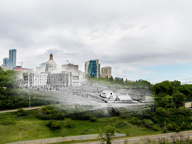
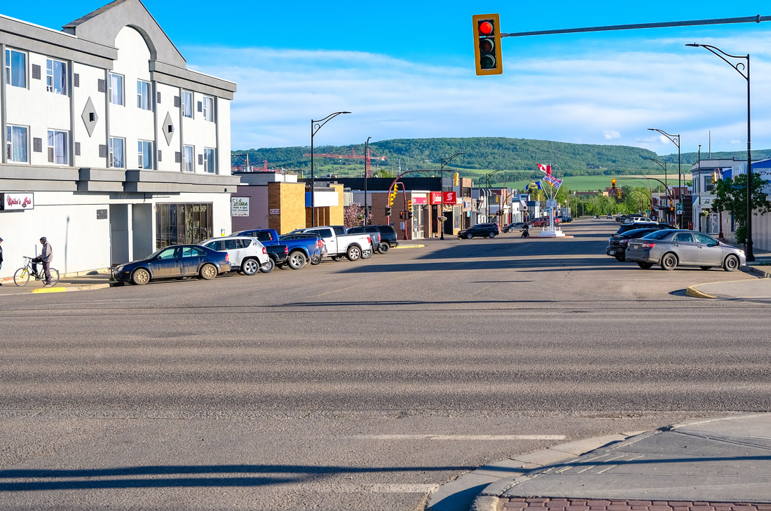
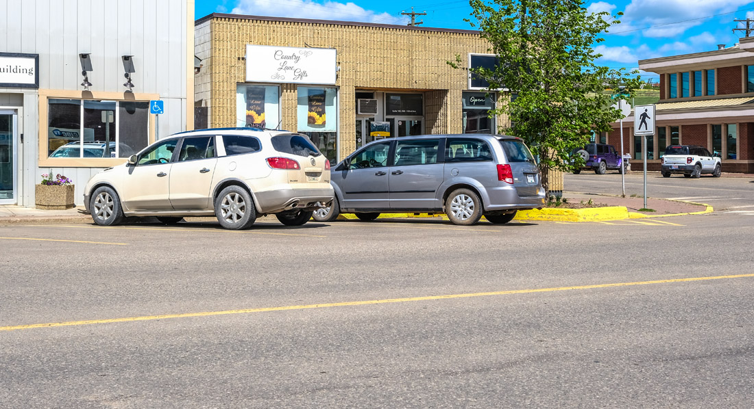
1. Peace Country
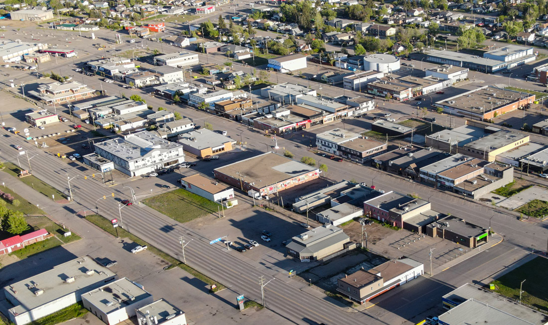
South Peace Historical Society 2000.061.010
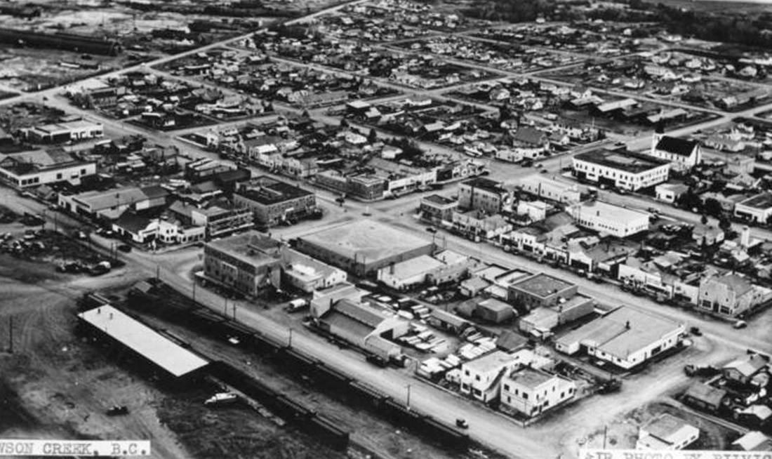
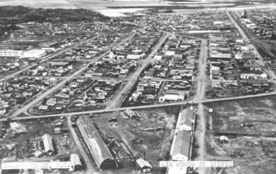
1949
We begin our tour with this aerial view of Dawson Creek taken in 1949, alongside another taken from the same angle today.
Dawson Creek was founded in 1931, which is fairly late as far as Canadian towns go. Yet it grew and matured very quickly. This historic photo was taken less than 20 years after its founding, and we can already see that Dawson Creek's downtown had filled out much of the space it occupies today. It has continued to grow and develop since that time, though most of that development has spread out to the suburbs.
* * *
Dawson Creek is at the extreme northwestern corner of the vast prairies that extend across much of Alberta, Saskatchewan, and Manitoba. It is defined by the mighty Peace River, which carves a wide, fertile valley across the region on its journey to the Arctic Ocean. Located in the subarctic boreal zone, the climate can be challenging, with long, cold winters and short, warm summers. There is relatively little rain, which promotes the growth of hardy grasses and forests of poplar and spruce.
This region has been inhabited by Indigenous peoples since time immemorial. These include the Dane-zaa, Beaver, and the Cree. According to Dane-zaa oral history the name of the mighty river that defines the region comes from a great peace treaty once agreed between the Cree and Beaver peoples at a place near the confluence of the Peace and Slave Rivers.
The Beaver and Cree lived semi-nomadic lifestyles that were perfectly suited to the challenging sub-arctic conditions. They hunted game, fished, and gathered plants, and moved seasonally to follow resources. They lived in shelters like tipis and lodges and crafted sophisticated tolls from the materials ready to hand. Their spiritual practices honoured animals and the environment, and knowledge was passed down from generation to generation through oral tradition. The Peace River was for them a key travel and trade route.
Starting in the 1700s, European fur traders started to bring changes, and a Metis community came into being. In the late 1800s and early 1900s there was an influx of white settlers, and the Cree and Dane-zaa were dispossessed of their land and confined to reservations. Nevertheless, the Dane-zaa and Cree have continued to preserve their cultural heritage and continue to advocate for the return and protection of their traditional lands.1
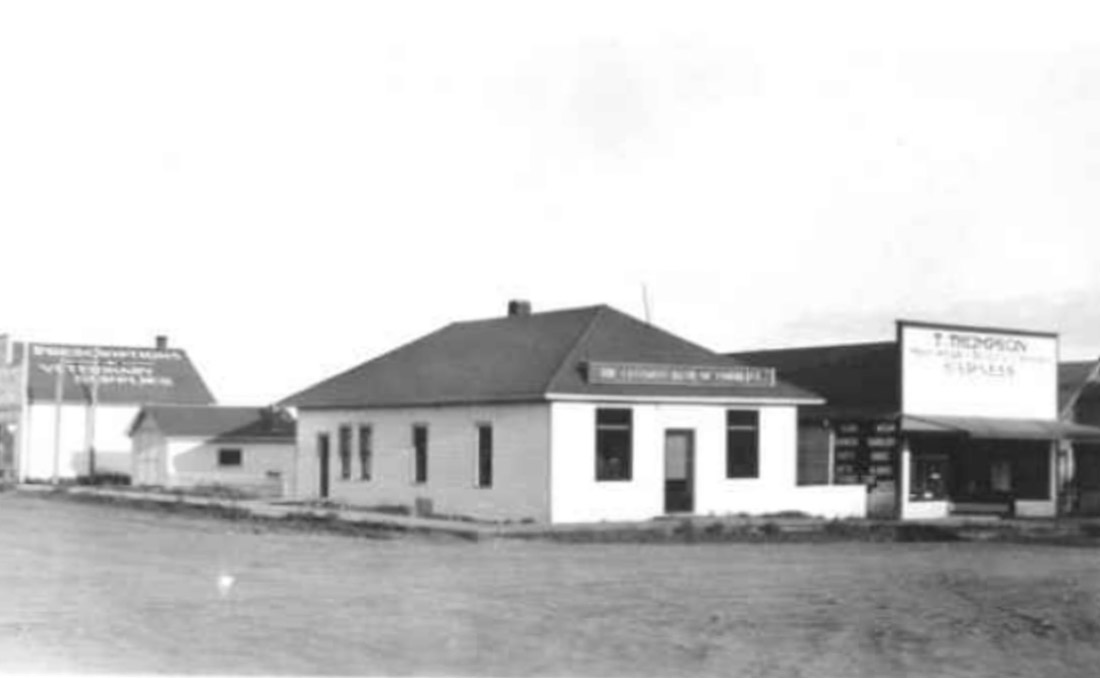
2. The Northern Alberta Railway
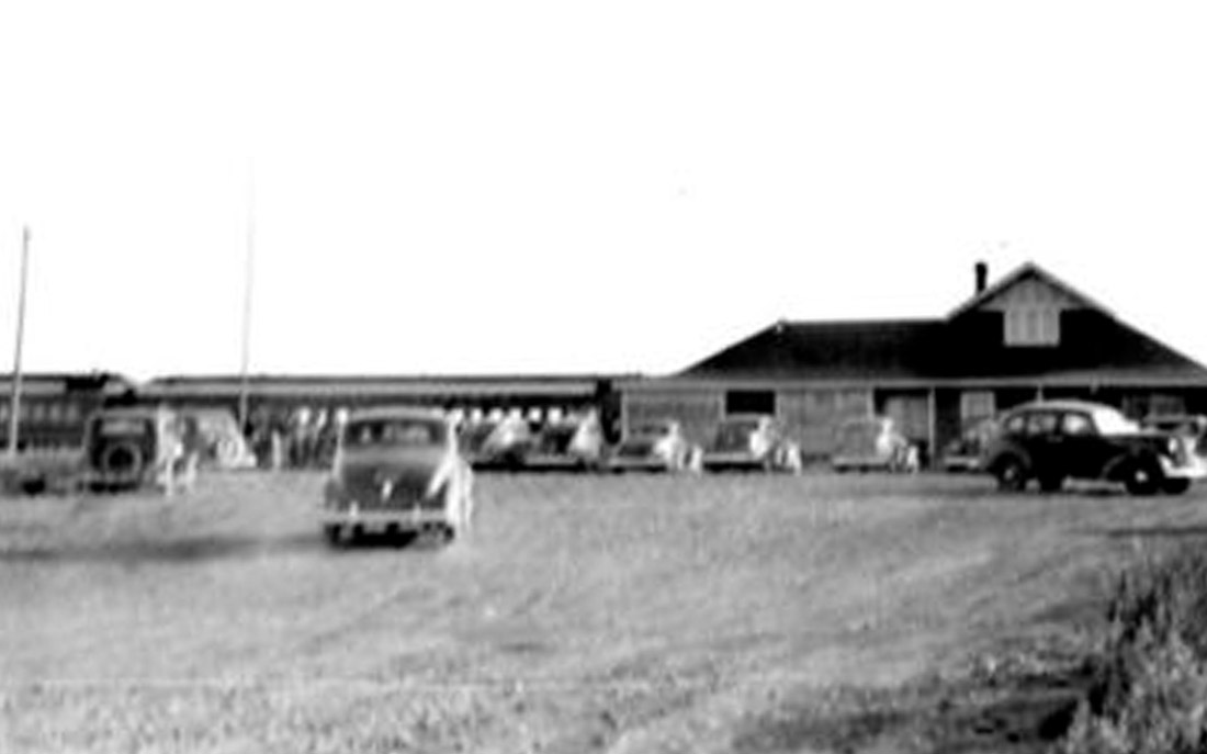
South Peace Historical Society 2000.035.009
1940
For the first couple decades of the town's history, this railway station was how almost everybody and everything arrived in Dawson Creek. It was the terminus station of the Northern Alberta Railway (N.A.R.). As the end of the railway it was called End of Steel. It was actually the decision to make End of Steel at this spot that led to the establishment of Dawson Creek here, rather than the other way around.
An important aspect of Dawson Creek's history is that the railway came from Edmonton, Alberta, rather than the population centres of southern British Columbia. This meant that Dawson Creek's early cultural and economic development were heavily oriented towards neighbouring Alberta.
* * *
Dawson Creek's being in British Columbia rather than Alberta is a bit of a historical curiosity. In 1863 British colonial administrators were drawing up the border between what would become the two provinces, and they picked the Rocky Mountains as the demarcation. As a result the southern Alberta-BC border is very jagged, understandably to conform with the topography. However at that time the cartographers in the Colonial Office in London only had good maps up to the 53rd Parallel. North of that was pretty much a blank on the map, and they didn't really know where the Rockies were. So they just drew a straight line north from the 53rd parallel all the way up to the Arctic Circle at the 60th parallel, and called it a day. Everything west of that is today British Columbia.1
This put the enormous and fertile territory of the Peace Country under the administration of a province that was cut off from it by the Rocky Mountains. No road or rail links to the rest of BC would be completed until after the Second World War. Alberta, on the other hand, was only 15 kilometres east of Dawson Creek and there weren't any mountains in the way.
That meant that everyone who came to Dawson Creek got here via Alberta. Many of those who came to farm the Peace Country or settle in the town were themselves from Alberta. Unsurprisingly, the economy developed along much the same lines as Alberta's own Peace Country. Most cultural influences came from Alberta too: until the late 1940s the only radio station in Dawson Creek was broadcasting from Grand Prairie.
Like so many lines drawn on maps in London's Colonial Office, this decision led to a rather strange state of affairs. A region that had so many similarities to the province right next door was governed from Victoria, about 1,000 km to the southwest. The Peace Country's MLA could only take his seat in the provincial legislature by flying there or taking an extremely circuitous route through Alberta.
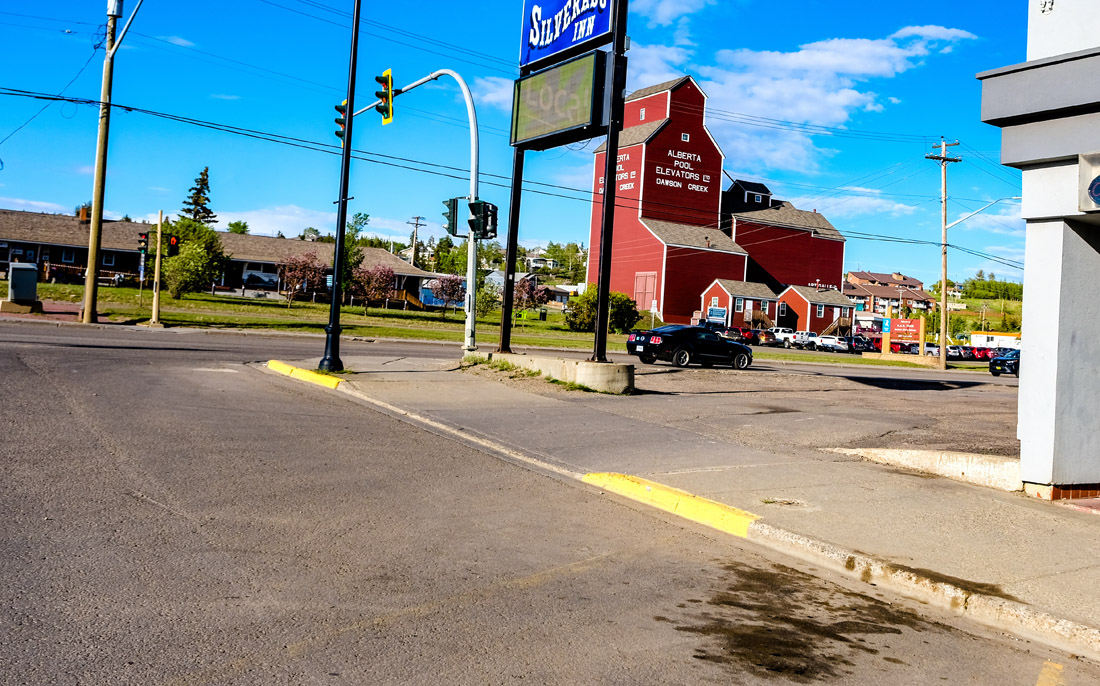
3. Fertile Soils
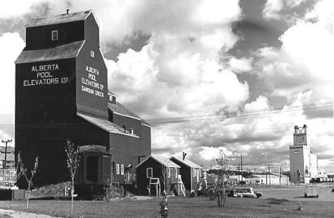
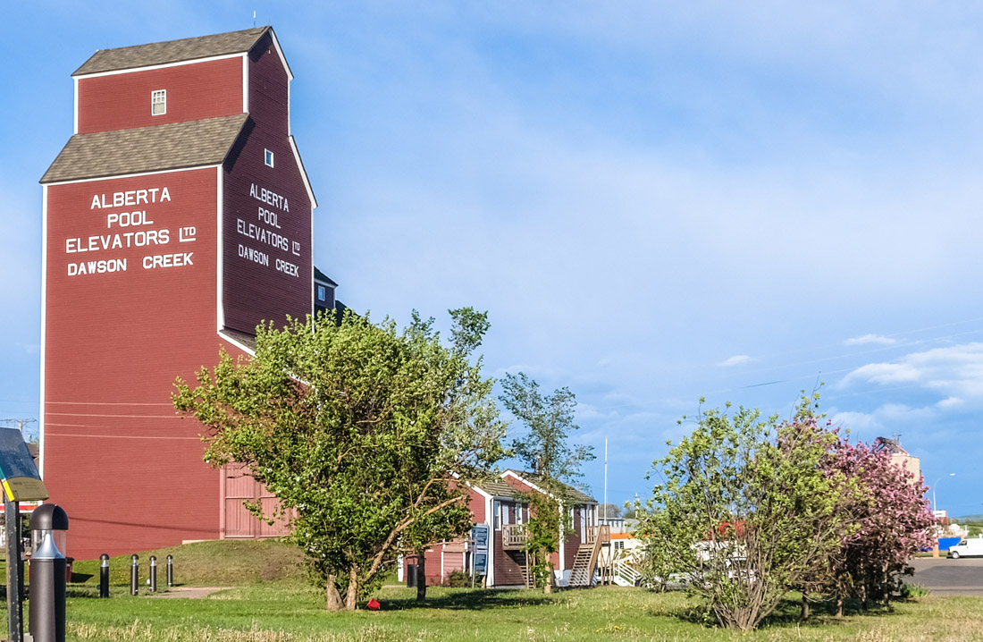
South Peace Historical Society 2000.051.063
1985
This 1985 photo shows Northern Alberta Railway (N.A.R.) Park with the Dawson Creek Art Gallery housed in the historic grain elevator. Unlike many agricultural towns on Canada's prairies, Dawson Creek has preserved one of the grain elevators that once dominated the town's skyline. This grain elevator is a fundamental part of Dawson Creek's heritage, and indicates the main driving force behind the early European settlement of this region and Dawson Creek's main economic engine in its early years.
* * *
After the First World War that began to change. The Canadian government encouraged veterans to settle here and begin farming. Many took up the offer and found success growing wheat as well as oats that supported cattle ranching.
The biggest change came when the Northern Alberta Railway opened up access to this region, reaching the new-found community of Dawson Creek in 1931 and providing the Peace Country's first year-round road or rail link with the outside world. Five huge grain elevators like the one you see here were constructed to house the wheat as it waited to be exported by rail.
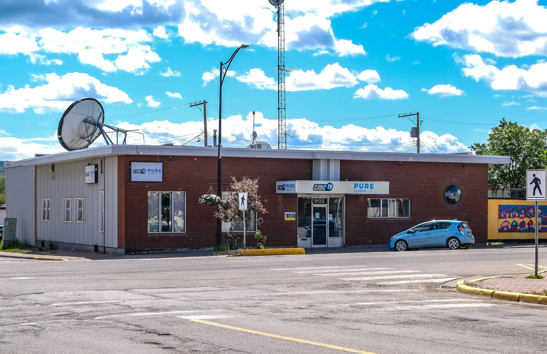
This coincided with the Great Depression and a historically severe drought across much of the prairies. The Peace Country fared somewhat better and so during the 'dirty 30s' many desperate farmers from Alberta and Saskatchewan relocated to the Peace Country to try their luck.
Agriculture in the Peace Country underwent a massive boom in the 1950s as farmers diversified and increasingly cultivated canola, barley, flax, peas, and honey.
Though the grain elevators are now gone—with the exception of the one converted into an art gallery—agriculture continues to lead this region's economy. There's about 11.5 million acres of farmland in the region, over a quarter of all the farmland in BC. That land supports some 1,500 farms that produce, among other things, over 90% of the province's grain and 95% of its canola.2
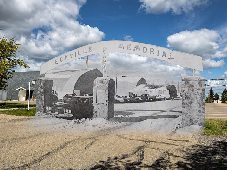
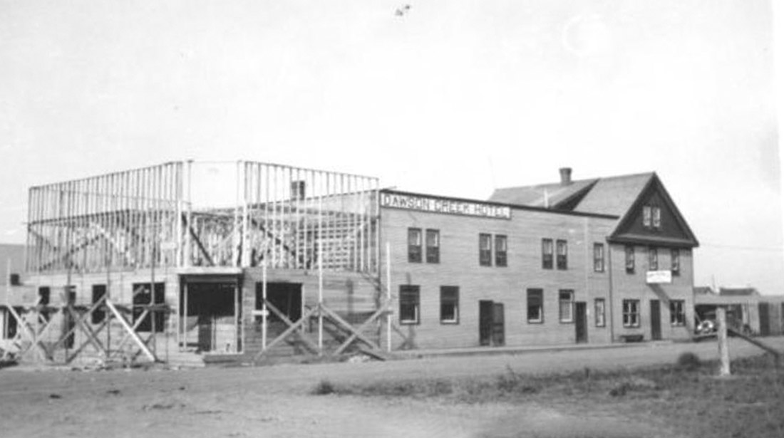
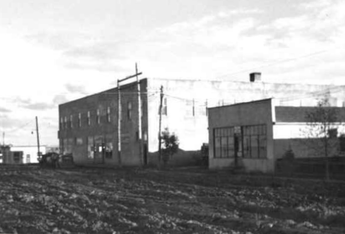
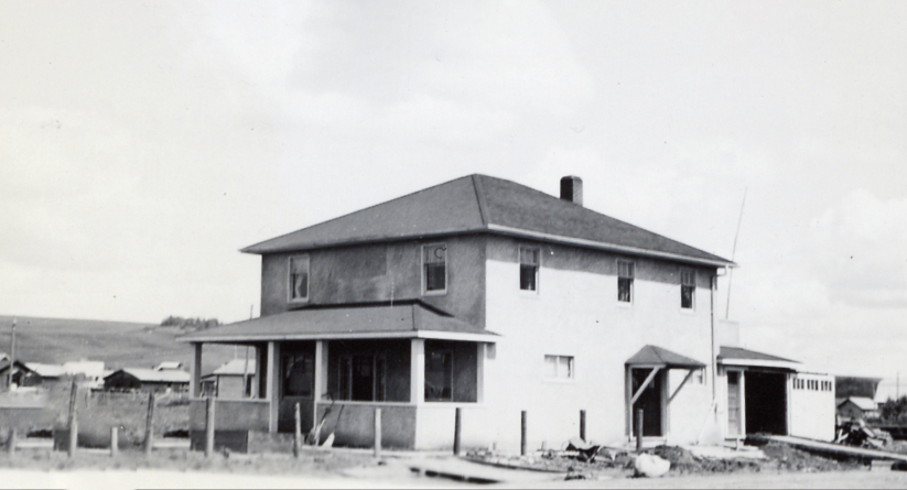
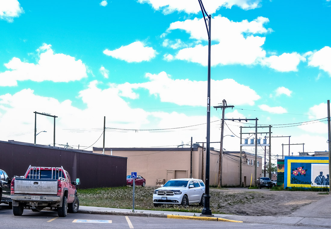
4. The Dawson Hotel
South Peace Historical Society 2000.061.029
1936
In this view looking across Alaska Avenue, opposite the N.A.R. Station, we see the Dawson Hotel going up. "The Dawson" became a community landmark in those early years, and was one of several hotels that anchored the new community of Dawson Creek.
When the town was established many of its first inhabitants came from a small community now remembered as Old Dawson. In 1931 they had made the bold decision to pack up their whole village—buildings and all—and move to Dawson Creek. These people formed the nucleus of the new town.
* * *
Whichever community was picked as the terminus was sure to become the biggest town in the region. However, the railway had difficulty getting any local farmers in those communities to sell them an appropriate plot of land for a townsite. Getting frustrated, the N.A.R. decided to talk to Duncan 'Dunc' McKellar, who owned most of the land around Dawson Creek. Dorthea Calverley, a historian and chronicler of Dawson Creek's early history, records what happened next:
"One day in early 1930 a railway employee sought out McKellar to drive him over the area. At the end of their tour of inspection he told Dunc, 'You are looking at the future site of the town of Dawson Creek'. Dunc’s land was flat, and large enough for the railway’s purpose. They agreed on a reasonable price.
"Construction began at once on the high wooden trestle across the [Dawson Creek], the subdivision of town lots, the location of a huge water reservoir on the west side of town, the railway station [now a museum], freight sheds, shops and the 'wye' [railway turntable]. Five [grain] elevators were rushed to completion."1
The railway's decision sent reverberations around the region and sealed the fate of the other communities.
"Not only did Rolla and Pouce Coupe see their commercial dreams collapse, but so did the bustling little centre known as Bullenville, a short distance southwest of Dawson Creek. The village was locally known as 'Donation Creek' or 'Moonshine Centre.' The good citizens of that informal village [Bullenville] accepted their lot philosophically, and moved lock, stock and barrel to the new Dawson Creek. Thereafter, the deserted location became known as 'Old Dawson.'"2
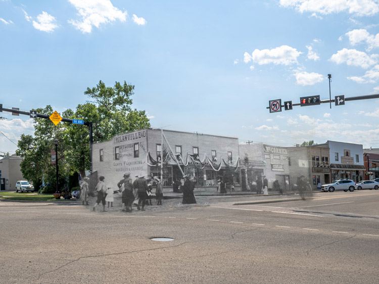
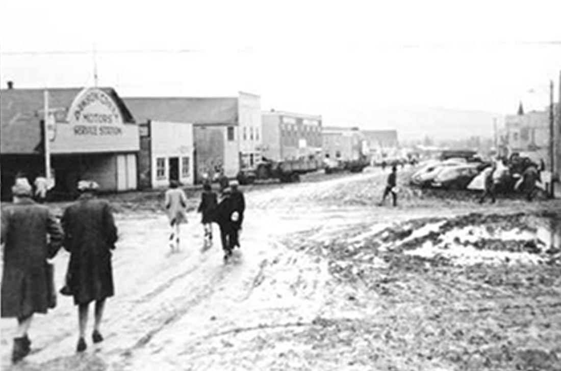
5. 10th Street in the 40s
South Peace Historical Society 2000.080.009
1942-3
This photo, taken in 1942 or 43 shows a busy, built-up, and muddy 10th Street. A whole range of businesses have sprung up, and the many new-looking cars and trucks and fashionably dressed men and women hint at the success of the rapidly growing town. As the N.A.R.'s End of Steel, Dawson Creek prospered as the service hub for farmers across the region.
* * *
Dawson Creek continued its slow but steady growth through the rest of the 1930s, a feat more remarkable than it may first appear. These were the Dirty 30s, when the worldwide Great Depression coincided with a brutal years-long drought on Canada's prairies. Most farming towns in Alberta and Saskatchewan stagnated or shrank in population over this decade as 'dust bowl' conditions literally blew away the fertile soils upon which their prosperity depended.
The Peace Country Block, the triangle of arable prairie in northeastern BC, had only just been opened up for settlement, and it wasn't as badly affected by this drought. Word spread, and many farmers who had given up on their plots to the east resettled in the Peace Country in search of better fortunes.
Even though Dawson Creek weathered the 1930s relatively well, and could look forward to better years to come, it's unlikely anyone foresaw the colossal changes that would come to Dawson Creek in the aftermath of the Japanese attack on Pearl Harbor. Within a couple months Dawson Creek would become Mile 0 of a titanic Allied effort to protect Alaska by connecting it to the rest of North America.
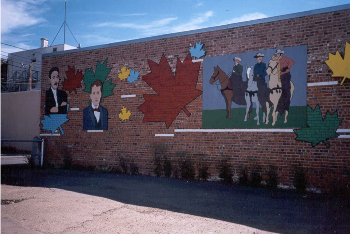
6. 1940s Street Scene Mural
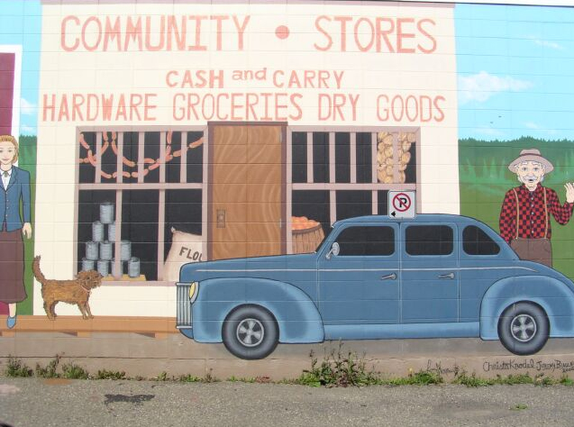
As you walk down 10th Street, take a peek into the alley on your right. On the wall on your right side you'll find a mural showing a street scene in Dawson Creek at the outset of the building of the Alaska Highway in early 1942. You get a sense of a town on the cusp of a great transformation.
On the one hand there are signs of Dawson Creek's roots as a quiet frontier town. In front of the church a rather exasperated-looking trader makes a futile effort to get his stubborn pack horse to obey. A cheerful First Nations' couple stand outside the small square-fronted offices of the D.W. Faust Contractor & Builder. The woman's walking stick would seem to indicate they've hiked into Dawson Creek, perhaps to do some shopping and to get the latest news of the outside world. A rather rustic looking farmer beckons to the viewer, perhaps to come in and visit the Cash and Carry general store.
There are also signs of modernity. A huge sleek automobile looks distinctly out of place on the unpaved street. The First Nations man is holding a copy of the Peace River Block News with a headline blaring US & CANADA JOIN FORCES TO BUILD ALASKA HIGHWAY. Nearby a bewildered looking US soldier sits on the sidewalk with his rucksack, perhaps wondering how he ended up in remote northern Canada. He looks every bit the 'Doughboy', the common nickname for American soldiers in those days.
* * *
Demuynck was born in 1930 to parents who had recently immigrated from Germany. They homesteaded on the prairie outside Edmonton and she grew up during the brutal Dust Bowl and Depression of the 1930s. She soon discovered she had a talent for art and attended the University of Alberta and the Banff School of Fine Arts.
She later moved with her husband and son to Dawson Creek and began teaching art at Northern Lights College, while serving as president of the South Peace Art Society and the Peace Watercolour Society.
A prolific artist featured in galleries across Canada, in 1999 the Dawson Creek Art Gallery staged an exhibition of her work entitled "A Life's Journey." The exhibit showed how Demuynck "experimented with nearly every form of conventional artistic expression over the years -- paintings, watercolours, sculpture, photography, printmaking,"
An article in the Dawson Creek Daily News explained how, around the time she painted this mural, she was "focusing on an art form she calls 'creative painting' where realistic images are played with, and certain details are removed, creating a more stylized atmosphere."
"'It can be an abstract form or it can be a play on realism,' she said. 'I think it's more exciting because realism is more obvious. I think it gives your work more sparkle.'"1
Demuynck retired some years after, and passed away in 2022 at the age of 92. Her decades of teaching and painting in Dawson Creek left an indelible mark on this community's art scene and her "many creations brought joy to very many people."2
7. The Co-op Store
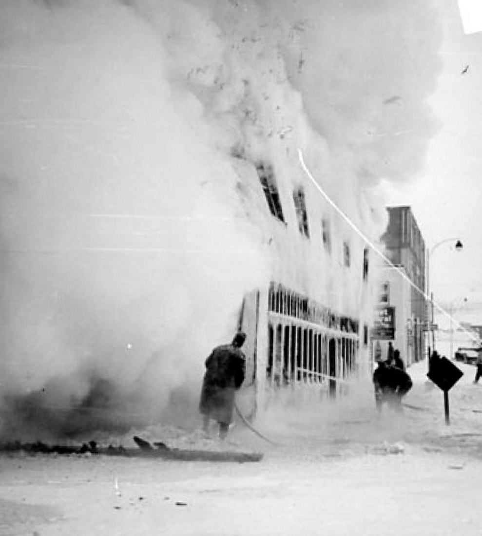
South Peace Historical Society 2022.002.101
1948
Here we see firefighters battling a fire that has engulfed the Dawson Creek Co-op Union. The Co-op store is one of the town's oldest businesses, having been founded at the old Dawson Creek townsite in 1921 and then moved to this spot in the new Dawson Creek a decade later. While the building didn't survive this fire, the Co-op did. Rather than rebuild here it was moved to a new location on the other side of 8th Street, near the Mile 0 roundabout. It remains there to this day.
* * *
Co-ops allowed farmers to pool their resources for a rainy (or rainless) day, speak with one voice to negotiate with distributors and politicians, and become a focus for communal collective action. By working together through Co-ops, small farmers could ensure nobody in the community got left behind.
Dawson Creek's farmers formed their co-op in 1921 at the old townsite and held their first meeting at Dawson Creek's one room schoolhouse. One of their first initiatives was to establish a Co-op Store. Since Dawson Creek was so remote (the railway wouldn't arrive for almost another decade), private businesses charged sky-high prices to import all the goods people needed to survive. With a Co-op Store that everyone could invest in, they could buy goods cheaply in bulk, sell them at a reasonable price, and redistribute any profits to the community.1
In their first share selling campaign in 1921 they raised $875 (around $15,000 today), enough to rent space for the store and stock it with inventory. E.L. Hauger, a Norwegian shopkeeper who had run a co-op store in the American Midwest, was hired as manager. He was the right man for the job. He would stay in that position until 1944, shepherding the store through a period of tumultuous change.
Within a year the co-op was turning a profit and paying out dividends to its investors. Hauger was "too good a storekeeper to be satisfied with the inadequate store building and stock he had to work with," and raised more funds to build a new and expanded store, much of it out of his own pocket.2
In 1931 the railway came to Dawson Creek, ending at the new townsite some 2.5 kilometres away from the old townsite. The Co-op had to move. Rather than disassemble the store and reassemble it by the train station, the entire building was lifted bodily onto log rollers and dragged by horses. The move took two and a half weeks, at an average speed of 6 metres an hour. The Co-op Store remained open the whole time.3
Established at this prime lot on the corner of 10th Street and 102nd Avenue, it became a lynchpin of the community through the 1930s. Business boomed when the US Army arrived to build the Alaska Highway in 1942, but when a nearby truck filled with TNT accidentally exploded on February 13, 1943, it seemed as if the store--along with much of the town--would burn.
There was no water supply or firefighting equipment on hand to fight the rapidly growing conflagration; the only available water had to be bucketed from ditches. The US Army Engineers leapt into action. Many of them were black soldiers whose racist ban on entering the town was relaxed in the emergency. Through their heroic efforts the Co-op Store was saved, along with its inventory estimated at $1.5 million in 2026 dollars.4
During another fire in 1948, the one you see in the historic photo above, the store's luck ran out. By that time however the Co-op was on firm footing. Annual revenues had grown to over $7.5 million per year in today's money, and they were able to rebuild at the new location.
Ever since the Co-op has prospered and continued to grow. They also now operate a series of gas stations across the Peace Country.5
8. People of the Community Mural
If you cross back over the street and walk around the former Coop building, on the west wall facing the parking lot you'll find the second mural in Dawson Creek's Community Mural project. Called People of the Community, it was designed in 2001 by Calvin Kruk and painted by local art students. You may recognize Kruk's name because later on in this tour we will visit the Centre for the Performing Arts that was later named for him. He became mayor of Dawson Creek in 2005 and was a strong advocate for community arts before his untimely passing in 2008.
* * *
There are a number of early pioneer homesteaders, like John Gobin and his son Forrest, who homesteaded near Rolla in 1912. On horseback we see the three Johnson brothers, Earl, Allan (Spike) and Efner who came from North Dakota and settled in the Carpio District.
There are also well respected community builders, like Jack and Olive Flynn, who arrived in the Peace in 1917, and Bill and Mary Mollard, seen here with their children Wilma and Robert who helped develop the Clayhurst-Cherry Point Area.
Mr. and Mrs. Mah Show came to Canada from southern China in the 1930s and settled in Dawson Creek, where they purchased Harper's Store and turned it into the New Palace Hotel, helping establish the town's Chinese community.
Finally we see the US Army Engineers, both white and black, who overran Dawson Creek during the building of the Alaska Highway, and the RCMP, who took over in Dawson Creek from the BC Provincial Police in 1950.1
9. Explosion Block

South Peace Historical Society 2000.050.232
February 1943
This jarring photo was taken looking back towards downtown Dawson Creek. It shows a scene of utter devastation, the aftermath of the greatest disaster in Dawson Creek's history. On February 13, 1943, a fire started by a dropped lamp in a barn ran out of control and ignited a nearby truck of TNT. The resulting explosion destroyed most of the downtown, killing 5 people and causing an estimated $350,000 in damages, about $6.2 million today.
* * *
She watched as townsfolk and nearby soldiers went to work dousing the blaze in the barn, which was stuffed to the brim with telephone lines, tools, and vehicle parts. Just across the street a standing-room-only train had arrived and disgorged its passengers into the street, who gathered into a gigantic crowd to watch. It was then that the firefighters discovered to their dismay that someone had parked a truck of TNT in the barn.
Watching from a distance, Calverley recalled:
"Suddenly a DIFFERENT flame shot out from the eastern side. It was a swirling cylinder of lurid, coloured flames and indescribable fumes and smoke that ascended at an angle.
Next she remembered seeing:
"the sudden falling down of those nearest the building, followed by a concentric falling of those farther and farther away. Before the sound or blast reached the spectators a block away, they had time to wonder what ailed everybody that they were lying down in circles one after another. Then the blast hit them and over they would go like a bowling pin.
"The burning building and its contents — completely red-hot — went hundreds of feet in the air. Where the brightness of flames had been a second before there was a momentary blackness as the fire was snuffed out like a candle. But a few minutes later there were hundreds of small fires as debris came down over a block away in all directions."
"The only buildings in town that remained without gaping windows, fallen chimneys, crazily twisted doors or smashed-in walls were those isolated buildings of the original village... Northwest of the main intersection, by ten o’clock on that terrible evening, only one wrecked and looted building remained — the old Dawson Co-op Union store. All the rest lay under a smoldering mass of debris where sporadic bursts of flame consumed what little was left of the main business section. Soldiers guarded the ruins of the old village and some looted the wrecks that somehow miraculously escaped the flames."1
In the end five people were killed in the explosion, with a further 164 injured. It was the greatest disaster in the town's history.2
10. Memory Lane Mural
These unique alley murals survived the September 2012 fire that claimed the historic Alaska Hotel. If you look carefully you will notice evidence of the blaze on some of the murals, which are paintings of actual buildings as they appeared in 1946. The artists, Shelly Mowat and Holly Squires, sought to create a unique snapshot of Dawson Creek right at the end of the war.
* * *
The Bluebird Cafe The Bluebird Cafe started life as the Maple Leaf Hotel in the 1930s, then in 1943 it was remodeled and became the Shangri-la & Spanish Grill. In 1945 it was purchased by Aurele Carriere and became the Bluebird Cafe. As you can see the Bluebird retained some of the Shangri-la's architectural features like the pediments over the windows and door. The original building still stands today and has been incorporated into the Mile 0 Hotel.
The 5¢ to $1 Store Opened in the 1930s by one Mr. Pratt, the store sold all kinds of dry goods, which you can see painted in the windows. When the US Army Engineers were just arriving in March 1942, the gruff Major-General Patsy O'Connor commandeered the store and used it as a temporary headquarters.
Central Livery Barn The Central Livery Barn rented out horse-drawn transportation and might have offered grooming and stabling for horses (or mooses, evidently). While the advertisement painted on the mural does not inspire much confidence in the proprietor--"Rickety Rigs, Runaway Horses, Reckless Drivers"--it is in fact historically accurate, as we can see from this 1943 photo in the Alberta Archives.
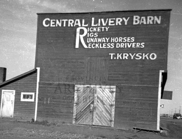
The moose is also historically accurate. It's a reference to a story from the 1930s, when one morning a stable hand unlocked the Central Livery Barn and was shocked to find a moose munching on hay and flirting with the mares. He had apparently wandered in the night before without anyone noticing and been locked in overnight. The stable hand regained his wits and left the doors open until the moose wandered out and back into the wilderness.
Halverson's Beauty Salon Anne Halverson ran this salon from 1945 to 1982. The original building still stands on 103rd Avenue on the other side of 10th Street, just a few feet from where you now stand. Anne was known for the flamboyant pioneer outfits she wore to Dawson Creek's fall festival Bonanza Days, earning her the nickname Bonanza Bonnie.
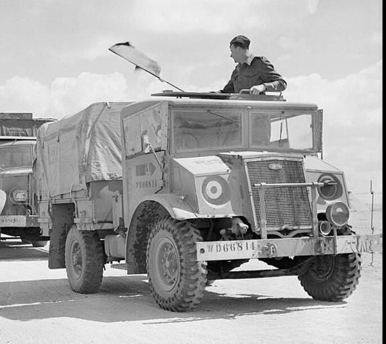
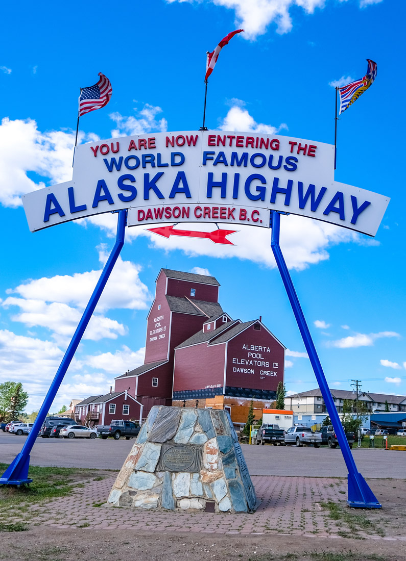
11. The Americans Arrive
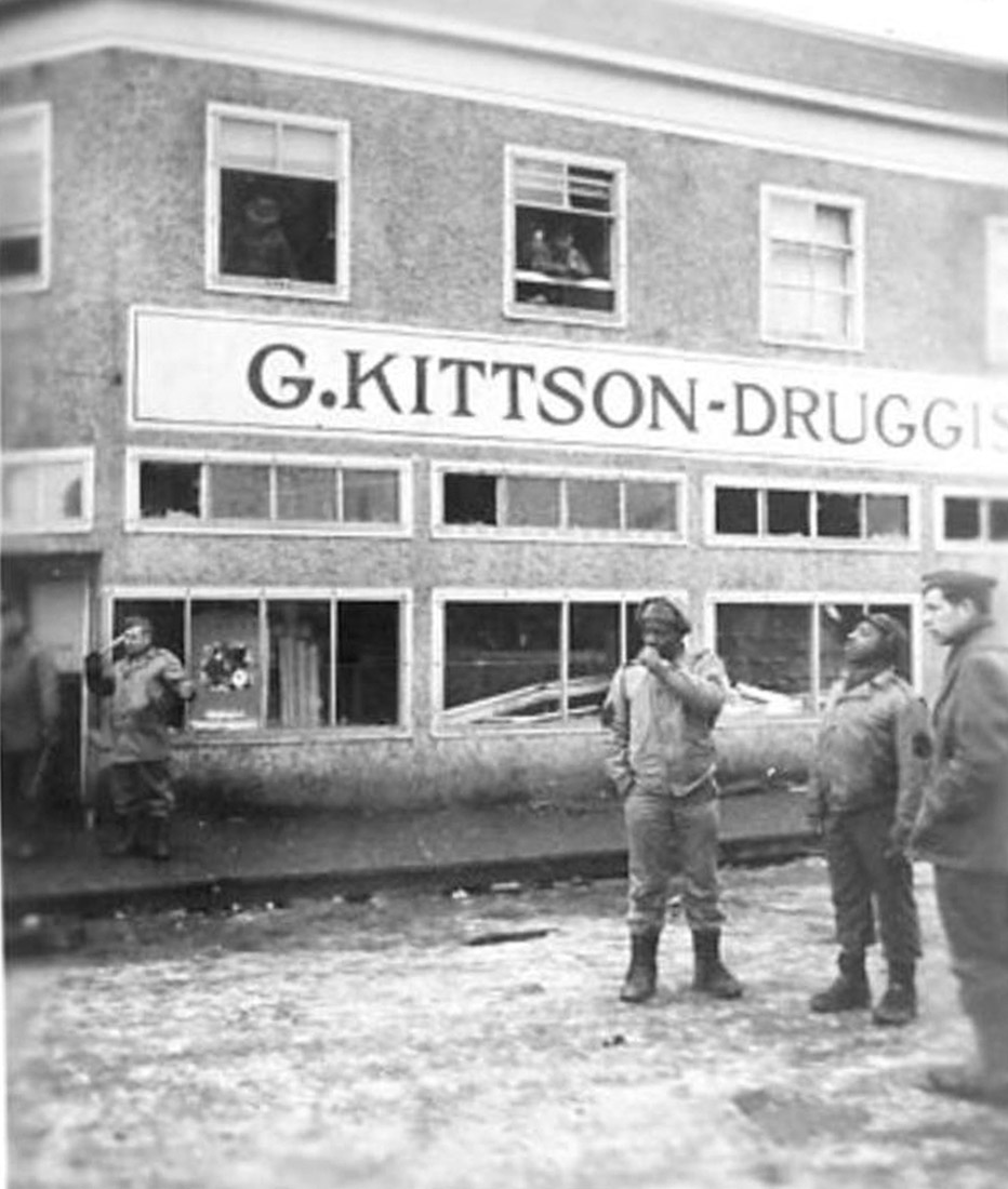
South Peace Historical Society 2001.099.003
1943
This photo from early 1943 was taken at the height of the Alaska Highway building boom. As you can see from the blown out windows in the G. Kittson Drug Store, it was taken in the immediate aftermath of the great explosion that destroyed much of downtown. It shows several American soldiers, amongst them two from the black engineering battalions that helped build the Alaska Highway. These men were subjected to blatant racial discrimination and kept confined to army camps outside of town until their help was desperately needed in disaster relief efforts. This photo likely marks the first occasion these men were allowed into Dawson Creek itself.1
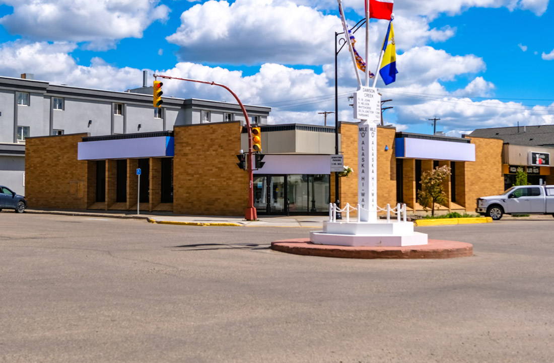
Standing on this corner today, you can turn to the left and see the Mile 0 marker in the middle of the intersection. While the marker wasn't put there until 1946, it remains a permanent reminder of why the soldiers were here.
After Japan attacked Pearl Harbor in 1941, the Americans realized that Alaska was virtually defenseless and easily cut off by sea. They needed a land connection to the far north so they could send troops and supplies to fend off Japanese invasion. As Dawson Creek was the end of the rail way, it was the natural starting point for this highway. Thus it became Mile 0. In an atmosphere of wartime urgency, a titanic construction effort began and Dawson Creek was at its heart.
* * *
Starting in March 1942, Dawson Creek was overrun by Americans, who set up sprawling tent camps on the eastern side of 8th Street. Some of the Americans deployed were from segregated black units, as we see from the above picture. In just eight months they succeeded in punching the highway through five mountain ranges and over innumerable rivers and creeks.2
The historian Dorthea Calverley describes the impact these years had:
"The effect of the influx of American servicemen on the North was in one sense permanent — it sped up the development of these communities by perhaps ten or twenty years. The presence of a large floating population nearly equal in size to that of Victoria or Saskatoon literally forced civilization on the North. It is a maxim of the United States Government that nothing is too good for the American soldier and when he wants something he generally gets it. Thus, roads, hotels, motion picture theatres, stores, hospitals and modern sanitation sprang up almost overnight where the soldiers were stationed.
"The southern base of construction operations on the Highway was Dawson Creek… With 518 inhabitants at the 1941 census, Dawson Creek had a resident population of 5,000 at the height of the boom. Thousands of American soldiers, truckers and construction workmen were located along the Highway between this village and White Horse. The influx of population severely taxed the water supply and showed the inadequacy of the sanitation system. Water was accordingly brought in from the Cut Bank River, twelve miles away, and modern sanitation methods were adopted."3
The highway was taken over by the Canadian Government in 1946. Today over 300,000 people visit it every year, starting in Dawson Creek and ending in Delta Junction, Alaska, via Whitehorse in the Yukon.
You can learn much more about the Alaska Highway in On This Spot's accompanying driving tour.
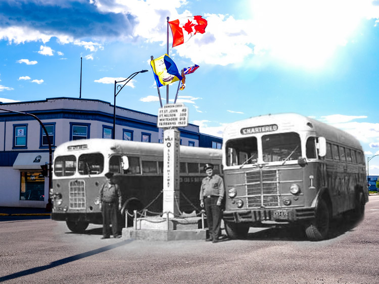
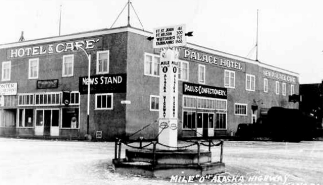
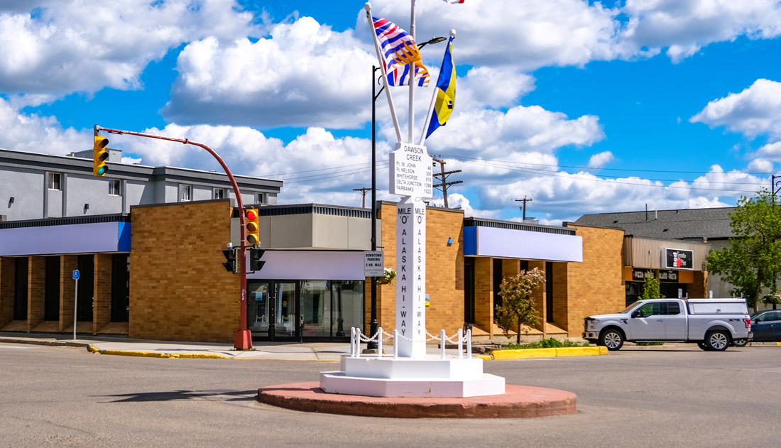
12. The Mile 0 Post
South Peace Historical Society 2001.027.008
1947
The Mile 0 Post the year after its unveiling on Christmas Day 1946. Technically this isn't the spot that surveyors officially designated as Mile 0. That is at the roundabout at 8th Street and Alaska Highway, where the Surveyor Statue is now.
The official Mile 0 was initially marked by a non-descript four foot tall marker. But when it was run over and destroyed by a car in 1946, Dawson Creek's Jaycees, the Junior Chamber of Commerce, had an idea. They thought they could capitalize on tourist interest in the highway by making a more photogenic mile post and moving it to a more lucrative location.
* * *
"Mind you, we never had any idea how well it would catch on," said Ellis Gislason, the man who painted it. The new mile post immediately became the symbol of Dawson Creek. When the president of Canada's Jaycees visited town, Gislason made him a miniature milepost. Before he knew it he was inundated with requests for mini mileposts from local organizations and from tourists. Gislason soon found himself and his wife mass producing tens of thousands of them to keep up with soaring demand.
The Mile Post also attracted some unwanted attention. "'It wasn’t fastened permanently either and on Halloween kids used to steal it… they even put hay on it and tried to burn it once,'" Gislason recalled. "One Halloween the post had been loaded into a truck and replaced with a wooden privy. It [the milepost] was later found hidden under the Pouce Coupe bridge."1
The people of Dawson Creek weren't the only people living along the highway who developed a nostalgic attachment to the mile markers. The annual tourist guidebook for the highway has been called the Milepost ever since it was first published in 1949. The mile marker became shorthand for landmarks all along the highway, from Mile 0 all the way to Mile 1,523. This attachment persisted despite the continual rerouting and straightening of the highway, so that even though today it is 1,488 miles long, the landmark in Fairbanks, Alaska, is still Historic Mile Post 1,520.2 And even though Canada switched to the metric system in 1975, Canada's Alaska Highway communities stubbornly cling to the mile rather than kilometre designations.
13. Lawrence Meat Market
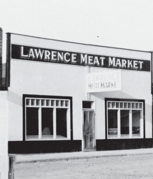
South Peace Historical Society
ca. 1940s
On this spot you can see the Lawrence Meat Market, a Dawson Creek institution. Glover Lawrence first founded it in nearby Rolla in 1931. Realizing that the railway was not about to be extended to Rolla, he saw which way the wind was blowing and moved to Dawson Creek in 1940. The family-owned butcher has remained here ever since. Though the retail outlet you see in front of you today is called the Butcher Block, it's still the same Lawrence Meats.
* * *
Glover ordered a Model T from Vancouver for $100 (about $2,000 today) and had it shipped to Dawson Creek by railcar. Glover's wife Jean fondly remembers teaching their daughter Georgene to drive at the age of 5, and learning how to repair the loose rubber gas line with string and a bent hairpin.
Like everyone else in Dawson Creek, the Lawrences had their lives transformed by the building of the Alaska Highway. The huge influx of hungry men was beyond anything they could have imagined and they struggled to meet demand, a situation made worse by rationing quotas that prevented them from selling more meat than they had before the war. Eventually these regulations eased and the Lawrences bought their own 80 acre lot just north of town to start raising their own cows.
The great explosion of February 1943 blew out the windows of the Meat Market, but thankfully it was spared the worst of the damage. Jean remembered: "What a wreck that made of even the part of 102nd Avenue that was not burned. Everyone in town suffered from shock. People were lost, injured and transported to hospitals in Edmonton, without the knowledge of their relatives. The American Army took over the control of the town and tried to prevent looting."1
Nevertheless, they swept up the glass and got back to work. Business was booming. They took on more employees, including Joe Lafond in 1943. In 1944 Joe and his wife Irene (who had met Joe while working as a secretary for Lawrence Meats) bought shares in the business. 12 years later the Lafonds would buy Lawrence Meats outright.
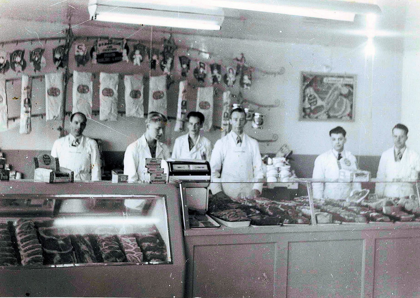
Joe was ambitious and business-minded, and as soon as the war was over he oversaw the construction of a modern abattoir on their lot outside town. Over the decades that followed they continued expanding their facilities, and added a Butcher Block retail store in Fort St. John.
Today the Lawrence Meat Packing Co. is still owned and operated by the Lafond family, and "focuses on serving BC and the Peace River area in particular." They take pride in their deep local roots, saying "Our focus is on quality, price and service. We also maintain that it is our staff and our valued customers that have made this company a success over the many years (decades!) we have been in business." 2
14. The Post-War Boom
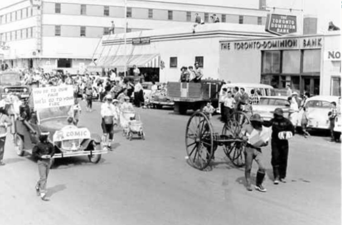
South Peace Historical Society 2000.072.056
1961
People line 102 Ave to watch a parade pass by the Toronto Dominion Bank building, which today has expanded to encompass a larger section of the block. For the young town of Dawson Creek, the late 1950s and early 1960s were a remarkable period of rapid population growth, economic prosperity, and infectious optimism.
* * *
"Hardly more than a quarter of a century old," it reads, "vigorous, fast-growing Dawson Creek breathes the heady atmosphere of growth and expansion, offers unlimited opportunities and comfortable living."1*
In 1941 the town had a population of 518. By 1956, 15 years later, it had exploded 15x in size, to 7,500 (In 2021 the population was 12,323, an increase of 1.6x in the 70 years since 1956). 2
Dawson Creek's once muddy, frontier-style streets had given way to "broad main thoroughfares," and the town boasted "a broad variety of business places, catering to the varied wants of buyers seeking everything from a dinner jacket to a souvenir to a ponderous piece of industrial machinery."3
This economic prosperity was built upon the town's strategic location as a transportation hub for Canada's far northwest and Alaska. Major trucking companies set up their headquarters in the town, and a new railway, the Pacific Great Eastern, at last linked Dawson Creek with the rest of British Columbia. Natural gas was beginning to be found in the region, a sure sign of things to come; Dawson Creek was the first community in British Columbia to be supplied with natural gas.
Yet above all, "agriculture is still the backbone of the district's economy," wrote the Chamber of Commerce, "and "Dawson Creek serves as supply centre for this rich sprawling farm country."4
15. The Hotels
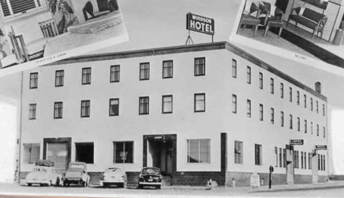
South Peace Historical Society 2000.011.009 Series 04
ca. 1950s
This is where the Windsor Hotel once stood. Built in 1951 at an eye-popping cost of $250,000 (nearly $3 million today), the Windsor came to represent Dawson Creek's postwar prosperity. It advertised itself as the "Northland's Finest Accommodation."1 This was the age of mass car tourism, and this image is from a postcard which would have been sold to those first car-borne tourists. The Windsor was a popular spot for them to get a good night's sleep in a comfy bed before beginning their long journey along the Alaska Highway.
* * *
In keeping with the times it had two beer parlours—one for men and another for ladies and their escorts. In the 1950s a single room would go for $2.50 a night ($30 today) and a double for $6 ($70 today).
The Windsor fell on hard times and by the 2000s it was in a state of disrepair. After property taxes went unpaid, the City of Dawson Creek took over the hotel but failed to find a new buyer. In 2005 the hotel was demolished, an event that many people turned out to witness.2
16. Carlsonia Theatre
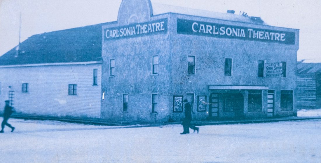
South Peace Historical Society 2000.051.064
1940
We see here the Carlsonia Theatre in the winter of 1942. It went by several names over its brief life: the Opera House and, after a change of ownership in 1946, the Northland. It was the town's first, and, for a time, only movie theatre.
Keen-eyed observers, like the future historian Dorthea Calverley, hailed the opening of the 450-seat Carlsonia in 1936. Amidst the doldrums of the Great Depression, she saw it as symbolic of the town's rapid development and growing self-confidence in the five years since its founding.1
The theatre was heavily damaged in a fire in 1948 and finally demolished in 1951. Other theatres like the Vogue in 1949, the Crest in 1956, and the Ranch Drive-In Theatre in 1959, all stepped into the gap to fulfill people's insatiable demand for Hollywood blockbusters.2
* * *
For these recent arrivals, the movie theatre provided one of their only connections to the outside world. It was a balm for their homesickness and boredom. Phyllis Lee Brebner, who worked on the Alaska Highway as a civilian contractor in Fort St. John, recalled how visits to the packed movie theatre there was the most popular diversion that everyone looked forward to.
People in those days didn't just come to the theatre for entertainment, but to be informed about the war. Movies would be preceded by newsreels that showed dramatic footage from the war then raging on dozens of fronts around the world--a war in which most of the attendees were playing their own small part. The quality of wartime footage was unprecedented and frequently shocking, and viewers often responded with gasps, cheers, and, not infrequently, tears. Perhaps some of those watching a newsreel at the Carlsonia in August 1942, knew someone who had enlisted in the Calgary or South Saskatchewan Regiments, and reacted in horror as they not only learned, but saw, how those units had been practically annihilated in the disastrous Dieppe Raid.
1942 was also when Hollywood was at the height of its golden age, and the movies the Carlsonia would have played that year remain some of the greatest ever made. It is difficult to tell exactly what movie the posters in front of the Carlsonia are promoting, but they look suspiciously like the posters for Casablanca, which came out that year and is still widely regarded as one of the most iconic films of all time. Other classics like Disney's Bambi, Orson Welle's The Magnificent Ambersons, and the quintessential wartime romance Mrs. Miniver would have been shown too.
Given all this, it is hardly surprising that movie demand in Dawson Creek outstripped the Carlsonia's 450 seats, and a couple of temporary theatres were set up in barracks-style Quonset huts, including the Cree Theatre and the Playhouse Theatre. Nor is it any surprise that for those who worked on the Alaska Highway, a trip to the theatre is usually to be found among their fondest recollections of the experience.
17. Police & Fire Brigade
South Peace Historical Society 2001.095.043 Series 01
1945
The police station was located in the building you see in this historic photo, on the corner of 10th Street. Dawson Creek had a small police force at the time this photo was taken. In 1948, a Royal Canadian Mounted Police detachment took over policing and moved into a new station, at the Joe Dill location. Later on, in 1961, the RCMP along with the fire department, moved into the city hall block just a few blocks to the west off Alaska Avenue.
* * *
During the war the US Army was on hand to provide more advanced firefighting equipment, though it was of fairly limited utility when most of the town blew up in February 1943. After the war Dawson Creek's fire brigade continued acquiring increasingly sophisticated and modern equipment, and today the fire department is equipped to handle whatever conflagrations may arise.1
18. The Department Stores
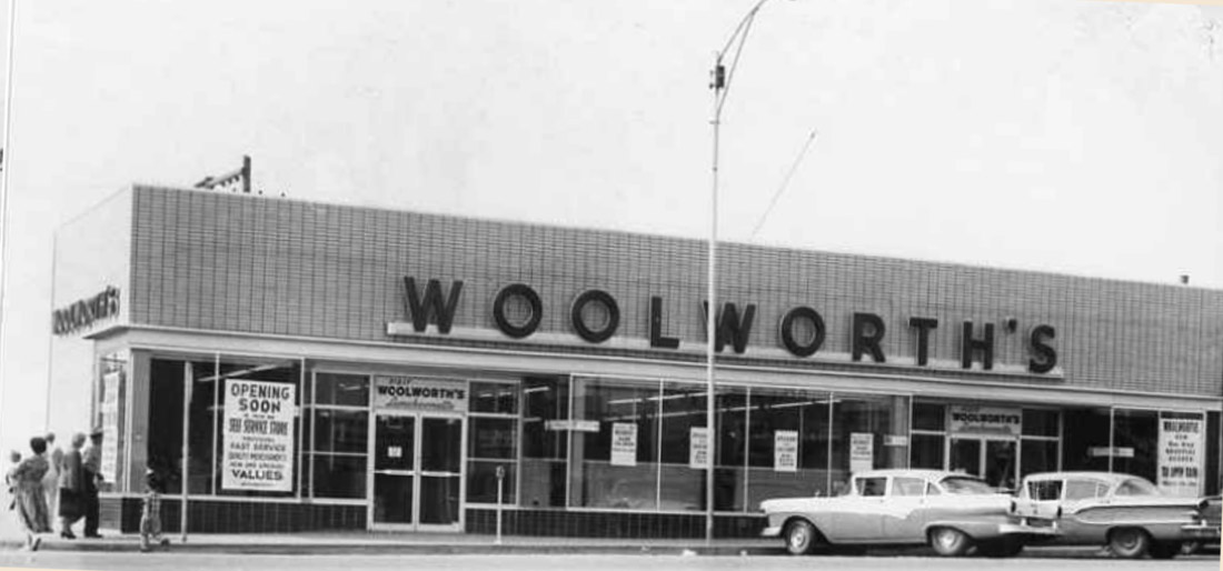
South Peace Historical Society 2000.011.010 Series 04
1959
A Woolworth's Department Store once stood here, built just after the Second World War. Just the next block over, the Hudson's Bay Company also opened a large department store around the same time. These were yet another indicator of the growing prosperity of Dawson Creek in the post-war boom years.
* * *
19. Harper's General Store
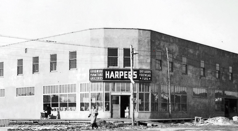
South Peace Historical Society
ca. 1930s
Here we see the second Harper's General Store. It was named after its proprietor W.O. (Wes) Harper. Wes, along with his father and four brothers, were some of the first homesteaders in the district, moving here from Vancouver in 1914. Wes, who went off to fight in the First World War, began managing the general store at Dawson Creek's old townsite. Soon after he purchased the store outright, renaming it W.O. Harper General Merchant. In 1931 he had it moved on skids to this location. He sold this lot in 1942 and moved a block south, running his store there until he sold it to the Hudson's Bay Company in 1952.
At the Walter Wright Pioneer Park there is a replica of Harper's General Store as it would have appeared at the old townsite. Carefully recreated from old photographs from the time, it is a remarkable time capsule of life in Dawson Creek's first days.1
* * *
It was in 1908 that he first heard about the wonderful land to be had in the Peace Country for $10 a quarter section (about $0.16 an acre).
"It became the subject of many discussions led by my father who had homesteaded in Manitoba in the 1880’s and still had the pioneering spirit and was encouraged by five boys who were no doubt looking for adventure more than land."
They heard about the first settlers arriving in 1912, and even though "Information regarding this great country was limited and was mostly hearsay," the Harpers did not want to be left out. The next year "My father sold our house and took in payment two teams of horses and harness."
Wes rode to Edmonton in a boxcar with all the family's possessions, frequently enjoying the company of unemployed men riding the rails. Upon arrival in Edmonton his mother came down with pneumonia, and tragically passed away. "Knowing that it was her wish that we should go to the Peace River we decided to go on." At Edson they reached the end of steel and switched to horse-drawn sleighs.
With them they carried a year's worth of food, some rudimentary farm equipment, and "just the most necessary household effects such as blankets and mattresses." In those days this was enough to start a new life on a snowy remote prairie. It was February 1914.
It took two weeks to reach Grand Prairie. The exhausted horses struggled on the half-snow covered rutted tracks that passed for roads.
"One place I well remember. Crossing a creek with hills on both sides my dad got stuck on the bridge so I pulled up behind and took my team off to help him. As we were not able to move the load my brother Lester took his team off the caboose, which was at the top of the hill, and came down to help. While we were getting hitched on someone glanced back up the hill and shouted, 'Here comes the caboose'... There was neither time nor room to get the buggy out of the way. Although the caboose was not traveling fast it ran into the buggy and folded it up like an accordion."
They continued ever westwards, sleeping under a tarp in the freezing sleigh, or, if they were lucky, coming upon an isolated homestead that could offer them some respite from the cold. At long last they reached their destination.
"Fortunately," Wes continued, a nearby homesteader had been driven mad, perhaps by the relentless loneliness and isolation, and shot himself. "Bush-wacky," is the term Wes used. "The Mounted Police from Fort St. John were holding a sale of his effects that afternoon." The man had left behind a large barn filled with supplies. The Harpers eagerly purchased it all and moved in. They registered their homesteading claims and started their new lives in the Peace Country. At the time there were only three homesteaders further west of them.2
20. The Hudson's Bay Store
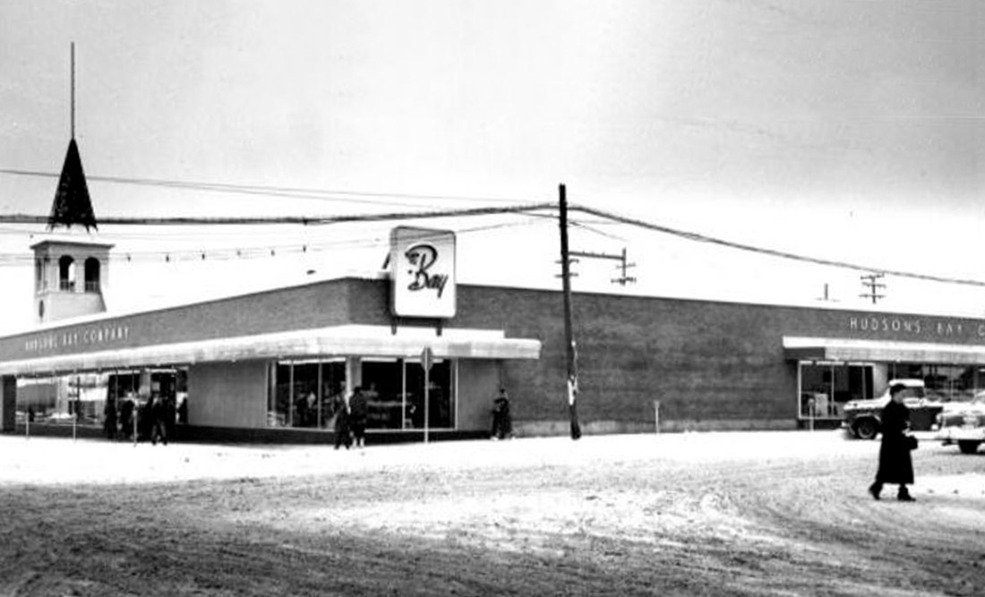
South Peace Historical Society 2000.061.019
1957-65
The Hudson’s Bay Company bought the Harper’s General Store of the 1940s and rebuilt it. The store was a downtown mainstay for years before changing to Zeller’s in the early 1990s. The building has since been remodeled and is home to several unique Dawson Creek businesses.
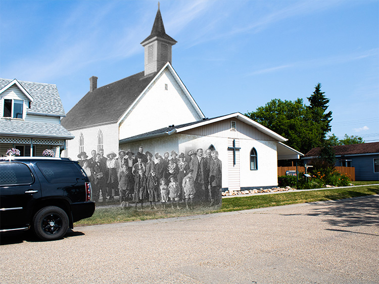
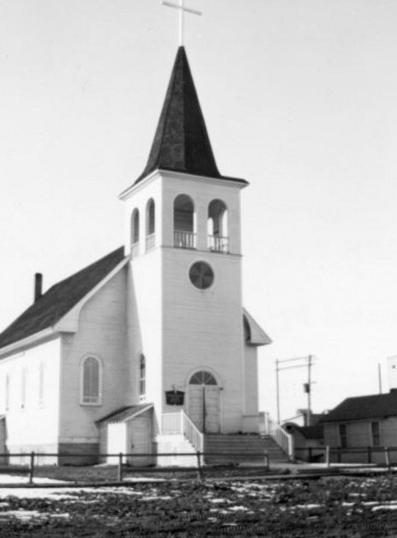
21. Places of Worship
South Peace Historical Society 2000.035.002
This was the Our Lady of Perpetual Help, the first catholic church in Dawson Creek built in 1931. It was demolished in 1965 and the congregation moved to the Notre Dame Parish church just half a block to the west on 104 Ave.
* * *
Once Dawson Creek became established a range of beliefs gained a foothold amongst its inhabitants, though the great majority were followers of one of a variety of Christian sects. Today only about a third of the 12,000 strong population identified as Christian. While many Christians didn't indicate their denomination in the 2021 census, the largest group that did were the Catholics, with 1,500 Dawson Creek residents ticking that box. The other Christian denominations with followings in Dawson Creek were United (350), Lutheran (280), Anglican (255), Pentecostal (180), and Baptist (105). There has been also been a growth in religious diversity in recent years: There are now small populations of practicing Sikhs, Hindus, Buddhists, Muslims, and Jews.1
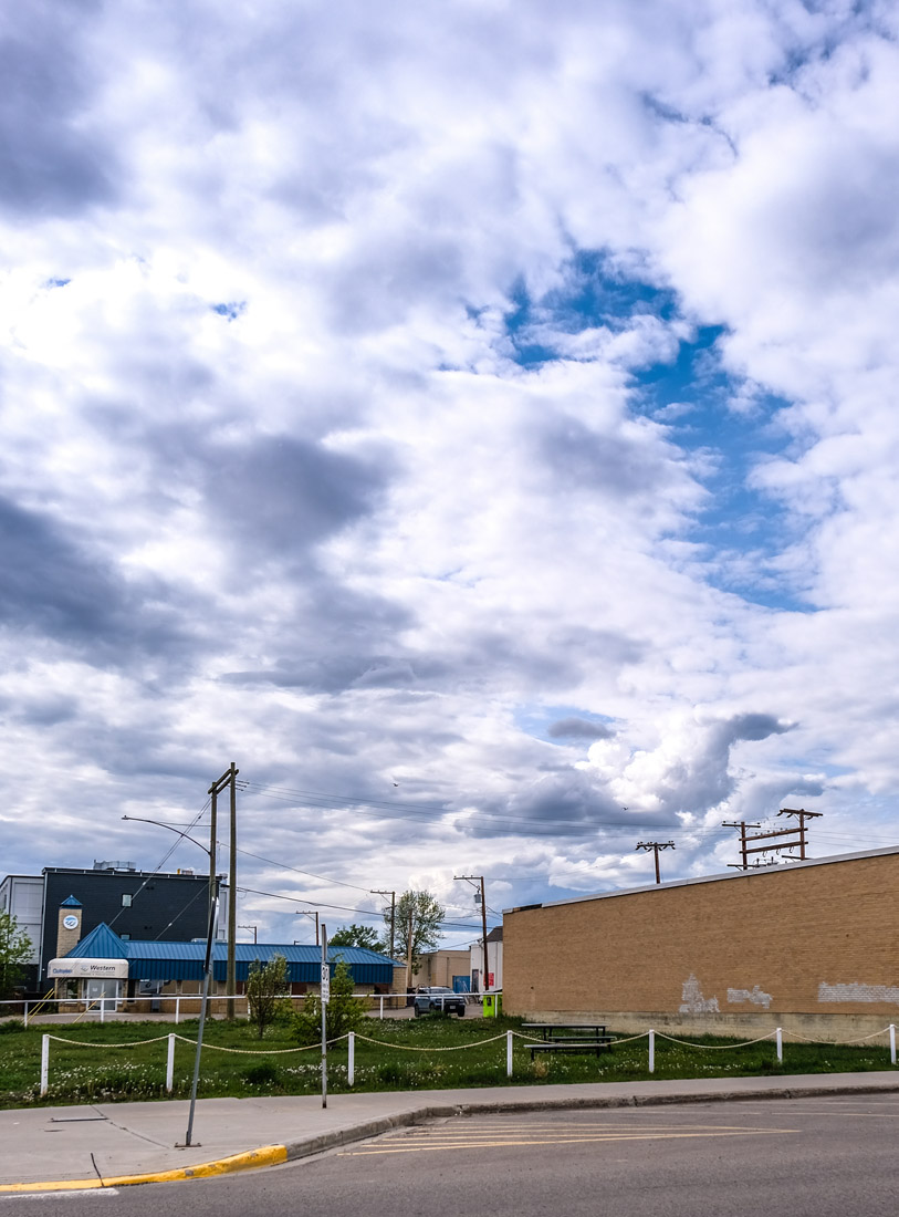
22. Calvin Kruk Centre for the Arts
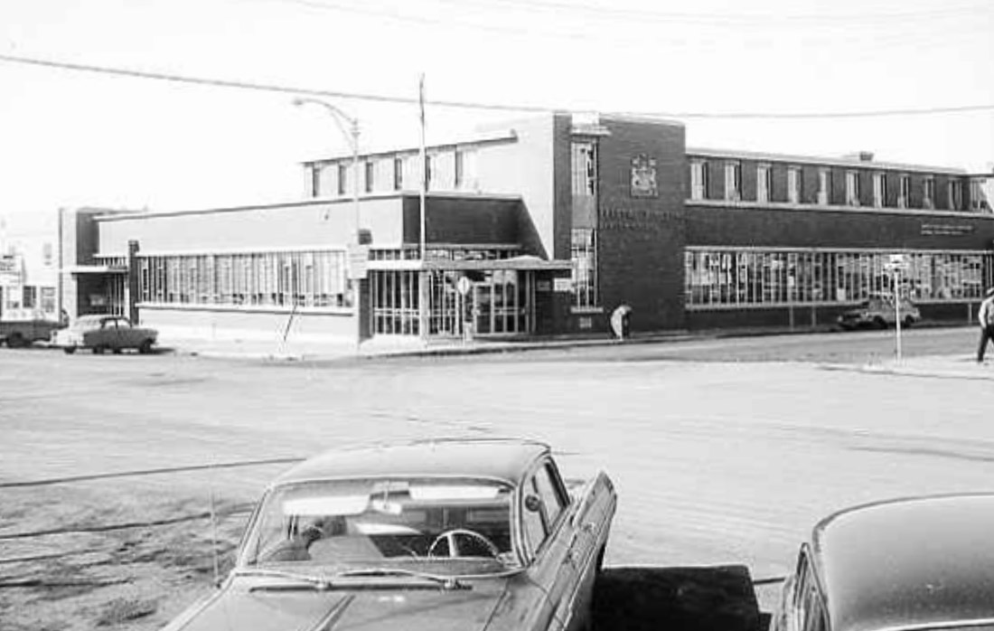
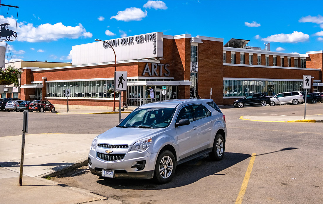
South Peace Historical Society 2000.072.091
1965
Looking back across the intersection we see what was once the federal government's administrative building in Dawson Creek. Today it is the Calvin Kruk Centre for the Arts, named for Dawson Creek's community-minded mayor from 2005 to 2008.
* * *
The facility boasts a variety of dance studios, theatres, and an auditorium. It is your best bet for all the latest cultural exhibitions and performances to be found right in the heart of Dawson Creek.
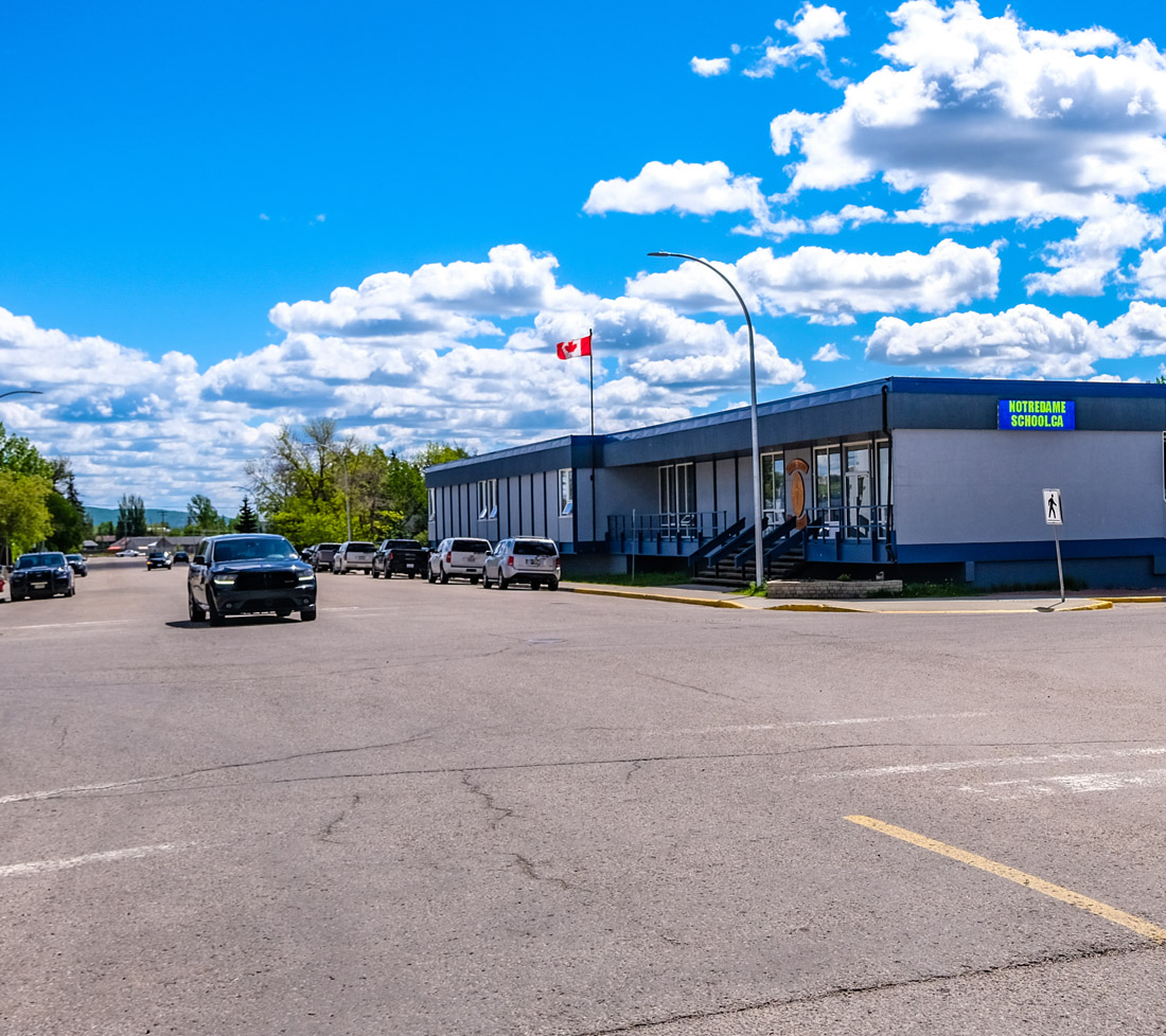
23. Notre Dame School
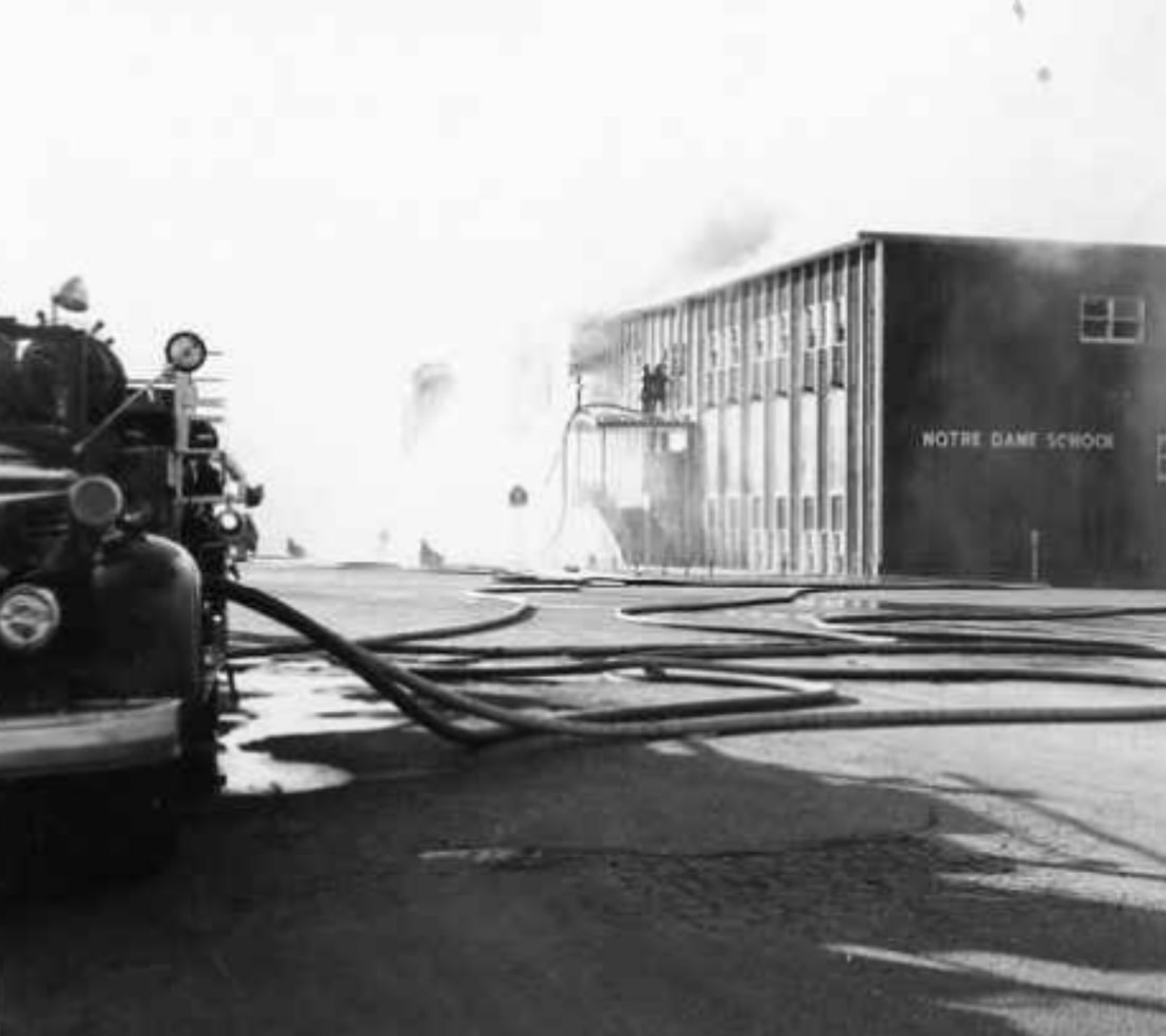
South Peace Historical Society 2000.051.409
1968
In 1968, the Notre Dame School went up in flames. As you can see, it then rose from the ashes. Founded as a catholic school during the Second World War, the Notre Dame school has been a key educational institution in the heart of Dawson Creek ever since.
* * *
In 1945 the school rapidly expanded to 130 students from grades 1 to 8, including 50 students who lived there as boarders. There was so much demand for education in Dawson Creek that the Sisters added grades 9 to 12 and even opened the Notre Dame Business College.
The barracks were always meant to be temporary structures, and so in 1952 the school was moved to a new purpose-built building—the one you see burning here. Through the 1960s the Sisters struggled to keep the school financed. Finally they agreed to give the school to the parish so that they could build a long-desired church.
A history of the school explains what happened next: "Hardly had the pastor announced these glad tidings to his flock on Easter Sunday, 1968 when in the silence of early dawn, Notre Dame School went up in flames. The Alma Mater which had been the joy and pride of its old students was no more."
While classes were temporarily relocated back into the old barracks, construction began on the school you see today. It was financed by the fire insurance payout.
"And so, on the ashes of old Notre Dame and its hosts of memories, a beautiful new school proudly stands — an edifice worthy of the sacrifices of so many of Mother Gamelin’s valiant missionaries who toiled that others might reap so rich a harvest."1
24. Joe Dill's Funeral Home
South Peace Historical Society
ca. 1940s
1958 saw the Royal Bank commence business in Dawson Creek. After two temporary sites, the bank chose this site for its permanent home, which had previously been Joe Dill’s Funeral Home.
Joe Dill was the town's undertaker for much of its early history. Dill had been an early arrival, starting out as a furniture salesman at the old townsite in the late 1920s. Moving to the new townsite in 1931, his funeral home prepared those who had passed to be interred at one of Dawson Creek's two cemeteries: the Dawson Creek Cemetery located to the northwest by Pioneer Park, or the Brookside Cemetery, located a short distance to the southeast of downtown alongside the river.
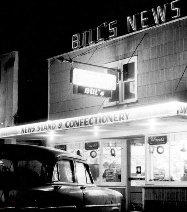
25. Bill's News
South Peace Historical Society
ca. 1950s
Built in 1949, Bill’s News had low ceilings, wooden floors that always creaked, and friendly staff. Here we see it around the 1950s. Back then it sold many of the same things it still sells today: newspapers, magazines, candy bars, ice cream, Players cigarettes.
As you can see, the small creaky building was replaced in 1970 with a new one that continues to this day. Today they have enhanced their offerings with toys and clothing, making it popular with the town's teenagers.
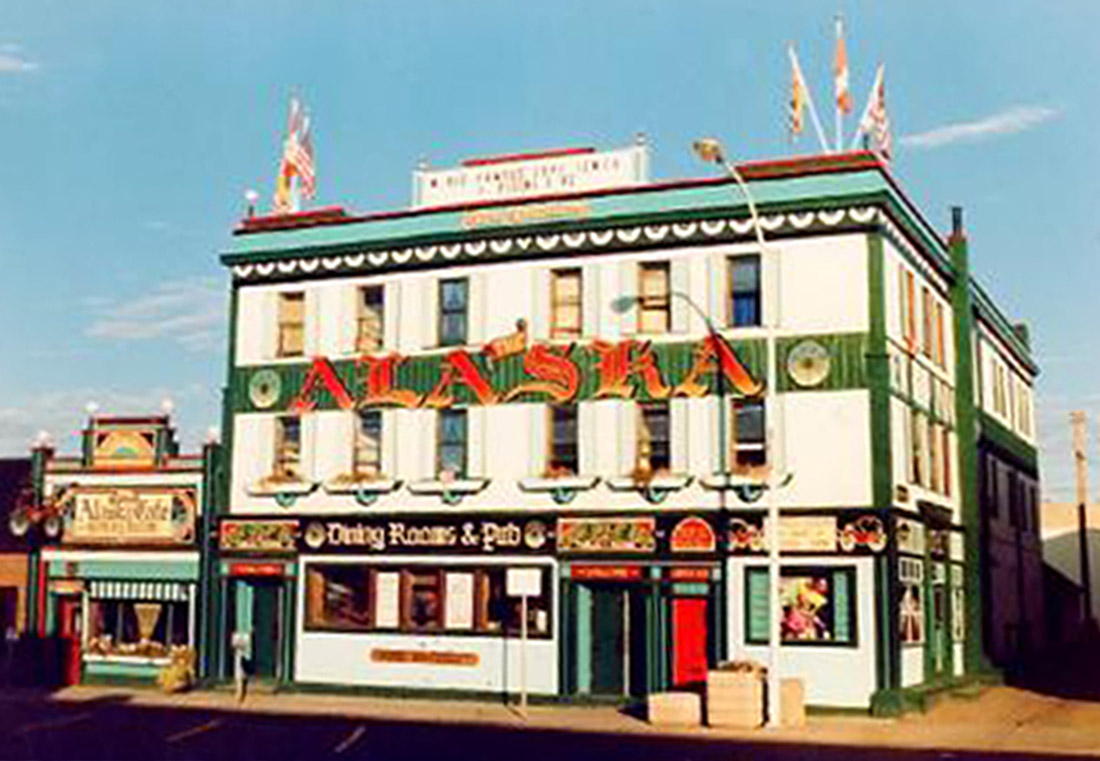
26. The Alaska Hotel
South Peace Historical Society 2022.002.503
1992
This playfully colourful building was the Alaska Hotel, and for decades it was the best known landmark in Dawson Creek--well, after the Mile Post. The hotel was first built in 1931 and known as the Dew Drop Inn. With the arrival of American troops to build the Alaska Highway, the hotel was greatly expanded and given its famous name. At that time it was the only pub in town, and as such became the chief social hub for American soldiers stationed here.
* * *
Sadly, in 2012 the hotel caught fire and burned to the ground. Mike Bernier, mayor at the time, told the CBC that as word about the fire spread, it seemed as if everyone in Dawson Creek came out to watch, and to mourn the loss.
"When I was walking around through the crowd last night, people were quite teary, people were hugging each other… It was quite emotional, especially people who have been in the community for a couple of decades who could really appreciate the historical value of this building… [It's] basically known worldwide as an iconic landmark commemorating the northern part of British Columbia and the Alaska Highway… It is just an incredible loss."2
27. The CIBC
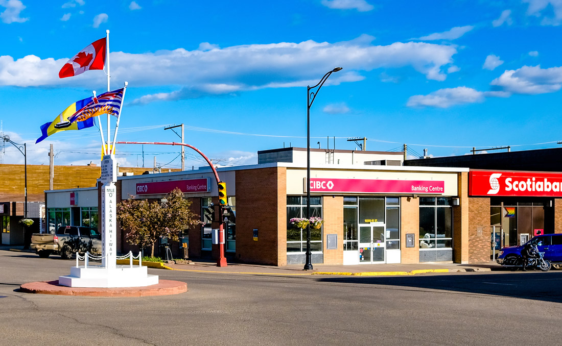
South Peace Historical Society 2000.070.001
1944
On this corner in the centre of town we find another Dawson Creek institution, the Canadian Imperial Bank of Commerce (CIBC), as you can see they have modernized their building in the 80 years since this historic photo was taken. The bank was established in Dawson Creek very early on, in 1929 at the old townsite. Two years later they--like everyone else--moved to the new location that the Northern Alberta Railway had picked for the town. As Dawson Creek's first bank, they have maintained not only this prime piece of real estate in the centre of town, but the loyalty of many who have called Dawson Creek home.
* * *
It took almost 15 years for the village of Dawson Creek to attract enough people and business to warrant its own CIBC branch. When it opened in 1929 it was actually a sub-branch of Pouce Coupe: an indication, if ever there was one, of Pouce Coupe's greater economic importance.
This state of affairs was suddenly turned on its head just a year later when the Northern Alberta Railway came to the Peace and decided that the End of Steel would be Dawson Creek. The CIBC, along with everyone else at the old Dawson Creek, uprooted and moved to the new Dawson Creek.
CIBC could read the tea leaves and was fittingly unsentimental about it. On December 15, 1930, two weeks before the last spike was driven on the railway, they reversed the relationship between the two villages and demoted Pouce Coupe to a sub-branch of Dawson Creek. They were betting that End of Steel was destiny and they weren't wrong. Today Dawson Creek has a population of over 12,000 and Pouce Coupe has a population of around 750. Pouce also no longer has a CIBC.
The CIBC played a crucial role in the other defining event in Dawson Creek's history: when the highway builders arrived in 1942. As a historian in CIBC's Public Relations department wrote, "It was to be expected that a Bank so long established there should be selected as a depository for funds of the U. S. Government administered by finance officers of the United States Army."1
Overnight the bank went from serving a few hundred farmers and shopkeepers in a sleepy backwater to becoming paymaster for over ten thousand highway builders and the thousands of others who came to support them. One can imagine the chaos that resulted. The historian describes it with the kind of sober understatement one would expect of a historian working for a bank:
"It was an everyday occurrence that as soon as the branch opened all the available customers’ space would be filled to capacity. The procedure would be repeated in the evening after the branch had closed for a short interval. Only with an end of the war came a letup in this feverish activity."2
The bank's office was so cramped and ramshackle that it was impossible to handle all the customers and fit all the American money in their vaults. A new building was quickly erected, but this still proved to be too small, so it was enlarged twice in the space of a couple years. The photo you see here above is actually the new bank after its second enlargement, which might give you a sense of how tiny and threadbare the pre-war branch was.
At the height of highway construction CIBC estimated there were some 30,000 to 50,000 people between Dawson Creek and Whitehorse--and most of them needed a bank. CIBC was happy to oblige and set up sub-branches at Fort St. John and Fort Nelson, communities where the bank has remained ever since.
28. Trail of 42 Mural
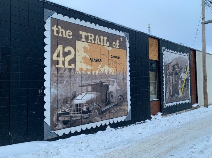
Shannon Tilley and Terri LeGear
These three panels depict scenes of the formidable terrain faced by the engineers and their machines during construction of the Alaska Highway. The panels were painted in 2003 by Shannon Tilley and Terri LeGear. They were working off of photographs featured in the popular 1979 book The Trail of '42: A Pictorial History of the Alaska Highway by Stan Cohen.
You can learn more about the grueling conditions these men endured in On This Spot's accompanying tour: Driving through Peace Country: Dawson Creek to Kiskatinaw Bridge.
* * *
America's cultural dominance of the popular memory of the Second World War, through its movies, TV shows, and reenactors, might lead one to assume that the Canadian army also used American deuce-and-a-halfs, or that Canadian automakers manufactured identical trucks to their American counterparts, much as they do today. In actual fact, Canada had more than enough trucks of its own and they looked quite different. These trucks are one of the largely forgotten parts of Canada's Second World War.
They were known as the Canadian Military Pattern (CMP) truck and Canada made over 800,000 of them. Canada made more of them than all the trucks made by all the axis powers of Germany, Italy, and Japan combined. The British and Commonwealth armies were almost entirely equipped with CMP trucks. The UK's official History of the Second World War called CMP trucks Canada's greatest contribution to ultimate victory. By war's end the Canadian army had more trucks per soldier than any other army, making it effectively the world's most mobile army.
Yet since the Canadian Army played barely any role in the construction of the highway, in Dawson Creek in 1942 you might have been hard-pressed to find a CMP truck. Instead there were at least 5,000 deuce-and-a-halfs brought here by the US Army Corps of Engineers, lined up hubcap to hubcap in huge motor pools in and around town. And so it was these American trucks--and their American operators--that were etched into Dawson Creek's collective memory.
29. Mile 0 Hotel
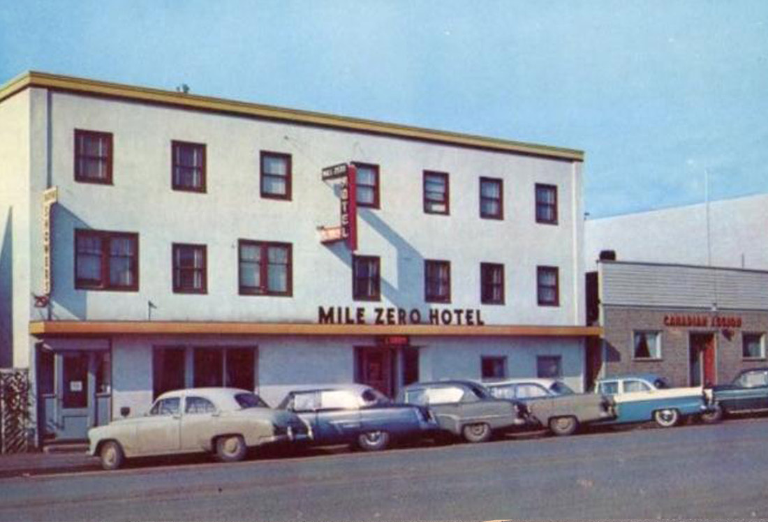
South Peace Historical Society 2000.061.021
1964
This is one of the oldest hotels in Dawson Creek. Its first name was The Red Apple. Over the years, it's had many other names: Maple Leaf, Shangri-La, Spanish Grill and then in 1945, the Blue Bird Hotel & Café.
The Red Apple used to have a distinctive sign with certain negative connotations that shocked Dorthea Calverley when she first came to Dawson Creek in 1936--so much so that she almost left the town forever. It's a good thing she didn't as she would later become Dawson Creek's most prolific chronicler and without her we'd have precious few archival records to go off of in creating this tour.
* * *
"Why ever not?"
"Well, LOOK!" I said, "I know there is vice in every place, but this is the first small town where I’ve seen it advertised openly!"
"Where do you see it advertised?" he asked.
"See! Right there where it says "Hotel."
"Oh" he said, amused. "That red spot? what do you think it means?"
"Of course!", I replied — probably blushing a little. "A Red Light district?"
"Look a little closer."
Now "The Red Apple" might be an unusual name for a hotel but it was innocent enough. In any case the purity of the "Dew Drop Hotel" sign hung a short distance south of the corner, so I consented to stay.1
30. Tuning In to CJDC
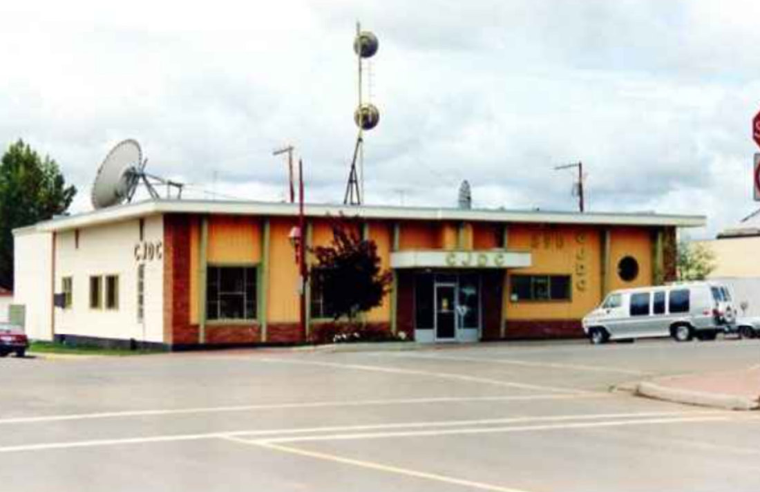
South Peace Historical Society 2001.101.271 Series 07
Here is Dawson Creek's iconic radio station CJDC, which can be found on your dial at 890 AM. CJDC has been keeping the people of the Peace River Country informed and entertained ever since it first began transmitting in December 1947. The new radio station was greatly welcomed by the town's residents since up to that point the only signal they could get was a faltering and staticky broadcast from Grand Prairie's CFGP—some 110 km distant.
* * *
"It had been a long, hard, painful birth, but it had taken place. The youngster was born live and healthy and was well received, too. And, although there were setbacks of one kind or another in the first few months, these were strictly internal, and were eventually resolved. The station went on to success.
"A Radio Drama Group was formed and read 'productions' with varying success, but great enthusiasm. Public Forums discussed the issues of the day. Local people commented on local topics and pursuits, local artists performed. Somehow the announcers seemed to read more fluently. In a day when hitherto unheard of foreign names popped into every newscast, somehow the broadcasters seemed to be able to cope with them.
"At that time we were the farthest north radio station in the British Empire. Dawson Creek had come of age – it had its own radio station. At that time Dawson Creek was only a village of approximately 3,300 people. No wonder everyone was proud of it."1
31. Army Headquarters
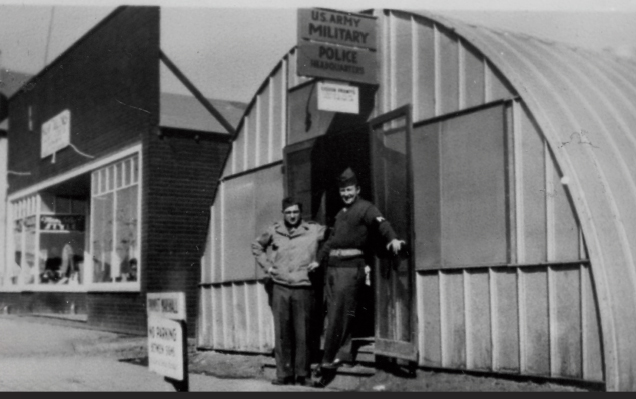
South Peace Historical Society
1942
In 1942, next to the site of the original Peace River Block News, the army set up a Quonset hut for its military headquarters. Huts like these were easy to manufacture and build and used by the thousands by the US Army during the construction of the Alaska Highway.
* * *
Those working in these camps lived a life of monotonous routine. Phyllis Lee Brebner worked as a clerk in a highway camp and recalled how she and the other clerks slept 18 to a room. Oil powered space heaters kept them warm in winter, and poor plumbing meant they had to melt snow for their water.
While they all shared in the spirit of adventure, Phyllis recalls the pangs of homesickness they all experienced, especially when the mail arrived. "Among the things missed most of all was a bathtub, an ice cream sundae, and a house with an upstairs (a symbol of privacy)."
They did have a few diversions: walks around town, poker games, and a film at the theatre. And there were of course the dances. Phyllis and the small number of other women working on the highway were "very popular with both male civilian workers and army personnel and never lacked for dates."
At a camp in Fort St. John, one Toronto office girl became engaged to a US airman after they met at a dance at the Red Cross hut. For Phyllis, their wedding at the Anglican Church was one of the war's most memorable occasions.1
32. The Local Newspaper
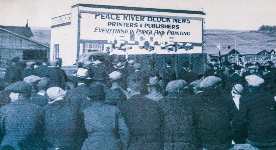
South Peace Historical Society 2000.051.049
1939
A crowd gathers outside the offices of the Peace River Block News in the mid-1930s. The Peace River Block News went by several names over the course of its life, and served as the paper of record for the Peace Country from the founding of Dawson Creek in 1931 to the paper's closure in October 2023.
* * *
By 1970 the News boasted a circulation of 5,300 and a staff of 22. In the 1970s the Kitchen family sold the paper to new owners, who in turn brought it under the control of Conrad Black's media empire. It was still an era of growth in the newspaper business, and the News began to be published bi-weekly and then daily.
Sadly, these days were not to last. In 2006 the paper was sold to Glacier Media, who renamed it the Dawson Creek Daily News.1
Glacier Media had bought up many local papers across the province and they struggled to cope with the rise of the internet and the subsequent collapse in revenues from print advertising. In a bid to cut costs they amalgamated the Daily News with another one of their other properties, Fort St. John's Alaska Highway News. The Alaska Highway News would now serve as the paper of record for BC's Peace Country. Glacier also spun off a weekly edition aimed just at Dawson Creek called the Dawson Creek Mirror.
Despite successive and ever deepening rounds of cuts, Glacier Media failed to turn the ship around. In 2023 they pulled the plug on the entire operation and they permanently shuttered their newsrooms in the Peace region. The Alaska Highway News and the Dawson Creek Mirror published their final editions on October 13, 2023, ending a 93-year story that traced the entire history of Dawson Creek.
"I'm sorry this company could not keep your paper going," wrote The Mirror's managing editor Rob Brown wrote in a farewell letter.2
The closure of these papers, along with the independent Fort Nelson News around the same time, has left the entire Peace Region without a newspaper.
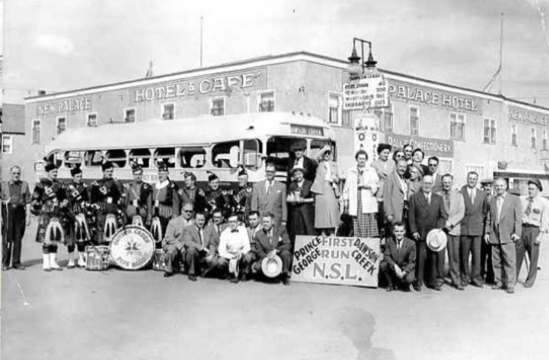
33. Connecting with British Columbia
South Peace Historical Society 2000.051.170
1953
Returning to the town's central intersection of 10th Street and 102nd Ave, we see a beaming group of men and women as well as a pipe band, a Northern Stage Lines bus, and the iconic Mile 0 marker. These are the staff of the Northern Stage Lines company and they are celebrating the inauguration of their bus service to Prince George.
* * *
This state of affairs finally came to an end in 1952, with the completion of the 405-km John Hart Highway to Prince George. It was named for British Columbia's Second World War-era premier who had championed its construction. The Alaska Highway project, recent discoveries of oil and gas, and the enormous hydroelectric potential of the Peace River, had finally drawn the attention of the provincial government in Victoria. They were moving at last to integrate the Peace Country with the rest of the province.
The John Hart Highway connected Dawson Creek and its surrounding Peace River Country with Prince George, and from there the province's population centres far to the south and west.
An accompanying rail link to the rest of the province would take even longer. The Pacific Great Eastern Railway, which also ran to Prince George, would reach Dawson Creek in 1958. High voltage transmission lines, and oil and gas pipelines would soon follow. It had taken almost a century, but the Peace was becoming an integral part of British Columbia.
34. Bank of Montreal
South Peace Historical Society 2021.026.173
1947
Since 1930 this site has seen many changes: from a small general store, to W.O. Harper's General Store, to the New Palace Hotel and Cafe, to an empty lot, to the present day Bank of Montreal.
Here we see it in its days as the New Palace Hotel and Cafe. The New Palace was opened in 1943 by Mah Show and Mah Fong, members of Dawson Creek's small Chinese community. The hotel stayed in business until 1967.
35. Aerial Links
South Peace Historical Society 2001.015.011
1944
A crowd of onlookers has gathered in front of the Dawson Creek Co-op to watch a detachment of Royal Canadian Air Force service members parade down the town's main street during the Second World War. Notice the Union Jacks and Royal Canadian Air Force (RCAF) flags at the left of the historic photo.
* * *
As the terminus of the Alaska Highway, Dawson's Creek airstrip would be used to ferry in and out high priority construction supplies and VIPs. It was also a link in the chain of airfields that composed the Northwest Staging Route. This scheme allowed lend-lease supplied fighters and bombers to be flown straight from American factories to the Soviet Union, crossing Canada, Alaska, and the Bering Sea along the way.
The airfield was operated by the RCAF until it was shut down at the end of the war. The base was briefly reopened from 1956 to 1964 as part of the Mid Canada Line, a Cold War-era chain of radar stations to provide early warning of incoming Soviet bombers.1
Dawson Creek's civilian airport was opened in 1958 at a new location, to the southeast of the town, where it continues to operate to this day.
36. Silverado Inn
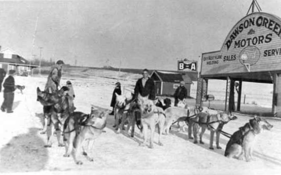
South Peace Historical Society 2000.051.091
1941-2
Here we see several dog teams harnessed up ready to be mushed across the snowy prairie. They were once a common sight in Dawson Creek, one of the most efficient forms of winter transportation. To their right is the storefront of Dawson Creek Motors, which once stood on this spot. It was for many years the only car dealership in town. This corner lot was also home to the Empress Hotel and a small cafe. All of this space would eventually become the Park Hotel in the 1960s. Currently it operates as the Silverado Inn.
* * *
For much of the first half of the 20th century most of the roads around the Peace River District were little better than dirt trails that saw more horses than cars.
Driving the road east to Edmonton--the closest thing to a 'highway' Dawson Creek had--was a white knuckle affair. Dorthea Calverley drove it three times in 1934 and "for miles, speed never exceeded 15 miles an hour. The mud was so slippery that sometimes the car spun end-for-end its own length."
For travelling north there was "A gravel road of sorts," to Fort St. John. However, crossing the mighty Peace River was a challenge. There was a ferry during the summer months, and it could be driven over when it froze in the winter, but "There was always a period in spring and fall when the river ice was not fit to bear a load and the ferry could not run. Those living over-river were completely isolated. It was a terrible hardship — dangerous too, until the Sisters of Providence opened the hospital at Fort St. John."
Highway shoulders might seem a pretty obvious innovation, but they were completely unknown in this region until long after the Second World War. Calverley recalls driving the single lane hairpin track to Hudson's Hope in 1955, a road with an infamous and dangerous reputation nicknamed 'The Hump'. She found it was still just as terrifying an experience as it had been 20 years earlier.
"Meeting another vehicle on a high grade when both were zig-zagging across two lanes like a couple of DDT’d flies, was a breath-holding experience. You also passed another vehicle on a grade at the risk of going down-side off the left hand track. Gravel was simply eaten up by the clay, not that there was much to devour!"1
Winter presented another problem. Clarence Tibbetts recalls her "astonishment at the height of the snowdrifts" while driving near Rolla.
"After each storm the roads would be packed with many feet of snow. Many times the snow plough crews worked through the night to keep a tunnel open and they would pile the snow to great heights. I know of at least one baby born behind the plough, as the crew struggled to make a hole in the wall of snow."2
37. Harnessing New Energies
South Peace Historical Society 2000.041.156
ca. 1950
Returning to N.A.R. Park, we are just about to wrap up this tour. Along the way we have learned about the many different people, ideas, and technologies that have shaped Dawson Creek. There remains one major development over the last 50 years we haven't yet mentioned: oil and gas.
* * *
Alberta developed their gas deposits quickly, and in 1950 an Alberta company started to pipe natural gas to Dawson Creek for domestic use. This made it the first town in British Columbia to get a gas hookup. Engineers had only recently figured out how to harness this powerful new fossil fuel for use in the home, and people still didn't know much about it.
So the turning on of the gas in Dawson Creek was met with much fanfare. This included an impressive gas flare at the Mile 0 Post, a heavy promotional campaign for gas appliances, and "free lessons to housewives wanting to cook with gas but unsure how the new fuel would behave."1
Just a year later the Pacific Petroleum Company struck oil in the Peace. The well, however, was located up the highway in Fort St. John. Fort St. John was a much smaller community, and it had only just been connected to the outside world by the Alaska Highway less than a decade before. The discovery of nearby oil and gas fields slingshotted its growth ahead of Dawson Creek, and it became the heart of British Columbia's nascent oil and gas industry.
Using North-West Tel phone books, Gerald Clare, president of the South Peace Historical Society, found an interesting way to track Fort St. John's rapid relative growth. He noted that in the 1957 phone books, "while Dawson Creek had fairly modern phone numbers like Sterling 2-3938 the numbers in Fort St. John were likely to be just something like "218". Dawson Creek was by far the larger and more important town in the Peace at the time."
"In that year the phone books for "Dawson Creek and Fort St. John listed about 25 companies in the Oil and Oilfield Service categories for each community…. Six years later, Dawson Creek showed a small decline in numbers while Fort St. John was home to about 65 such companies. The movement of the oil companies to the fields north of the Peace River was well underway and continued for the following 40 years."2
Since 1960, Dawson Creek's oil and gas sector has grown up around the Montney Formation and the development of liquified natural gas (LNG) export technology. However the runaway success of the fossil fuel industry has driven even more rapid growth in Fort St. John. This has ultimately meant Dawson Creek has a more diversified economy, with large employers in a variety of sectors including transportation, agriculture, timber harvesting, cattle ranching, and wind energy.
38. Exploring Dawson Creek
South Peace Historical Society 2003.001.T090
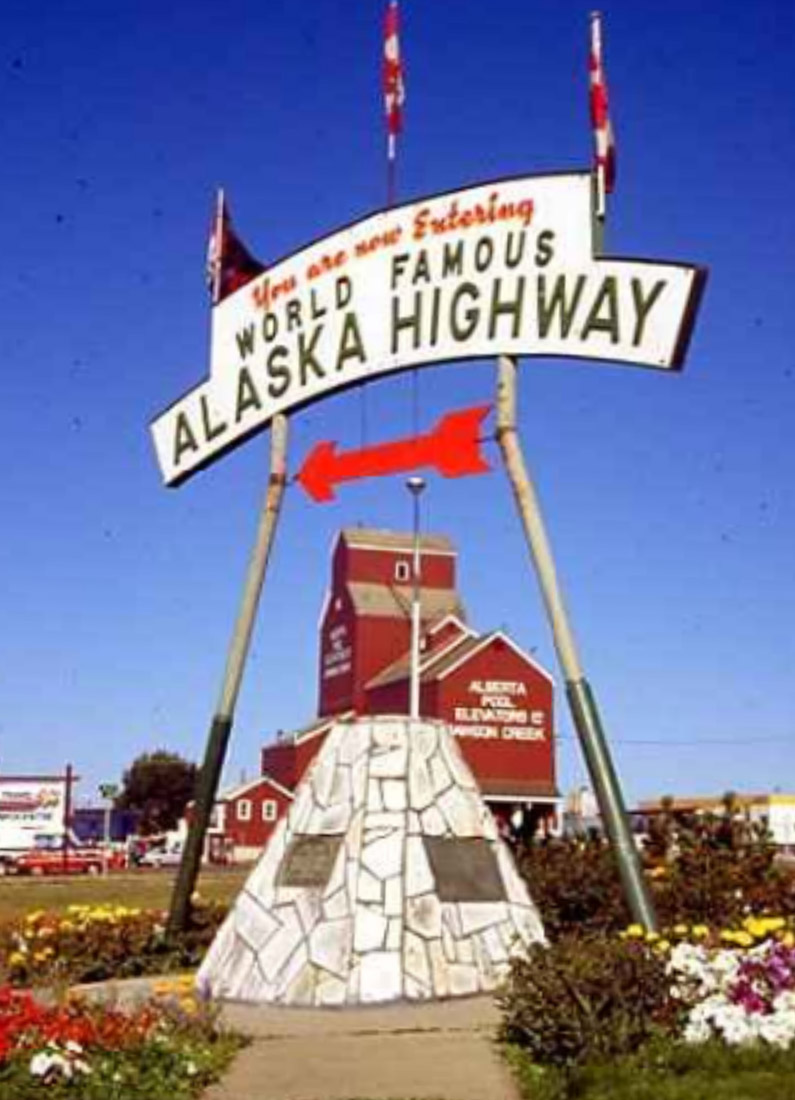
We conclude this tour of Dawson Creek at the Mile 0 Cairn that welcomes visitors to Dawson Creek and to the World Famous Alaska Highway. We hope you enjoyed the tour and learned much about this city's unique history.
If you are energized to dig deeper into Dawson Creek's story you can check out the Walter Wright Pioneer Village, located just 2.5 kilometres north on the Alaska Highway. You can see it on the left.
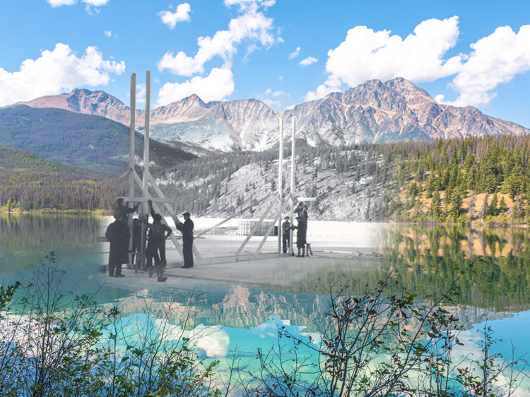
We also strongly encourage you to listen to our audio driving tour, which accompanies you on a drive through the region's attractions. It also covers the first section of the Alaska Highway as far as beautiful Kiskatinaw Provincial Park and the historic trestle bridge built there in 1942.
Endnotes
1. Peace Country
1. "The Peace River," *Tracking Change.* University of Alberta. https://trackingchange.ca/river-basins/mackenzie/peace-river/
2. The Northern Alberta Railway
1. "THE STATUTES THE UNITED KINGDOM of GREAT BRITAIN AND IRELAND, 26 & 27 VICTORIA, 1863," (London: Eyre and Spottiswoode, 1863), 358. https://www.solon.org/Constitutions/Canada/English/PreConfederation/bcbga_1863.html
3. Fertile Soils
1. A. A. Guitard, "08-003: Agriculture in the Peace – Past, Present, and Future," *South Peace Historical Society*, (1965). https://calverley.ca/article/08-003-agriculture-in-the-peace-past-present-and-future/
2. Peace River Regional District, "Regional Agricultural Plan: Background Report," (Don Cameron Associates, 2014), 8-9. https://peaceriverfarmandranchbc.com/about-the-peace-river-region/
4. The Dawson Hotel
1. Dorthea Calverley, "03-006: The Choice of Terminal for the National Alberta Railway," *South Peace Historical Archives* (1983). https://calverley.ca/article/03-006-the-choice-of-terminal-for-the-national-alberta-railway/
2. Dorthea Calverley, "03-006: The Choice of Terminal for the National Alberta Railway," *South Peace Historical Archives* (1983). https://calverley.ca/article/03-006-the-choice-of-terminal-for-the-national-alberta-railway/
5. 10th Street in the 40s
1. Harry Giles, "05-001: The Dawson Creek Story", *South Peace Historical Archives* (1959). https://calverley.ca/article/05-001-the-dawson-creek-story/
6. 1940s Street Scene Mural
1. Mike Leschart, "Inez Demuynck -- An Artist's Life," Dawson Creek Daily News, January 22, 1999. https://calverley.ca/article/bn07-08-inez-demuynck-an-artists-life/
2. "Obituary," Inez Demuynck, online.
https://www.koprivataylor.com/obituary/inez-demuynck
7. The Co-op Store
1. "The Origins of Co-ops and a Short History of Co-ops in Canada," Cooperatives First, online. https://cooperativesfirst.com/wp-content/uploads/2020/02/History-of-co-ops-1.pdf
2. "05-012: The Dawson Co-op's History," South Peace Historical Society, online.
https://calverley.ca/article/05-012-the-dawson-co-ops-history/
3. "Our History," Dawson Co-op, September 22, 2019, online. https://www.dawsonco-op.crs/sites/dawson/local/detail/our-history
4. "05-011: History of the Dawson Co-op Union", South Peace Historical Society, online.
5. "Our History," Dawson Co-op, September 22, 2019, online. https://www.dawsonco-op.crs/sites/dawson/local/detail/our-history
8. People of the Community Mural
1. News Staff, "Mural Completed and Unveiled," Peace River Block News, August 7, 2001. https://calverley.ca/article/bn07-41-mural-completed-and-unveiled/
9. Explosion Block
1. Dorthea Calverley, "05-024: The Dawson Creek Disaster: February 13, 1943", *South Peace Historical Archives*. https://calverley.ca/article/05-024-the-dawson-creek-disaster-february-13-1943/
2. "News Archives: Black History Month: The Alaska Highway", *Northwest Polytechnic*, Feb. 17, 2022.
https://www.nwpolytech.ca/news/display.html?ID=2105
11. The Americans Arrive
1. "News Archives: Black History Month: The Alaska Highway", *Northwest Polytechnic*, Feb. 17, 2022.
https://www.nwpolytech.ca/news/display.html?ID=2105
2. C.W. Gilchrist, "Alaska Highway," *The Canadian Encyclopedia*, (2013). https://www.thecanadianencyclopedia.ca/en/article/alaska-highway
3. Dorthea Calverley, "03-015: The Alaska Military Highway", *South Peace Historical Society*. https://calverley.ca/article/03-015-the-alaska-military-highway/
12. The Mile 0 Post
1. "Special Feature - The Story Behind the Dawson Creek Mile Post," South Peace Historical Society, online. https://calverley.ca/article/05-006-special-feature-the-story-behind-the-dawson-creek-milepost/
2. "About Us," The Milepost: Alaska Travel Planner, online. https://themilepost.com/about-us/
13. Lawrence Meat Market
1. Jean Lawrence and Joe Lafond, "08-064: The Meat-Packing Business in the South Peace Area," South Peace Historical Society, online. https://calverley.ca/article/08-064-the-meat-packing-business-in-the-south-peace-area/
2. Lawrence Meat, "Our History," online. https://lawrencemeat.com/about-us/our-history/
14. The Post-War Boom
1 *Dawson Creek: Heart of a Rich New Empire,* Dawson Creek Chamber of Commerce, (1957), 1.
2. "Workforce and Population," City of Dawson Creek. https://www.dawsoncreek.ca/en/business-development/workforce-and-population.aspx
3. *Dawson Creek: Heart of a Rich New Empire,* Dawson Creek Chamber of Commerce, (1957), 8.
4. *Dawson Creek: Heart of a Rich New Empire,* Dawson Creek Chamber of Commerce, (1957), 20.
15. The Hotels
1. "Windsor Hotel, Dawson Creek," *ExploreNorth*. https://www.explorenorth.com/library/roads/images-lodges/dawson_creek-windsor_hotel-19571120-%20FairbanksDaily_News-Miner.jpg
2. "The Cost of Building a Hotel in 1951," Tourism dawson Creek Blog, (Sept. 21, 2010). http://mydawsoncreek.blogspot.com/2010/09/cost-of-building-hotel-in-1951-windsor.html
16. Carlsonia Theatre
1. Dorthea Calverley, "Early Days in Dawson Creek," South Peace Historical Society, online. https://calverley.ca/article/18-104-dorthea-calverley-early-days-in-dawson-creek/
2. "British Columbia Movie Theatres: 1945-1960," Duke Filmography, online. https://dukefilmography.com/british_columbia_movie_theatres_1945_to_1953.html
17. Police & Fire Brigade
1. William Foster, "05-020: Growth of the Dawson Creek Fire Department", South Peace Historical Society. https://calverley.ca/article/05-020-growth-of-the-dawson-creek-fire-department/
19. Harper's General Store
1. "Pioneer Village Self Tour Guide," Mile 0 Park, online. https://www.mile0park.ca/pv-tour-guid
2. Dorthea Calverley, "04-023: W.O. (Wes) Harper on the Early Days in the Peace River District," South Peace Historical Society, online. https://calverley.ca/article/04-023-w-o-wes-harper-on-the-early-days-in-the-peace-river-district/
21. Places of Worship
1. "Census Profile 2021: Dawson Creek," Statistics Canada (2021). https://www12.statcan.gc.ca/census-recensement/2021/dp-pd/prof/details/page.cfm?Lang=E&SearchText=Dawson%20Creek&DGUIDlist=2021A00055955014&GENDERlist=1,2,3&STATISTIClist=1&HEADERlist=0#Note162
23. Notre Dame School
1. "10-030: Notre Dame School, Dawson Creek," South Peace Historical Society. https://calverley.ca/article/10-030-notre-dame-school-dawson-creek/
26. The Alaska Hotel
1. "Farewell to the Alaska Hotel," *Town Spirit*, Sept. 23, 2012. https://townspirit.wordpress.com/2012/09/23/farewell-to-the-alaska-hotel-2/
2. "Dawson Creek's historic Alaska Hotel destroyed by fire," *CBC News*, Sept. 15, 2012. https://www.cbc.ca/news/canada/british-columbia/dawson-creek-s-historic-alaska-hotel-destroyed-by-fire-1.1136698
27. The CIBC
1. C.F.E. Carpenter, "05-018: The Canadian Imperial Bank of Commerce in the Peace River Area," South Peace Historical Society, online.
https://calverley.ca/article/05-018-the-canadian-imperial-bank-of-commerce-in-the-peace-river-area/
2. ibid.
29. Mile 0 Hotel
1. Dorthea Calverley, "18-104: Dorthea Calverley – Early Days in Dawson Creek," South Peace Historical Society, online. https://calverley.ca/article/18-104-dorthea-calverley-early-days-in-dawson-creek
30. Tuning In to CJDC
1. Gordon Cummings, "05-017: The Birth of Radio Station CJDC," *Sout Peace Historical Society.* https://calverley.ca/article/05-017-the-birth-of-radio-station-cjdc/
31. Army Headquarters
1. Phyllis Lee Brebner, Alaska Highway: A Personal Account of the Building of the Alaska Highway, (Boston: Boston Mills Press, 1985).
32. The Local Newspaper
1. "About Us," *Dawson Creek Daily News*. https://web.archive.org/web/20120413043023/http://www.dawsoncreekdailynews.ca/section/dawsoncreek%26template%3Dabout
2. "Northeastern B.C. cities lose their last newspapers," *CBC News*, Oct. 13, 2023. https://www.cbc.ca/news/canada/british-columbia/newspapers-fort-st-john-dawson-creek-fort-nelson-1.6996249
35. Aerial Links
1. "RCAF Station Dawson Creek," *RCAF Info*. https://rcaf.info/rcaf-stations/british-columbia-rcaf-stations/rcaf-station-dawson-creek/
36. Silverado Inn
1. Dorthea Calverley, "18-104: Dorthea Calverley – Early Days in Dawson Creek,"South Peace Historical Society, online. https://calverley.ca/article/18-104-dorthea-calverley-early-days-in-dawson-creek/
2. Clarence Tibbetts, "18-092: Clarence Tibbetts – Early Days in the Peace," South Peace Historical Society, online. https://calverley.ca/article/18-092-clarence-tibbetts-early-days-in-the-peace/
37. Harnessing New Energies
1. Gerald Clare, "12-020: History of the Oil & Gas Industry in the South Peace," *South Peace Historical Society,* 2003. https://calverley.ca/article/12-020-history-of-the-oil-gas-industry-in-the-south-peace/
2. Gerald Clare, "12-020: History of the Oil & Gas Industry in the South Peace," *South Peace Historical Society,* 2003. https://calverley.ca/article/12-020-history-of-the-oil-gas-industry-in-the-south-peace/